IT’S SPRING AT SIZERGH.

P1000578 (2)

At 10 o’clock this morning I was stood in a queue waiting for my latest, I’ve lost count of how many, Covid booster. Nervous pleasantries were passed with the vaccinator nurse. I was thankfully not as old as most of the other customers. Never felt a thing. So back out into the Lidl car park on a beautiful sunny morning, no time for shopping, Soon I was home for a delayed breakfast. Despite warnings of possible side effects, take paracetamol and rest, let’s get out and enjoy the Spring weather.

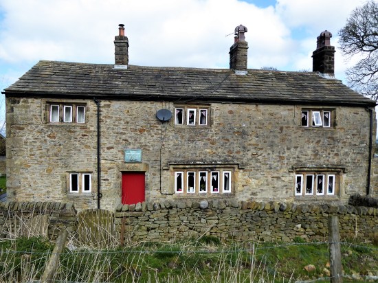
At the back of my mind was a short walk from Sizergh Castle highlighted recently by fellow blogger John Bainbridge and others. Native daffodils in the woods aroused my curiosity. Noon found me parked in the grounds of Sizergh Castle, along with many more. My NT card saved me £9 in parking fees. Not for me the delights of the garden or castle, I strode purposefully upwards. The National Trust here have been at work creating a serviceable path to  Holeslack Farm, under scaffolding but with its original orchard attached. Not many followed me. Wild garlic in profusion. 

P1000505

P1000508P1000512

P1000514

A quiet lane took me up to the church of St. John the Evangelist. Thankfully it was open, and I was able to get a good view of the stained-glass windows and the painted mural, a memorial to the lost from the WW1.  P1000524

P1000521P1000522P1000523

Outside there was a view over the Kent Estuary with Arnside Knott on one side and Whitbarrow the other. The main event however, the Lakeland Hills, was a hazy distant blur though the  plaques showed me what should be seen on a clear day. Worth returning for.P1000536 P1000531

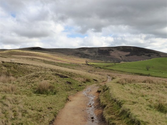
Out onto Scout Scar all was blue sky, the limestone ridge dotted with low growing trees. One can wander at will up here, but I stuck to a path along the edge of the escarpment watching the line of cliffs unfold with the Lyth Valley down below. I didn’t know the path dropping off this western side, but the map indicated a cairn. The cairn appeared and what a fine one. The track off was clear, but first I sat on the edge for a break whilst I had the views, though the far hills still hazy. I ate the last of my Xmas cake and topped up on water, a buzzard flew majestically below me. P1000537

P1000542

P1000545

P1000554

P1000550

P1000559

The way down was steep and stony through the trees. All of a sudden you are into pastures full of sheep belonging to Barrowfield  a wonderfully situated homestead. The farmer was sorting out his lambs, an age-old routine not changed for generations. P1000556

P1000577

Back into woods a narrow path threaded its way down the valley. New growth was appearing on the trees, the young beech leaves the brightest green. Continuing on a lane I bypassed Brigsteer and stayed high to the remote cottages at Well Garth. Then down through fields to Park End a picturesque C17 farm. P1000579P1000581

P1000586P1000589

P1000593

P1000594P1000596

A couple of fields, and I was into Brigsteer Woods. I just followed whichever path seemed to be in the right direction. These woods were traditionally coppiced, so light gets through to the forest floor. Everywhere were woodland flowers – primrose, cowslip, celandine, dog violet, dandelion, bluebell, wood anemone, wood sorrel, wild strawberries the list goes on. But I was too late for the native daffodils, they were well past their best. P1000604

P1000608

Native daffodils?

Out of the woods there was a short stretch through what had been an ancient deer park presumably connected with the castle estate. Back at the Castle the café was doing a roaring trade in ice creams, I was surprised by the number of children about – some must have longer holidays than others. I couldn’t resist a wander around the grounds and gardens before leaving. P1000612P1000642

P1000613P1000617P1000629P1000619P1000632P1000636P1000634

A varied area worth more exploration. I should visit Brigsteer village and maybe have a look at the bird hide on the edge of the mosses. Even a trip around the castle.

***

CaptureSizegh. (2)

CICERONE’S LANCASHIRE – A LONG DAY ON PENDLE.

P1000383

I’ve been impressed so far with the walks from Mark Sutcliffe’s Cicerone guide to Walking in Lancashire. It’s a big county covering all types of terrain from the Coast to the Pennines, and he has chosen well. I must have walked most of his routes many times in the past, but he keeps throwing up little gems of variations new to me. Today was no exception. Nobody in their right mind would climb Pendle up those steps from the overrun village of Barley, I did in October 2020  as the lockdown restrictions for Covid were being relaxed. Never seen so much congestion on the roads or hill, but I was on a mission that day to find Fox’s Well. Mark takes us the quiet but long way up from the little village of Pendleton, a hamlet (tun) close to Pendle.

Pendle Hill dominates the landscape as you drive along the busy A69 though the Ribble Valley. It was along here I came today before branching off into the peace and quiet of Pendleton. I paid my dues and parked in the village hall’s car park as suggested in the guide, Walk 34 – ‘a challenging walk‘. I have been slowly increasing the mileage that my knee injury will cope with, it is nearly a year since the cycling accident that tore the medial ligament. Time is a slow but reliable healer, today’s rough 10 miles would be a test.

The sun is out as I walk past the Swan with Two Necks, I have visions of a pint outside on the return. Pendleton is unusual in that it has a stream running down its main street making it a favourite Ribble Valley venue. The pub regularly wins awards for its beer and food. Higher up the village the Fiddle Stone, once a clapper bridge across the stream now curiously spanning a patch of grassP1000368

P1000371

P1000500

P1000501

Leaving aside thoughts of beer, I soon take a lane into fields which rise up to Wymondhouses, a Pennine farm once used as a chapel. The plaque above the door states that the first Congregational Church in north-east Lancashire was founded here in 1667, a Mr Thomas Jolly being the nonconformist preacher. P1000382 P1000389P1000393P1000392

Rougher pastures and a sunken way led me onwards higher to come out onto the road at the Nick of Pendle, a low pass through these hills between the Ribble Valley and Sabden. A popular stopping off point for motorists seeking a picnic and a view. There were quite a few cars parked up this morning, the first people I had come across.

P1000395

Back to Longridge Fell and Bowland.

P1000396

P1000399

P1000401

Sabden down in the valley.

I was quickly back to peace and quiet on an obvious bridleway heading for Churn Clough and the Deerstones.

P1000403

Bridleway with Deerstones on the horizon.

P1000407

Below is the almost circular Churn Clough Reservoir, now used for fishing. Our path crosses the clough and then climbs steeply up its right bank heading for the Deerstones marked on the OS map. It is quite a pull-up. The day has changed, the sun has disappeared, and dark clouds fill the sky. The Deerstones look menacing in this light. At the back of my mind there is something of interest in the quarried stones, but I don’t divert without good reason. (I later read of the Devil’s Footprint. This feature was natural and caused by nodules of iron rich stone eroding out the harder gritstone bedrock. The legend is that the footprint was left by the Devil as he gathered stones in his apron to hurl at a nearby church. He then clumsily dropped them at nearby Apronfull Hill. I suspect that without prior knowledge the footprint would have been difficult to find. P1000419P1000412

P1000418

The Deerstones.

The path comes out onto the open moor at a gate. Paths go in all directions. I just head north on the vaguest of paths to join the main route coming up from the Nick. Pendle is a big hill and I feel minute in this landscape, it wouldn’t take much to get lost in its vastness on these SW slopes. All is sky and skylarks. You can’t capture this with a photograph, especially now that it is so dull.

P1000428

Could be anywhere.

The path becomes more defined on the lip of the prominent Ogden Clough, a highlight of the day so far. P1000429P1000431P1000430P1000433

I have distant memories of ploughing directly up that clough in a hard winter when all other tracks were obliterated. Today the going is good and as one approaches the summit the path has been ‘flagged’ to prevent erosion. There are still very few people using this way, but I fall into conversation with Max and his dog. He is full of tales of Lakeland walking, recently having completed the 214 Wainwright’s. He admits to being a little nervous on some of the Lakeland scrambles, I encourage him to take on Sharp Edge on Blencathra and maybe even Jack’s Rake on Pavey, I am not sure if he is convinced.

P1000435

Wes, dog and flags. 

By now we have reached the summit Trig point, at 557 m,and realise the place is thronged with people from the Barley side, what a contrast to our way up. Nonetheless, it is a good viewpoint over Pendleside and a sit down for a snack, but not for long as under the cloud it is decidedly chilly. 

P1000437P1000436P1000438P1000440P1000442A new path has been fashioned from the top of the Barley steps to the trig point. I must admit it blends as well as possible into the plateau and must save a lot of erosion. There is also a new stone shelter built into the nearby wall. Once through the wall as if by magic everybody disappears, and I have the whole of Pendle Moor to myself. There is no wind today, so it is almost perfect silence apart from all those soaring skylarks.

P1000444

Empty spaces – skylark country.

Past the stone shelter and on to Scout’s Cairn, the path is very boggy all the way. The Yorkshire Peaks are a bit hazy, but I’m focused on Kemple End, Longridge Fell and Parlick, Fairsnape Fell framing Beacon Fell straight ahead. As I said photography is difficult in this light. P1000448

The moor goes on forever. But is that sunshine returning? And now for that little bit extra. After a memorial cairn I drop steeply down into the extensive Ashendean Clough, a deep incision in Pendle’s SW slopes. This could be Scotland.

P1000460

Memorial to two Clayton-le-moors Harriers members.

P1000469

Down steeply to Ashendean Clough. Can you spot the Nick on the horizon?

P1000475

The guide says to cross the stream, but that is not so easy today without getting my feet wet or even worse. A perfect little valley full of bright yellow gorse. A footbridge by a barn and I’m into rough pasture aiming for the next barn which I cannot see, but we get there in the end and come out onto the lane by Mearley Hall. That has been quite some hill day.

P1000478

P1000482P1000486

P1000489

Howcroft Barn.

P1000490

P1000497

P1000495

I arrive back in Pendleton and treat myself to that beer, sat outside in the late sunshine. Perfect. Reflecting on what has been a connoisseurs walk, mostly away from the popular Pendle routes. That has been quite some hill day.P1000502

***

CapturePendle. (2)

RAIN BEFORE SEVEN…

P1000341

                                                                      A wet Longridge Fell.

…dry by eleven.

This piece of optimism is presumably based on the weather in NW Britain, where early-morning rain could mean it has been raining all night. The front producing it may then blow through giving way to fine weather later in the day, though not necessarily by eleven. It had certainly been raining most of the night when I awoke this morning at six, and it still was at nine. A couple of coffees, a poached egg and the crossword later I wondered about getting out. I wasn’t in a rush, just going local, so let’s give it to twelve to be certain.

My previous foolproof method of forecasting the day involved looking out of my bedroom window. If I couldn’t see Longridge Fell it was raining, if I could see the fell it was going to rain. Such is life up here. But now Barratt’s have built some ghastly houses in front of me, so I can’t see the fell at all. What does that say about the weather?

Parked up at Jeffrey Hill to do my usual short round on this end of Longridge Fell. Why not incorporate a litter pick whilst I’m at it, haven’t done one for a few weeks and after Easter I expect a good collection. The clouds over Bowland still suggest rain but is that some brightness behind me coming in from the coast on the strong winds? We can but hope, and anyway I’m fully waterproofed.

P1000340

Rain in the Trough of Bowland. 

P1000337

Behind me brightening across the Fylde?

To my surprise, or should that be pleasure, there is very little litter heading up to the trig point. I suspect someone else is helping out. Apart from the phantom orange peeler all I find is the usual d** p** b**s, no surprise there. It is also no surprise to see, in the distance I’m afraid, a couple walking with their dogs off the lead. There are signs everywhere suggesting this is not a good idea due to ground nesting birds at this time of year. Tell me if I am becoming pedantic.P1000352

I splash on through the bogs, we have had a lot of rain, to the trig point, Bowland remains  gloomy. The wind is behind me but still has a cold bite to it. Families coming the other way are frozen, and the children look miserable. They have the time to thank me for my  litter efforts. Whenever I meet people whilst I’m in litter clearing mode, a conspicuous bag and a grabber, they all say they should do the same – if only 5% did that would be a success. P1000344

Approaching the edge of the woods I’m surrounded by a dozen barking dogs. All loose and followed not that closely behind by a couple of ‘professional’ dog walkers. I stand my ground, I’m getting more confident with the canine species these days – there are so many of them. Pleasantries over I suggest that on the fell the dogs should be on lead. Of course their guardians have come from a different direction and claim there were no warning notices. We walk along together, and I explain about ground nesting birds – lapwings, curlews, skylarks, grouse, plovers etc in this area. The dogs are a delight to watch as they know their way and jockey for front position. A diverse selection of breeds all getting on together. I begin to wonder that as they are staying on this side of the wall and not transgressing onto the open fell I may have been a little harsh on their human friends. Dog walking has become big business these days as people who bought dogs for companionship now need to go back to work. We part company as they go off down the forest track. Out of interest later in the day I drive round to their point of access onto the fell and there are no signs warning of ground nesting birds. Fair enough. P1000349

I’m soon back on the road and the weather, as prophesised, is improving  so I incorporate a loop around Cowling Brook Plantation. I had noticed some litter starting to appear in this woodland of late. There wasn’t much to be honest but my d** p** b**s  total now was above a dozen. I enjoy my ventures into this plantation and feel the need to preserve it. There is so much unidentified bird song in the trees today. It would be good to come here with a proper birder and learn to recognise the calls. Any offers?

The little Cowling Brook coming down from Gannow Fell is in full lively flow heading to Knowle Green where it used to power the bobbin and cotton mills. P1000355

On the short stretch up the road into the strong wind the carrier bag was getting heavier, and I was in danger of repetitive strain injury from the trigger on my grabber. P1000357

The sun was shining once back at the car and indeed we have just had an almost good red sunset. Red Sky at night  Shepherd’s delight, another ancient folk law.  A red sky sunset tells us the worst of the weather has now eased, with higher pressure and improving weather approaching from the west for the following day. Red skies appearing when dust and small particles are trapped in the atmosphere by the important  high pressure.

P1000362

What will tomorrow bring?

***

CaptureLONGRIDGE FELL (2)

CICERONE’S LANCASHIRE – ALMOST INTO YORKSHIRE.

P1000294 (2)I couldn’t resist a decent hill day as the weather remained fine. All change next week. ‘Head east old man’ was my mantra as I sped along the M65. Everyone else was going west to Blackpool or the Lakes. Boulsworth Hill my objective. So far so good, but the last chapter of Mark Sutcliffe’s Lancashire Cicerone guide would have had me parking above Wycoller. If there ever was a honeypot then Wycoller deserves that title. A secluded village of agricultural and hand loom workers in the C16th to C18th. Along came power looms in the C19th in nearby Lancashire towns and the population moved out. By 1896 the majority of people had moved away from the village, and it was virtually deserted. But a renaissance occurred in the mid C20th, the area was incorporated into a Country Park and people started moving back into the village renovating the properties. I well remember Longridge acquaintances of mine telling me of their plans for one of the houses in the 70s. I suspect you would have needed a bottomless purse to go ahead.  For more information look at Wycoller (abandonedcommunities.co.uk)

The village is a now a conservation area and is closed to outside traffic. The car park on Trawden Road is the one suggested for this walk. Today, Easter Sunday I suspect it would be probably full by the time I arrived and you have to pay. So I decided to park up in Trawden village on the line of the walk. This worked well, makes the walk more balanced and avoids backtracking at the end. I will give details at the end of the post.

Out of the car I was soon winding my way up a lane into the hills, slightly more directly than Mark’s route. Footpaths then led past isolated farms. I came across two unusual stone stiles with a circular centre and  exits into three separate fields, difficult to describe and difficult to photo, but I have never seen anything like them before. On down an ancient track into Wycoller.

P1000201

Early fields with the amorphous Boulsworth on the horizon. 

P1000202

Early crows’ nests in the bare trees. A walled enclosure like a pinfold. 

P1000211

P1000213

P1000214A good start to the day, although by now it was after noon. The expected crowds were milling around in the hamlet. Crossing and recrossing the series of bridges over the stream. For the record …P1000218P1000217P1000234

The information centre/café appeared closed, but some enterprising folk were running a mobile coffee shop, it was too early for me. This walk gives you the opportunity to explore Wycoller if you haven’t been before. I had a look around the remains of the hall and was reminded of the time when I slept in the fireplace Inglenook whilst on a two-day trip around the Pendle Way. At the time I was unaware of the phantom horse ghost story associated with the hall.  If I had known I may have slept elsewhere. P1000224P1000223

You have had enough historical homework on the area so far, and it is time to move on. There are ways either side of the stream, but the important junction is well signed leaving the Pendle Way and the Bronte Way to take a concessionary path alonside Turnhole Clough. (the Bronte connection being that Wycoller Hall may have been the inspiration for Ferndean Manor Jane Eyre’s residence with Rochester after the fire at Thornfield. The Bronte Way is a worthwhile short/long distance way)

Families were enjoying the country park with Easter picnics whilst high above the sci-fi Atom, one of Lancashire’s panopticons, looked down on us. P1000227P1000229

I don’t think I have been in Turnhole Clough before and I enjoy strolling through the trees above the lively beck. This sort of concessionary path should be more commonplace, I can think of several areas crying out for access. It just needs the local authority and landowners to come to some agreement, maybe pushed by interested rambling groups. P1000238

P1000239

P1000242

Anyhow, eventually the Clough brings me out onto open moorland. Above on the skyline is a row of rounded gritstone boulders which look interesting. I have a hill to climb today, so I’m not keen to add extra height wandering off route to them. There is a path up towards them but when I later search on the UK database there is no mention of them being climbed upon. I now regret coming so close without visiting, all I have are some telephoto pictures. What are they 10, 20 or even 30ft high, it is difficult to tell? Another day. P1000243P1000250P1000251

The book states you come out at the bailey bridge and cross it, but the concessionary path actually brings you back onto the Pennine Bridleway/Bronte Way above the bridge.  Now we head across open moorland on this ancient flagged mule track.

P1000252

Perfect wild camp site in the upper Turnhole Clough. 

P1000259

Which way? 

P1000264P1000269

Up and down until the barn where a signed path heads upwards to Boulsworth. This is a relatively new way so tends to just head upwards, none of the characteristics of worn winding historic routes. All is well until a fence is crossed and then the brutal 1000ft climb rears up steeply in front of you. I’m too old for this game but plod on at a slow pace being glad I stopped for an energising bite to eat back in the clough. Sometime later I breasted the ridge at some prominent gritstone boulders, Little Chair stones. Onwards past more boulders, The Weather Stones, I give them names in my imagination or am I hallucinating? Any suggestions?

P1000270 (2)

Start of the ascent. 

P1000275

The steepening. 

P1000282

Forever onwards to the Little Chairs. 

P1000288

P1000290

P1000291

P1000293

Up at last to the trig point at 518 m, Lad Law. There was nobody else here. Panoramic views over Lancashire and Yorkshire but now a little hazy. Am I actually in Yorkshire, well not quite but a stone’s throw away paths head deep into Bronte Country to the east. It all looks very bleak.

P1000298

Lad Law trig 518 m.

P1000302

A hazy distant Pendle over the Coldwell Reservoirs.

Turning back into Lancashire I head off downhill past the prominent Abbot Stone, too steep to contemplate bouldering.

P1000309

The Abbot.

P1000311P1000317

Boggy ground has me back on the Bridleway where after a few yards a stile takes me into fields and alongside Gilford Clough. Farther over to the right is Lumb Spout waterfall, a hidden gem. Maybe Mark missed a trick there, worth a diversion if you know where it is.

P1000320

Gilford Clough

I’m content to walk down the lane past an assortment of farmhouses, cottages, hen houses, barking dogs and allotments back into Trawden. A village where the residents run the library, pub, shop and community centre.

P1000323

Trawden FC?

P1000324

Free cooperative seeds. 

P1000327

Is they Islay? 

P1000325

Yes it is Spring but not summer.

***

My parking was on Lanehouse Lane just past the bowling green area alongside an old cotton mill where there is adequate room close to where the route enters and exits the lane. SD916380 

I was glad of this choice for it meant after a long tiring descent I was saved the climb back over to Wycoller completed  earlier. The map makes sense.

Captureoulsworth hill

A VERY GOOD FRIDAY.

P1000193I have a few ideas for some hilly walks now the weather has improved, but they would involve travelling on the busy Easter roads, so I manage to procrastinate the morning away. Let’s just stay local and have a wander up Longridge Fell checking out a few bird habitats at the same time. I’m keen to see the Great Crested Grebes performing their mating dance on the little reservoir at the top of the village. This is where I park my car. Craig Y Longridge is busy with climbers.

As I’m putting my boots on along come JD and his friend Danny. In a couple  of weeks they are off to do a pilgrimage walk through Portugal to Santiago de Compostella and are out for a brisk training walk. May I join you I ask? Yes as long as you can keep up with us. All very friendly. They set off at speed up the road, my ‘un’fitness showing. I let them do the talking whilst I try to get my breath back. Fortunately there is soon a rest break whilst they remove clothing layers, the day is hotting up along with their pace. They stuff their clothes onto rucksacks which they are carrying for training purposes.

Now into rhythm I begin to enjoy the walk as we  climb up onto Longridge Fell, my original destination. There are daffodils and primroses along the verge and bird song in the air. Young lambs play in the fields. Aren’t we lucky to have this on our doorstep?

Instead of following their intended route up the lane to the kennels I take them off on a track through the fields, past the little reservoir, on by the long abandoned quarries and just below the expensive farm conversion to meet up with the lane leading to the plantations. They claim they had never been that way before, but I doubt their memories. They stop on the ridge for a drink, I suck on an orange. Then along the balcony path above Chipping Vale to the crowded parking on Jeffrey. The first people we had met all afternoon.

We have a quick look into Cardwell Quarry where JD and I used to climb years ago as I had seen a barn owl there the other day. We see a couple of small falcons fly out – ?merlins. In the corner I spot the barn owl, get a hurried long shot (photographically I hasten to add) before it sees us and flies out – what a wonderful bird. Now I know where it roosts I creep in another day and try and get some better images. JD is surprised to see the amount of significant rock fall that has occurred over the years. Quarries are inherently unstable, one just hopes that you are not hanging on when the rock decides to part company. Anyway climbing is banned here ever since some unruly and aggressive behaviour towards the farmer from some youths partying in there. I only hope they weren’t climbers, not that it makes any difference to the ban.

It’s all downhill on the road back to Longridge past the golf course. As part of their training they feel obliged to call in for a drink. We sit on the sunny balcony enjoying a beer whilst the golfers go over their good and bad shots of the day. All very pleasant. Resisting the temptation to stay longer we are soon back into town. I had had my walk up the fell in slightly different circumstances to those envisaged and thoroughly enjoyed the banter. It has turned out a very Good Friday after all.  I’m envious of their upcoming peregrination.

A pot-pourri of images :-

P1000168

A Great Crested Grebe.  

P1000196

A busy Craig Y Longridge.

P1000190

A couple of pilgrims.

P1000191

A Million pounds. 

P1000194

A busy Jeffrey car park.  

P1000198

A distant Barn Owl. 

P1000197

A lot of recent rock fall.

***

CaptureLongridge Fell.

IF YOU GO DOWN TO THE WOODS TODAY…

P1000138

A follow-up to my post of last week on Woodland Trust sites in Fulwood.

I had to go into Preston to pick up my camera after its repairs. Wilkinson’s has served me well over the years and many cameras with personal care.. My pocket Lumix Leica had started with a fault  involving the electronic zoom – it wouldn’t. I persisted for a while using the manual setting but eventually returned it to the shop for attention under its two-year warranty. The young shop assistant tried to tell me I had damaged the zoom by dropping the camera, I explained I hadn’t. He wrote about ‘damage’ on the repair form and said he would speak to his manager – he didn’t. Subsequently, I was informed the camera’s zoom mechanism was replaced and ready for picking up at a charge of £167. I phoned to say I had disputed the cause of the failure and expected the warranty to cover the charges, the temporary assistant said he would speak to the manager – he didn’t.

I arrived in the shop clutching my warranty and asked to speak to the manager. He was very understanding and agreed that the repairers had said there was no sign of any physical damage. Of course there was no charge, I thanked him for his fairness. I will no doubt be giving this independent but expanding business, my custom in the future as opposed to the internet. Just don’t deal with the young temporary assistants.

Being keen to try it out and as I was in town I thought I would visit the two Woodland Trust woods in Fulwood omitted last week. They didn’t fit into my circular walk being more stand-alone sites. The Woodland Trust website gave me maps and access points.

ASDA WOOD.

“Public access is informal and limited. There is a stile on the southern boundary which is used irregularly as a foot access route to Asda, a network of informal unsurfaced paths run through the site for approx. 500 metres. The woodland is not thought to be well-used except perhaps by a small number of people as a shortcut to the superstore.”

The small size of this site, and the fact that it is surrounded by housing and a superstore limits its value as a wildlife habitat. Unfortunately the woodland does not l ink with any other habitats, and there is no opportunity to extend it. However, it is a mature and stable woodland which provides a refuge for urban wildlife.

Not exactly encouraging. I parked up in the far corner of the superstore car park and found the shortcut mentioned, a muddy informal track connecting to Eastway. What else did I find? Well everywhere along the border of the wood with the car park an unbelievable amount of dumped rubbish. Not just the odd drinks bottle or takeaway box, no everything but the kitchen sink. There was probably a sink in there somewhere. A lot of the mess was Asda packaging hurriedly discarded whilst on the premises, but others must park up here, well away from the public eye, and have a right clear-out. It was disgusting, and I am surprised Asda  are not sufficiently ashamed and embarrassed to do something about it.

My enthusiasm for the oaks, birch, hawthorn and sycamore dwindled – it was so messy at the edges. The woods drop away steeply and would be difficult to access even if there were paths. Best stay away, or at least just sit in the car park listening to the bird song whilst you throw away your rubbish. I notice The  Woodland Trust does’n put their usual signs up here, or more likely they have been burnt.

P1000132

P1000130P1000131P1000121P1000123

P1000122

Eastway gate into Asda Wood.

P1000128

Deeper in the wood.

CLOUGH COPSE.

A popular wood with local dog-walkers and joggers Clough Copse consists of a wide variety of tree life including oak, ash, sycamore, cherry, beech, elder, hazel and holly. Bluebells, dog’s mercury and red campion can be spotted as well.

Sounds more promising. I’ve never been into these housing estates alongside The Guild Wheel.  A maze of roads, upmarket houses and plenty of green spaces. From one of the roads where I parked I eventually found a path onto the Guild Wheel which I followed downhill towards the Old Tannery on Savick Brook. On the map I had spotted a track heading back up into Clough Copse. This well maintained way alongside a smaller brook is local authority owned. There are bridges and steps leading off into  unseen housing. The deep clough divides and there didn’t seem to be any track up the right-hand branch. The Woodland Trust announce their presence. I followed the pleasant left-hand clough and yes there were dog walkers about.

P1000133

Out of the estate to the Guild Wheel to start.

P1000136

Finding a way in off the Guild Wheel.

P1000137

P1000139P1000140P1000141P1000143

A small ‘smoke-free’ children’s’ playground appeared on the edge of the housing. I continued upwards with the stream below giving interest. Patches of Wood Anemone, Lesser Celandines and Primroses added colour. Only the Blackthorn was showing any blossom.

P1000148P1000144P1000145P1000160P1000146P1000134

All too quickly I popped out the other end onto some unknown road and was able to find my way back to the car. Really this wood is just a narrow strip  offering locals a welcome green way out of their estate. Again there was plenty of bird song, so it is providing a habitat for our wildlife.

P1000152P1000151P1000153

tempsnipASda (2)

!. ASDA WOOD.     2. CLOUGH COPSE.   Purple, route walked.

Maybe Clough Copse would be worth a revisit when the bluebells are out and the trees leafed up. But really it is only of use to the surrounding estate. Stay well away from Asda Wood.

My curiosity satisfied and the camera tested. Now after the two visits I have in my mind’s eye an idea for a pleasant walking circuit of the best of the Woodland Trust sites in Fulwood. But let’s wait until the woods are farther on after Easter.

CICERONE’S LANCASHIRE – let there be light.

P1000084The clocks have changed, but my body hasn’t caught up as yet. Today had a sparkling alpine start and promised to be the best of the week. I struggled to get up having lost an hour somewhere. But with the minimum of faffing I’m away by 10.30. It only takes me a half hour to drive out to Dunsop Bridge. I know the sun doesn’t set tonight until after 7pm, so there is no rush, that’s the way I like it.

 Walk number 12, Whin Fell and Brennand, of Mark Sutcliffe’s guide promises – Another classic hill walk  combining steep climbs, big views and pleasant riverside rambling in the secluded hills and dales at the heart of the Forest of Bowland, 

 He has covered Bowland well with ten walks on my back door. Today I parked up just off the Trough road as recommended. Soon I was following a permissive path alongside Langden Brook. Oyster Catchers seem to have taken over many of our rivers but in the background I could plainly hear Lapwings and Curlews. This is open fell country,but since 1960 their numbers have dropped by 85%.P1000019P1000020

P1000023

Crossing Langden Brook.

Back on the road I pass the farmstead of Sykes.

P1000025The lime kiln gives a clue as to the bedrock hereabouts, but I shall soon be high in gritstone country.P1000026

The Trough of Bowland road snakes ever so slowly up the valley. I branch off right and have my own hill to climb.

P1000038
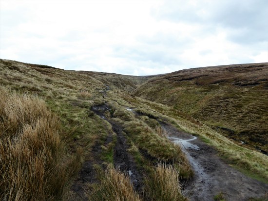
The track soon peters out, and I’m left on boggy pathless territory forever upwards. This is designated as a bridleway, and I remember coming this way on a mountain bike 35 years ago with my son. No chance now. This area is isolated from the usual Bowland haunts, and I’m surprised to meet three walkers descending the pass. A friendly trio and we exchange banter. They have driven up from Manchester,  preferring this area to the crowded Peak District. They soon become a dot on this vast landscape as they descend towards the Trough Road and I struggle upwards. Across the way Totridge Fell keeps its head above most of the fells around here.

P1000039 (2)

P1000050

P1000063

The last time I was up here I continued to the top of Whin Fell with views to Morecambe Bay and beyond. This certainly feels like the centre of Bowland. Today I was conserving my energy to complete a rugged 7-mile circuit. and I soon reached the boggy col. Way down in the valley was Brennand Farm – the promised land. All I had to do was traverse Ouster Rake. It wasn’t as bad as I remember it. Over the years a groove has been eroded into the hillside making it feel far less exposed. But come a harsh winter and this becomes an icy trap where there have been several accidents. I still don’t believe I have cycled this route. I find a flat rock and eat my sandwich gazing down into the Brennand Valley, I must follow it higher into the hills one day, I don’t think I have ever been to the evocatively named Whitendale Hanging Stones.

P1000059

P1000078

P1000077

P1000069Looking back I was surprised to see how steep and craggy are the northern slopes of Whin Fell. At Brennand Farm (notice how it complements Sykes Farm passed earlier) all is pleasant with newborn lambs in the fields, no Spring walk is complete without some lamb photos. On down the Brennand Valley and then strangely back upwards to join Whitendale.P1000087

P1000092

P1000097

P1000101

P1000104

Looking back up the Brennand Valley.

From the water catchment works under Middle Knoll the River Dunsop gathers pace down the valley. All very familiar to me. I, too, gather pace alongside it on the good tarmacked water board road. I stop to try, unsuccessfully, to capture a photo of the Dippers merrily skimming down the river.  Sometimes Kingfishers flash up this section . There has been a lot of tree felling along here in the last few years. I’m soon onto those boggy fields I traversed last week to get me back onto the Trough road below Mellor Knoll and Totridge, and my car. There is plenty of light left for further exploration. Don’t get your Middle Knoll get confused with the Mellor Knoll.

P1000106

Joining Whitendale.


P1000108

Middle Knoll overlooking the Dunsop Valley.

P1000109

P1000113

Across the fields with Mellor Knoll and Totridge ever present.

CaptureWhin Fell

Post script. You will recall my horror the other day at the erosion being caused in the beech woods on the lower slopes of Totridge Fell above the Inch Perfect Trail Bikes outfit. Well let’s take the bull by the horns and drive up to their headquarters. It’s a long lane up to ‘New Hay Barn’ as it was. Now the centre for trail bike riding with accolades from Lancashire Tourism. I must admit they have developed a professional trail biking heaven. Lots of  manufactured technical obstacles in the lower fields for the enthusiastic biker.  I enter the impressive shop full of no doubt expensive bikes and kit, electric ones being top of the range. Videos are playing of the destruction they are doing to the hillsides. All very Formula One. 

P1000117P1000119P1000116

Simon the manager is on the defensive as I casually say I had been on the public bridleway on his land last week and was distressed  to see the erosion and damage being perpetrated in the beech woods above. He asserts that all has been verified planning wise, though I doubt the fine details. He seems to imagine, erroneously, that the bikes don’t go as high as the woods. His main grouse is dog walkers at loose amongst his trail bikes, albeit on a public bridleway. Being in a mellow mood I forget to ask him who actually owns the land (is it Duchy Land?) and does he have marshals out on trial days to warn the public  of the surrounding danger. We part with him saying he will have to have a trip up into the woods where I am showing concern. He has not seen the last of me. This is an Area of Outstanding Natural Beauty after all. Or is it?

Calm down. As I leave ahead of me is one of my favourite Bowland venues, Kitcham Hill Woods on Birkett Fell. All peace and quiet, long may it remain so, but I do wonder who will be looking after our countryside in the future.

P1000118 (2)


CICERONE’S LANCASHIRE – Whitewell, Mellor Knoll and the Hodder.

DSC00293 (1)

Haredon rook connects with Langden Brook which connects with the Hodder just after the River Dunsop, itself formed from the Brennand and Whitendale  waters, has joined in. In this part of Bowland there is a lot of water flowing off the hills down the Hodder towards the Ribble. So much water that I couldn’t safely cross the stepping stones at Whitewell this morning. Walk number 14 of Mark Sutcliffe’s Cicerone Lancashire. 

DSC00448 (1)DSC00445

The day promised the best weather of the week – sunny,mild and dry. And it was. I adjusted and parked up at Burholme Bridge a little farther up the Hodder.

The climb up the quiet road was a good warm-up before taking the footpath through the field.  It felt good to see Lapwings flying around and a couple of Curlews in the distance. I was in limestone country and all around were little outcrops and caves, I have explored some of these in the past so was content to walk by. The lane leads into the hills and a far off farm under Totridge Fell, but the bridleway goes off right into the woods. At one time there were numerous hen houses scattered about, true free-range poultry, but today there only seemed to be one shed left standing. 

DSC00300

Unnamed limestone caves.


DSC00307

The ‘last’ Whitmore hen house.

The path through these woods, Lower Fence, has always been boggy but since recent felling matters have improved somewhat. As height is gained views open up into the heart of Bowland above Dunsop. Leaving the firs a contrasting beech wood is entered. I have always enjoyed this high woodland stretch – beautiful beech trees with Totridge Fell towering above and views down through the trees to the twisting Hodder where I had parked. The farm below has hosted off-road motorbike trailing for some time, but it was confined to the lower fields and contrived obstacles. Inch Perfect Trials. There is now evidence that they are riding higher up into these ancient woods causing erosion and damage to the tree roots. Their promotional video illustrates this clearly. No doubt the land belongs to the organisation but, call me a spoil sport,  I don’t feel this is appropriate in the wild surroundings. Worryingly they seem to have received several Lancashire tourism awards. We don’t need that sort of tourism. Let’s not forget we are in the Forest of Bowland, a recognised Area of Outstanding Natural Beauty. I certainly would not like to walk this Public Bridleway when they are out to play. Who should I complain to? The King, if this is Duchy land? Now I’m home and writing this I am even more incensed – they are going to destroy that beautiful beech wood.

DSC00316

How it should remain.


DSC00313

Encroaching trails.


DSC00319

The Hodder Valley below.


DSC00322

What it is becoming.


DSC00323

Erosion…


DSC00321

…erosion


DSC00325 (1)

Destruction.

Maybe my mind was distracted, but I went astray at the col between Totridge and Mellor Knoll. It is easy to do so on the featureless ground. But basically all routes lead down to Hareden in the end. Incidentally if you are up here it is easy to gain the 344 m summit of Mellor Knoll, although there are no rights of way. Why wasn’t it included in the CRoW act’s open access land?

DSC00334 (1)

Mellor Knoll.


DSC00338 (1)

Off track.


DSC00344 (2)

Haredon, can you spot the car on the trough road?

At the farm a trailer was full of sheep presumably off to market. When I asked the little girl with her mother if they were her sheep she proudly said yes. the mother quickly intervened to say that they were going on holiday. Very diplomatic. 

DSC00349

Going on holiday!


DSC00352

Haredon Farm. 1690.


DSC00350

Always a warm welcome.

it was flat walking down the valley into Dunsop Bridge, but the weather had clouded over and become much colder, don’t we have a mixed climate. Mark’s route fortunately brings you past Puddleducks café, still functioning as an outside venue, I enjoyed a coffee. 

DSC00354

Hareden Brook, haunt of Dippers.

DSC00355

Langden Brook.

DSC00401

Puddleducks in the old post office.

DSC00405

On past that 100.000th BT phone box often considered the centre of Great Britain. Down the avenue of tall Redwoods to Thorneyholme Hall, once owned by the Townley family of Burnley, known for breeding race horses. Their land agent Richard Eastwood had success in the 1861 Derby with Kettledrum. It is believed that St. Hubert’s Church in the village was partly financed though the horse’s winnings. More of that later.DSC00408DSC00411 (1)

The path down the valley alongside the Hodder, now joined by the Dunsop and Langden Rivers, is always a joy surrounded by all those familiar hills. This is a good place to watch Sand Martins but of course they haven’t returned yet. The river bank in parts is being eroded, and the path has been changed with the introduction of those modern metal kissing gates which I don’t feel are very sympathetic with our countryside. That is the last of my gripes.   

DSC00415

Langden Brook joining the Hodder under the watchful eye of Mellor Knoll.

DSC00417

What’s wrong with the old one?

Since I was last along here the farm at  Burholme has had its rendering removed exposing lovely warm sandstone. The farmer busy with his lambs tells me it has C14 origins. Their Lonks are not to be messed with.DSC00423

DSC00419

By the time I was back at the graceful Burholme Bridge the sun was shining again.

DSC00436

I then drove back along to Dunsop Bridge to have a look at St. Hubert’s which I had become more aware of through  this blog.  All the history is there to read and I won’t repeat it. See also its listed building entry. The church sits squatly by the road leading to the Trough of Bowland.  The striking feature externally is the large white marble angel guarding the Towneley family vault. Inside I found very little lighting to fully appreciate the fittings. The exquisite stained-glass windows however showed up really well. Their leaflet describes a painting of Kettledrum, but I was unable to locate it. Mary Towneley  of more recent equestrian fame is also buried here. 

DSC00388

DSC00391 (1)

A good walk in the best Bowland scenery, which in truth I have done many times before at all times of the year, but never get tired of. (I did exactly the same walk on May 1st 2019.)  If you are intending to follow the Cicerone route in full come when the river is down so the stepping stones can be traversed and maybe a pint taken in the Inn at Whitewell.  There is a concessionary path off the road from near Burholme Bridge directly back to the Inn at Whitewell which would save some of the repetition of his route. 

DSC00451 (1)DSC00458                

CaptureHaredon

DSC00448 (1)

SOME FULWOOD WOODS.


DSC00440

David Attenborough has just told me and the rest of you on his latest TV documentary that the UK has the worst woodland density of any European country. That does not surprise me given our government’s rough shod treatment of our environment. They don’t even approve of Attenborough’s climate predictions. Who would you trust our natural treasures to – David  or Sunak, Hunt, Coffey et al.  We are woefully short of natural diversity and though it is small scale  The Woodland Trust charity have something to offer on a local level and potentially a wider scale the more people know of them and their work. But how much more we need to do to re-establish our natural woodlands after years of local destruction for housing, transport, agriculture and sterile forestry plantations.

This was to be an afternoon of exploration which will be of little interest to most of you. Fulwood lies to the north of Preston hard by the M6. A land of suburbia, upmarket houses and expensive cars. And it is spreading fast to link up with Broughton and Cottam. New estates appear by the month and roads struggle to cope with the traffic. Alongside the motorway industrial units and office blocks use up most of the remaining land. So what is a ‘mountain man’ like me doing here? Well for a start mountains are off the agenda until hopefully the knee has improved. Secondly I noticed on a walk on the Preston Guild Wheel last week lots of tempting linear woodland walks. Most of them signed and presumably maintained by The Woodland Trust charity. A fellow blogger Clare highlighted some woods in the area a year ago, and I have to thank her for that. It lit a spark in me, and I am off to discover what has been hidden under my feet or wheels all those years. 

A bit of research on The Woodlands Trust website  showed an interactive map of all their woodlands. I focused in on the Fulwood ones.

Capturewoodland Trust

Armed with a sketch map I left Fulwood Row onto the Guild Wheel through Hindley Hill Woods. ( Fernyhalgh Woods  according to the Woodland Trust Map, but let’s not quibble. On the east side of the Motorway alonside Savick Brook they are named Squire Anderton’s Woods. I traversed these on my Haighton walk last week) This is all familiar territory but once I crossed Longsands Lane I diverged from the GW north into Midgery Woods, crossing Savick Brook, and going uphill towards the constant drum of the motorway. The path goes alongside the motorway for 300 metres with expensive looking houses to its other side, they must be glad of the belt of trees to give them some insulation from the noise. One could carry on along here all the way to Moss Leach Woods, but I’d had enough of the noise so took a pleasanter path through trees over the roundabout and re-emerged back onto the GW at Midgery Lane. I followed the Wheel northwards until I came to the entrance to Moss Leach Woods on the right. I had a quick foray in the woods towards the motorway out of interest before continuing.


The Guild Wheel.


Savick Brook.

Heading to the Motorway.

On the map is marked Cromwell’s Mound in a field just off the Guild Wheel – I had never noticed it before. A public footpath crosses the field here just south of the mound which to my surprise was clearly visible, although I need a better photo. ‘Cromwell’s Mound  fieldwork remains in good condition and is a rare example of a monument associated with the Second Civil War of 1648.’  For the full history behind this mound have a read here.  The developers have encroached upon this historic site with the planning departments colluding.

A fuzzy Cromwell’s Mound.

I should have just carried on across the field but instead retraced my steps and followed a narrower path continuing in the Moss Leach woods by the stream. This was very muddy and came out at the same place as the Public Footpath – lesson learnt. I was now on the busy Eastway, again I could have gone straight across, but I wanted to look at the strip of woods heading south from the road just past the roundabout. Walking alongside this road is not pleasant. Thankfully the strip of woodland was signed, and I enjoyed a good stretch.  I probably passed over the moat of the demolished Broughton Tower along there somewhere, another one to come back to. The path narrowed alongside houses, and then the way continued onto Tower Lane, showing cobbles in places near Tower Farm. This made up lane. now between upmarket properties, came to a T-junction. With the lack of knowledge of any other ways I turned left and soon reached Eastway again.  I walked down the grass verge, there being no footway, until I reached the entrance to Mason’s Wood. Looking at the map I could have reached this point  more easily from the Guild Wheel, cutting out the loop to Cromwell’s Mound. but that wasn’t the point today.   

North end of what had been Tower Lane.

Tower Farm.


How much?


Eastway – best avoided.

Mason’s Wood was a gem. a deep wooded valley with the path winding along it. Little bridges lead to paths rising to the housing on the west bank, whilst hidden on the left was Preston Golf Club. This could become a favourite of mine. The wild garlic was just leafing up. 

Entrance to Mason’s Wood.

DSC00388 (1)DSC00389 (1)

At the end a footbridge took me across Savick Brook and onto the edge of the smart looking golf course, complete with its usual warnings and arrows. But all went well until a muddy exit back onto Eastway which I then followed until Fulwood Hall Lane on the right. To escape from the busy road I ducked down here and found a path following Savick Brook upstream. I still had to cross and recross the busy roads again at the roundabout to continue upstream. That bit needs sorting out.

Savick Brook again.


Preston Golf course.

DSC00418


The light was fading, I hadn’t set off until 3pm due to faffing, so I increased my pace along the good path. This linear wood is called Sandybrook, another Woodland Trust site, and is three quarters of a mile long. (Header Photo of Sandybrook) All these hidden woods. It was only in this section, bordering onto the Brookfield estate that I encountered any serious litter. Most of the woods had been clear of rubbish and thankfully poo bags.

Entrance to Sandybrook.

At the end I emerged back onto Fulwood Row, the end of my walk, just as the rain started. Here were present day reminders of the natural habitats we must have lost whilst this area was being and still is being developed, but credit to The Woodland Trust for preserving some of these linear wild life spaces.

Extending Fulwood Row!


This is a fairly mundane write-up, out of necessity, to find, explore and possibly link up the various woods. There is so much green space hiding away from the busy roads in the area, Strangely I feel I have had a good ‘country’ walk today. What must it be like when the bluebells are out and the trees showing much more greenery? Already I can see how to tweak the route to avoid the dreaded Eastway, yet still experiencing the best bits. Today I  walked about six miles, but I think an excellent route of about four miles avoiding roads would be possible. The green lungs of Fulwood. My convoluted route is shown on the map below, but I’m sure there will be more to come of these woodland walks in the heart of the city. (Is Fulwood in the city?)

The Woodland Trust site shows two more woods I didn’t or couldn’t incorporate into today’s walk. Asda Wood and Clough Copse. I will make a separate trip to these, and maybe incorporate a bit of shopping at Asda at the same time. Additionally, their website has some very good information on tree identification and other matters natural. Worth a visit and a donation at https://www.woodlandtrust.org.uk/

***

CaptureFULWOOD

CANAL AND COASTAL CALM, UNTIL…

DSC00392

What a relief to find Sir Hugh at home, I needed a cup of tea and a sit down. I had just struggled to finish a 25mile bike ride. As I left Morecambe along the old railway line I seemed to be tiring fast despite having eaten well. Cyclists seemed to flash past me, I made the excuse they must have electric assistance. I had just travelled through what I consider a dodgy section of the cycleway. A haunt of drug addicts and other undesirables. One had just tried to punch me as I passed, try ducking and slipping on a bike. He just missed, probably because he was drunk.

After a few more hundred yards I was coming to a standstill. Only then did I look at my back wheel – the tyre appeared awfully flat. I suspect I had ridden over some glass in that dodgy area. Five miles back to my car at Halton, should I just battle on. I did have a spare inner tube on me, but it would take quite a while to fix in these cold conditions, so I peddled on becoming slower and slower. At a bench entering the city I stopped –  A. for a rest and B. to try and pump up the tyre. The former helped, but the latter lasted about 50 yards before I was reduced to a crawl again. Only three miles to go, so I got off and walked for long stretches The afternoon’s rain was coming in fast, so I remounted and pedalled as best I could to reach the car just as the down pour started. I was knackered and hence the need for a visit to Sir Hugh. I can sort out the puncture tomorrow at my leisure, why is it always the back wheel with all its complicated derailleur gears?

The day had started far more optimistically, cold but dry as I pedalled up onto the Lancaster Canal Aqueduct over the Lune. We have had some topsy-turvy weather this week. But now all was peace and quiet, even the dog walkers stopped and held their precious pouches until I had passed. Good progress was made along the towpath, here in reasonable repair – in contrast to that leaving Lancaster to the south, which can be a nightmare on a bike. My plan was to extend my usual route by cycling onwards to Carnforth. I love this elevated stretch above Hest Bank and Bolton-le-Sands with views down to the coast. Carnforth was busy with a market in progress. My route took me past the infamous station, the last time I visited it for a ‘brief encounter’ in June ’22 I ended up with Covid. I hesitated before repeating the process but the thought of coffee and cake was too much. I had awoken this morning to find I had no bread or little else to concoct a sandwich. All was cheery and friendly in the 1940s café –  a good latte with  a slice of iced flapjack did the trick.

DSC00363

Lancaster Canal Aqueduct over the Lune.


DSC00366

Sailing high above Hest Bank.


DSC00369

Woodland approaching Carnforth.


DSC00373

Brief Encounter.

Refreshed I continued alongside the River Keer, under the threatening Main Quarry on Warton Fell. Deceptive bends and plastic icebergs re-emerge into my conscience, it was always a frightening place to climb. Onwards without destroying the peace.

DSC00383

Warton Crag and quarry across the marshes

Soon I was back on the canal, reversing my morning’s route. If only I had just ridden back along it to Lancaster.  Bur no, I could not resist turning off at Hest Bank to cruise down to the promenade and follow the Bay into Morecambe. It’s becoming a habit. The tide was out and one could hardly make out the sea.  It’s different every time I come along here, that’s the charm of Morecambe’s seafront.  I sat on a bench looking out across the bay.

DSC00395

Bench on the bay.


DSC00299

Morecambe’s cormorants.


DSC00399

Low tide walk about.

Then all my troubles started.

***

CaptureCarnforth.

***

As a footnote I have to thank Sir Hugh for his hospitality at short notice. A few of you I know follow his blog and will be aware of is modelling skills. Well here is the professor in his modelling den.

DSC00402

HAIGHTON VARIATIONS IN TURN.

DSC00350

***

An urban rural walk.

Call me a wimp or whatever, but I’m keeping my walks to lowland lanes at the moment. Good surfaces and a modest distance. I’m rather pleased I didn’t cycle today as to start there was a fresh wind which seemed much stronger than the forecast suggested.

Haighton is a scattered farming community to the east of the M6 between Fulwood,Preston and Grimsargh. Possibly best known for the C17 Haighton Manor, a well respected and longstanding dining establishment.  I have included walks through Haighton in the past  here and here and briefly here.

Coincidentally these other variations were all walked in the early quiet Spring months, as of now.  “For everything there is a season” Ecclesiastes 3:1-8.  A time, add another turn for Haighton. Also, time for a tune, a bit of optimism doesn’t go amiss at present. I remember hearing many other artists covering this song during  the 60s live folk scene in London.

A good reason to repeat parts of those walks today is that Haighton Green Lane was closed to through traffic due to new gas mains being installed. It is normally a busy rat run route in and out of north Preston with speeding motorists, not the safest of pedestrian routes.

I find a small parking space at the bottom end of Cow Hill and stroll down the hill to cross Londonderry Bridge over Savick Brook which winds its way down from Longridge. Ahead are the gates and security cameras of Haighton House, once  the residence of David Moyes when he managed Preston and then Everton. I slip up a narrow bridleway alongside the noisy kennels and climb into the woods. DSC00319

At the top was always a gate securely guarded by a fierce mastiff. The PROW went through the farmyard, but he ensured that one followed the ‘illegal’ diversion around buildings. But today the gate is open with no sign, hopefully, of the dog, but I still take the long route just to be sure. The amount of accumulated waste building materials dumped alongside the rural lane farther on has grown since I was last along.  DSC00321DSC00323

I come out onto Haighton Green Lane at the top. It is indeed closed to traffic but being a Sunday no work is taking place, (no wonder road schemes go on for months – one would think that if a closure was in place the contractors should work at full pace) Despite the narrow route some drivers try to squeeze through only to back up when they meet another vehicle. On the whole though the lane is peace and quiet.

DSC00326 I’m tempted to go off down Fernyhalgh Lane past the old school (where my children started) the church and Ladywell Shrine, a shortcut back to Savick Brook. But no, I need the mileage and the day is fine, so I continue on the road whilst it is virtually traffic free. There are some fine houses along here as well as the original farms. DSC00328

DSC00327Crossing the M6 motorway I stop to watch the southbound lanes coming to a standstill., a well-known black spot. Preston Bypass, as it was known then in 1958, was the first motorway to open in the UK.  Since those days it has been incorporated into the M6 with new junctions and carriageways. I try to avoid driving on busy motorways with their frequent hold-ups and after my frightening experience of breaking down last year on a ‘smart’ section of motorway that has been reinforced.

DSC00332

By now we are now on the edge of the countryside. Housing developments are met, creeping out of Preston along the once country road on both sides. I am no stranger to these as they are also engulfing the Preston Guild Wheel cycle route which I now turn onto. I slip past industrial units, smart new office blocks and the back of an Asda superstore. But it is traffic free and not so bad. Lots of people use these stretches for recreation, strolling, dog walking and cycling. Walking today instead of my usual cycling I notice more connecting footpaths going off in all directions and stretches of linear woodlands inviting investigation, many signed by that admirable charity The Woodland Trust. That gives me an idea for a time researching them and a day of exploration and maybe linking them together. When I think back I seem to member Clare of  Dreams and Adventures at Cosy Cottage  writing about them during lockdown.

DSC00336

DSC00334

DSC00340

The section of the Guild Wheel through Hindley Hill Woods above Savick Brook is always a delight and I turn off onto Fernyhalgh Lane, though I notice more woodland paths on the north side of the Brook I could have used. DSC00342DSC00344

Now back under the motorway, at the bridge I don’t climb to Ladywell  shrine but take the road into the grounds of Haighton House. A lovely stretch through the well-kept estate alongside the river. Then a more wild stretch above the convoluted water, an Ox-Bow Lake is obvious and soon there will be more, even the path has been washed away here. DSC00348

DSC00349

DSC00356

I’m soon back at Cow Hill and a climb up the lane to my car. DSC00358

The temperature had by now slowly nudged into double figures and I felt decidedly overdressed, but I’m not going to complain.  It was still only noon when I arrived back home, so I had time for a short bouldering session up at Craig y.   I was the only one there, I wonder why, after the crowds last Sunday. Compare and contrast,as my art teacher used to say.

DSC00360

This Sunday.

DSC00277

Last Sunday.

Variety is the spice of life.

***

tempsniphaighton

IN LIKE A LION…

DSC00304This week I have been alternating short walks and flat cycle rides with nothing of note to report. Everything came to a standstill yesterday with the collision of cold winds from the north with a front from the south. Amber warning. My son cancelled a lunchtime visit from Manchester and I watched the snowflakes falling in the afternoon. During the night things must have turned nasty as today I woke to a couple of inches of snow. (The radio told of far worse conditions in the Pennines) It was interesting to try and identify the  tracks across my back garden, one doesn’t know what transpires in the night. Something I should resolve either with sitting up into the wee hours or more likely installing a motion detecting camera.

By mid-morning the sun had appeared and traffic started using my road. Time to get out and about. The tossed coin said walk. So I did. A brand-new pair of lightweight boots had arrived in the post. Helly Hansen and looking perfect for summer walking – right let’s try them out in some snow. Living in Longridge I am lucky to be able to walk from my doorstep into the open countryside or as I did today up onto the fell. The route on roads was one of my regular runs way back then. I knew it would give me good Bowland views with the minimum of hassle.

Once out of the village ‘Forty Acre Lane’ gave me those promised views. I’m not sure which side the ‘forty acres’ are on but never mind the vista across Chipping Vale to the hills is uplifting. The snow on the south slopes was visibly melting as I walked but showed up the features of the Parlick, Fairsnape and Totridge Fells in great detail. Virtually no cars passed me, the road was just thawing enough for them. There were still drifts in the gateways. The golf course was closed, perhaps prematurely as the afternoon was perfect.

DSC00306 DSC00305

DSC00303

The usual crowd of cars was parked up at Jeffrey Hill. From up here the northern slopes of Pendle Hill were plastered with snow – they usually have it worse in East Lancashire. I was in two minds to take to the fells with the rest of them and visit Spire Hill, instead keeping to the road but no sooner had I decided this I was tempted off into Cowley Brook Plantation. My favourite getaway place. It was a joy to tread virgin snow through the trees. Silence was everywhere except for those little birds singing unseen. DSC00310

Back out on the lower road I trudged back along the switchbacks to Longridge as the temperature started to fall again. The roadside gorse was a brilliant yellow.DSC00302

How good that sunshine must have done for my endomorphins.

***

CaptureLongifdge fell

A NEW SEASON?

DSC00275 (2)

Trying to spread my diminishing physical  ‘talents’ around – walking, cycling and climbing. today after a miserable week of wheeziness and coughing I made the effort to drive up to Craig Y Longridge not that it is very far. Would it be a step too far? Possibly.

I’ve been coming here for years, far too many. I’m probably four times the age of the young dudes who come from afar to test their strength and skills on one of England’s premier bouldering venues.  This strenuous training crag (more correctly a quarry) is fortunately on my doorstep. Every spring I am determined to get strong again.

I’m surprised by the number of people here today, but it is dry with a glimpse of the sun and temperatures nudging above 6 degrees. We all climb in hope. The colourful crowd is mainly one group from Lancaster. All a friendly lot. Whilst they hurl themselves at desperate overhanging problems I slouch off to the easier far end where I can play around on some familiar traverses. I’m only feeling my way back to fitness but as I climb that old buzz kicks in, and I start to enjoy myself and pull off some  smart moves. But not for long – the strength soon runs out. Still, there is time to chat with the others, passing the time of day and reflecting on past days and crags. They tolerate my reminisces, I only hope time will be memorable for them too.

Well satisfied. I can but try.

DSC00277

New school bouldering.

MORE MORECAMBE.

DSC00181

You may wonder why I keep coming back to the Bay. My cycling is for leisure and pleasure these days, and there is no pleasure on the busy roads around Longridge. The old railways, cycleways and canal up here are ideal and one has the added benefit of the ocean breeze and those views across the bay. Oh, and it’s all relatively flat.

I suspect that sometimes I am bewitched by that view and neglect little details on the promenade. Well today I paid more attention to what was under my feet, I mean wheels, and I ended up walking stretches of the front so as not to miss things.  I had arrived onto the front near Heysham via a new route, for me, which diverged off the old railway/cycleway and wound its way through the White Lund Industrial Estate, lovely.

From the start at Sandylands I notice several, about three dozen, round interpretative discs set into the promenade telling the story of Heysham, Morecambe and the Bay. A quirky addition to the front. For a more detailed history and lots of old photographs and archive material it is worth visiting the Maritime Museum on the quayside in Lancaster. Morecambe has certainly had a chequered history – but the future with The Eden Project hopefully under way should be more positive. It is frightening to realise that I am part of that recent history, bringing my family up to the amusement parks and aquarium still in existence 50 years ago and now no longer. I try to remember if the central pier, mentioned more than once in the discs, was still standing on our visits. It is suspicious that there were so many fires on the derelict piers. DSC00195

DSC00182

DSC00189

DSC00190

DSC00193

DSC00203

DSC00208

DSC00210

DSC00211

DSC00209

DSC00217

DSC00226

DSC00229

DSC00230

DSC00232

DSC00192

Capturepier

Morecambe in the 1940s. The two piers highlighted.

So there you have it. On the way I passed this house painting, an old pier/breaker, a couple of turrets and these elegant Edwardian terraces. Fading glories.

DSC00228

DSC00218

DSC00248DSC00221As I approached the west end of Morecambe I was intrigued by a large building set back from the front. The building now known as The Battery once marked the boundary between Morecambe and Heysham. (in 1928 the two districts merged). In the nineteenth century the site was occupied by an old mill and the area was later used as a firing range, with an artillery battery stationed there because of fear of an invasion by the French. The mill, then known as The Roundhouse, was used for storing ammunition. The Battery Inn was built in 1863 and in 1900 it expanded to become The Battery Hotel, later acquired by Thwaites Brewery and functioned into the 1980s. It has recently been bought by a property developer for conversion into luxury flats. I’m not sure whether much progress has been made.

DSC00237

I don’t think the adjacent Beach Cafe is the best of architectural designs.

DSC00243

My informative circles had finished, but something on the road caught my eye –  half a car to cut your motoring costs, an effective advertising gimmick.

DSC00252And what’s more on the other side of the road a series of artistic panels brightening up an otherwise drab development hoarding at the former Frontier Land. I now remember Eunice from the Mouse House mentioning them here and here in far more detail than my pictures below. Local artists are highlighted. Several showing Eric the town’s celebrated son.


DSC00254

DSC00261

DSC00256

DSC00258

DSC00264DSC00263DSC00266DSC00260DSC00268

I hope the Midland Hotel is given anew coat of paint before Eden arrives.

DSC00240

By now my hands were frozen in the cold northerly wind whipping down the promenade. Time to get cycling again. On past the Midland, Happy Mount Park, Hest Bank and onto the Lancaster Canal back to Lancaster. I had just about warmed through by the time I reached my car at Halton. It’s only half an hour back down the motorway, but I have a sense of lingering guilt that I shouldn’t be driving farther than I’m cycling.

***

CaptureMorecambe

DISAPPOINTMENT.

DSC00167

I was actually in Cowley Brook woodland that is on the fell road below Geoffrey Hill. As I entered through the small pedestrian gate I could hear and then see a small flock of common crossbills high up the Scots pine”   Grimsargh Wildlife Forum. 21 February at 15.22.

Having read that this morning and not having seen a Crosshill for years I was parked up by the plantation after lunch. I entered through the same small gate and wandered into the pines. I could hear what I thought were Crossbills somewhere in the depths…

♫ Red Crossbill – song / call / voice / sound. (british-birdsongs.uk)

…but I could not see them. I wandered up and down the plantation just above the brook, stopped and listened, scanned with my binoculars – but not a sighting. I completed a loop around the plantation, still hearing them in places, I concluded that I’m not very good at bird spotting, swallowed my pride and disappointedly headed back.

DSC00161

As I was walking around I was disappointed to see that it has been necessary for United Utilities to display on several trees notices reminding dog owners to remove their dog’s mess. That is despite large notices at the entrance gate advising on sensible conduct. It struck me that if they, the dog owners, don’t heed this then the additional signs will have little effect. What a shame that this little wild life area is suffering from urban park mentality and that the ‘wildness’ is being polluted, in my opinion, by additional signage.DSC00164

Back at the gate I had my third disappointment- a great pile of rubbish, overwhelmingly dog poo bags. Perhaps these had been collected by someone, but why not bag them and remove them from the site. On the gate are some bin liners for people to deposit their poo bags (Why not take them home in the first place?) and maybe one of these had burst or been damaged by animals – there are deer, foxes and crows about. Whatever, it is a right mess for someone to clear up – presumably United Utilities. I don’t know how frequently the warden visits. All very unsatisfactory.

DSC00165

I may return tomorrow on my quest to spot a Crossbill, but by then they could be anywhere in the forests on Longridge Fell.

KEEPING IT LOCAL.

DSC00142I may have used this title for a post in the past. Whilst fellow bloggers are exploring Manchester, White Nancy, Covid and Wildlife crimes I’m content with a walk around my local lanes. After my drubbing, is that a word, the other day on the Guild Wheel cycle route contentment is the prime objective. I live on the edge of the countryside, but only just with all the new developments, so for many walks I don’t need my car – just set off from the front door.

The road out of the village past the cricket ground is far busier than I ever remember it, a speedway to Chipping. That is why for my cycling these days I prefer the off-road routes. Anyhow, I’m walking today. Storm Otto blew itself out here in the morning and now the sun is shining. As I was saying the road is busy and after a stretch where the footpath ends I resort to evasive action crossing and recrossing to have a straight view of the traffic and hopefully them me. All along are views of the Bowland Hills tempting me to the north. Past that archetypal country inn.

DSC00143

Is that a Kestrel in the tree?

DSC00145

I survive to where I turn up a side lane heading for Longridge Fell. Those white railings, sited on corners for better through visibility, are slowly disappearing – a rural crime.

DSC00148I stop to talk to a farmer about the winters we never have these days. (tempting fate I know). Along comes a car which stops to reveal a dog walking friend fresh off the fell and heading for a nearby farm café, a good catch up ensures. I’m then admiring the hedge layering skills along the way and am lucky enough to come across the skilled labourer himself. A chain saw now makes the labour easier, but he has to be careful with the final close cut. A bill hook finishes off the branch severing, leaving a slender life giving, bent over, horizontal, stem for further growth. The whole process is to keep the hawthorn hedge thick at the base and stock proof in the future.  He seems happy in his work and as he says ” jobs a goodun”

DSC00150

DSC00152

DSC00154

DSC00151

There is a steep hill ahead of me but I have no problem which is reassuring after my last outing mentioned above. (my Covid test was negative by the way)  On the way up my mind wanders to future projects – Simon Armitage’s Stanza Stones, finishing off my Cicerone series, getting back on the rock, visiting friends afar not seen since before the lockdown and dare I hope getting back to the Canary Islands. Dreams. Inshallah.

DSC00156 (2)

I scan the reservoir for grebes, but the water is too rough today, I’m hoping to catch them in their courting display this year after last year being entertained by the chicks being carried on their mother’s back. DSC00157

Down through the housing estates and I call in at JD’s for a welcome coffee and plans. A ghostly barn owl quarters across the remaining fields in front of his house. He alerts me to this signage along the road which I had not noticed before – see me after school.

DSC00159Not bad for a local walk of 5 miles.

Capturethornley

WOODEN ON THE WHEEL.

DSC00139

There was promise of sunshine – well there wasn’t any.

I’d hoped to spot some birds on the lakes in Brockholes Nature reserve, I even took my binoculars – I only saw a few coots and a couple of swans.

Maybe a few arty photographs – my camera had reset itself to the wrong setting, so most were out of focus.

I was intent on improving my fitness – just the opposite as you will see.

What else went wrong – well I didn’t get a puncture, thank God.

At the start of the Guild Wheel, I start at the Crematorium, I seemed to be going well yet the cyclists (amateur at best) seen in my photo kept passing me, and I struggled to keep up their pace. My breathing wasn’t right. After my brief unsuccessful stop off at one of the hides in Brockholes for a while along the flat rural section alongside the Ribble I gained a better rhythm. But on the two little rises into Preston I puffed and panted and just avoided dismounting. It was Half Term and there were families out in the parks. I was still just behind those two as we approached the docks, they stopped for a break and I peddled on. The long drag out alongside Blackpool Road was taken slowly, but I misjudged the turn-off for the steep bit onto the bridge and ended up walking. Under the new bridge for Preston’s Western Distributor road and I found myself flagging. A timely bench was too much of a temptation and I succumbed, maybe some food and a drink might help. The pair whizzed cheerily past.

Off again, Preston North End were on their training ground, but they have recently screened it off, so I could only hear their punishing work-out. I felt I was on my own punishing workout. Cottam came and went, and I knew the hilly section was coming up. My legs were the proverbial lead. I just about managed the slight rise over the railway before entering Broughton, new houses everywhere. I knew of the seat opposite the War Memorial and was glad of another sit down and some emergency chocolate. The inscription says “Rest awhile and think on their sacrifice” I sat and thought for quite a while.

Round the back of Asda I plodded on just wishing the next three miles away. I dismounted at all the little inclines and in fact towards the end after a steep hill I just kept pushing the bike for some distance and relief before cycling the last half mile. I’ve not felt so tired for ages, even after my bath I’m feeling stiff and achy.

Sorry to be so miserable, perhaps I should do a Covid test tomorrow.

DSC00140

A GENTLE SIDE TO BOWLAND.

DSC00117

Forget the rugged and isolated high tops of the Bowland Fells with their difficult peaty ways. This walk is for children, dogs and geriatrics like me.

Mike, or should I bestow on him a blog monicker of ‘metal Micky‘ used by his nearest and dearest after his second hip replacement, is going walking in the Canaries and is keen to get some miles under his belt. I put him off yesterday whilst I had a well-earned rest from our walk around the wells of Silverdale. No pun intended and no excuse today, I even went for an early start, so he could be home by 3pm for the televised rugby. We juggled a couple of routes and plumped for what is called locally the Little Bowland area. CaptureLittle Bowland.

A gentle start into the Leagram Estate with a peer over the wall at their extensive snowdrop dell which I managed to gain entry to last year. The fallen oak in the parkland from then has been cleared.

DSC00107

A drift of snowdrops.

DSC00108

A stately Leagram Oak.

The farm at Chipping Lawn (lawn derived from ‘laund’, a Medieval grassy area for deer) was heaving with lambs of all ages, weaned off their mothers. The mothers can then continue to be milked for Bowland Ewes Cheese. The youngsters meanwhile suck on dummy dummies for powdered milk. That is the evolved technical face of farming today.

DSC00112

A mob of lambs.

DSC00111

Suckling station.

We move on up the fell, passing Birchen Lee where a couple are busy laying flags. They are happy to chat about the locality. I know he crafts handmade furniture from seasoned oak which I would like to see, but I’m reluctant to distract him from his labours. We move on.

I have no spare coins to buy some free-range eggs at the Saddle Side farm road end. We move on up the lane going nowhere except a couple of properties at isolated Burnslack in the bosom of Bowland. We don’t go that far but turn off on an ancient bridleway along the base of the fells to Lickhurst, another isolated group of farmsteads now being gentrified as is the norm. I could tell some stories of these farms 50 years ago when reaching them in winter was an epic journey. Let’s leave them in peace, I don’t even take a picture, but there are some on my posts somewhere if you care to look.

DSC00115

Our high bridleway over Stanley to LIckhurst.

Let’s extend the walk and give us both a bit more exercise. So instead of following the lane down over fords we cross a little footbridge, and suddenly we are in limestone country. Coral atolls out of an ancient ocean floor, from whichever period, producing Limestone Reef Knolls. They are very obvious around here.

DSC00118

Coral reefs ahead.

DSC00128

Dinkling Green farmsteads our are turnaround point, we could have continued over the hills to Whitewell and beyond. We are in a beautiful green bowl of meadows below the high gritstone fells and the adjacent Limestone knolls. We meet a couple who live here who expound the virtues of their natural environment, there is no denying it.

DSC00120

Dinkling Green

DSC00124

The green side of Bowland. 

DSC00125

Local residents heading home for lunch.

Then that iconic red phone box in the middle of nowhere. It must have been essential at one time.DSC00131

We couldn’t walk past our friends’ house at Greystoneley without a knock, next thing we are seated in their kitchen enjoying conversation, coffee and cake. That’s what friends are for. They have had problems in this area with off-road vehicles.DSC00132

The 3 o’clock deadline is getting closer as we continue down the bridleway, over the ford and past the giant limekiln.  We opt for a hopefully quicker finish along the quiet road rather than the difficult to follow field paths.

DSC00134

Back in the parkland.

The exercise has done us both good, I’m relaxing in the bath whilst presumably ‘metal Micky’ is watching England thrash the Italians – or are they?

This circuit is recommended for anybody wanting to explore the foothills of Bowland and its farming communities. Just follow the map.

A ROUND OF THE SILVERDALE WELLS.

DSC00088

                                                                         Across the Lots.

After our confrontation with the car park attendant, sorted by flashing our RSPB membership cards, we set off, not to watch the birds, but in search of the wells in the parish of Silverdale, that delightful scattered village. Martin had the instructions, Carol, Keith and I just followed on. Thankfully he was an expert guide and his write-up here has a map of our route.

This is limestone country but where this is underlaid by non-porous rock water will collect either as a surface ‘pond’ or seep out of the layer as a spring. The past inhabitants of Silverdale utilised this for collecting water in wells and tanks. A piped supply from the Thirlmere Aqueduct didn’t arrive until 1938.

Here is a selection of today’s photos. I would need longer to sort out our route which I will do in the future and gladly repeat the walk with my mates.

DSC00063

Bank’s Well.


DSC00067

Dogslack Well.


DSC00071

Walkers’ traffic lights. Cross at green.


DSC00073

C15th Arnside Tower.


DSC00079

Well hidden Elmslack Well.


DSC00085

The muddy cove – go back, go back.


DSC00095

The more evident Woodwell.


DSC00098

This way, honest.


DSC00101

Burton Well – the last on the circuit.

An excellent morning’s walk in good company.

GLASSON AT LAST.

DSC00058

Lunchtime today and I’m sat outside my favourite coffee spot on Glasson Dock. The little shop next to the café on the far side of the port, away from the motorbikes’ haunt – not that I have anything against motorcyclists. Here is where the dockworkers come for a takeaway bite to eat, a coffee and a chat. I get into conversation with a local, years past are shared, and I gain some interesting information about the previous workings of the port here. A bit of local scandal is thrown in and his views on the nearby pub couldn’t be repeated.

Once my delicious cheese and onion slice is finished I go off to find the little ‘smoke house’ on the docks, a family run business producing traditional smoked and cured fish and meats. The Port of Lancaster Smokehouse   The sign suggested the staff were chain-smoking cigarettes around the back.

DSC00059DSC00060

I come away with some smoked salmon for friends I visit later in the day and some potted Morecambe Bay Shrimps which I’ve just enjoyed with some toast. I can remember years ago a cottage in the old village of Heysham that sold potted shrimps in small pottery pots from their front doorstep. The husband did the shrimping with a push net at low tide and his wife boiled and peeled before potting them in her butter and spice recipe. A dying trade.  Tonight mine, even if they came in a plastic pot, were delicious, I should have asked where they were caught.

20230209_191937

I was glad to get through to Glasson on the Lancashire Cycleway after two recent failed attempts due to impassable flooding. Today the abandoned rail track was still damp and the ditches full either side, but I had cycled on with no problems to reach the port. Mission accomplished.

DSC00055