EASINGTON AND HARROP.

                                                                             Misty Easington Fell.

Two places hidden away in Bowland. I’ve driven through Easington but don’t remember end of the road Harrop Fold.

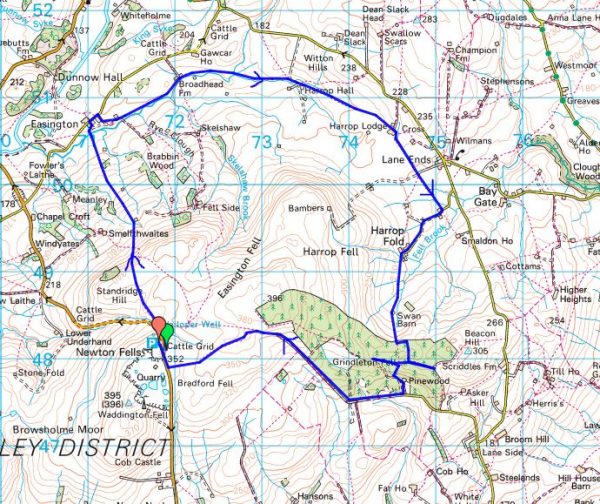
I planned to include Easington Fell into the round so I parked up at the top of the Waddington Fell road. I was the only car there on a misty morning and I hoped visibility would improve – it didn’t.

By the road side up here is Walloper Well.    Jessica Lofthouse (1976) described the place.

In the days of horse and pedestrian traffic none passed Walloper Well without stopping  to ‘quaff the clear crystal.’  Long ago, hill men, hunters, forest wardens and farmers off to Clitheroe markets and fairs, pedlars, lead miners from the nearby workings, all met here.  The name is thought-provoking. Why Walloper? From a word meaning a ‘fresh bubbling spring’, which this is, fresh from the moorside into stone troughs.  Age, wartime army practice and vandalism of 1974 made renewal of the trough necessary, but the flow has been constant.  One must drink, just as one throws pennies into the Roman fountain, to ensure one comes back again.”

So nothing to do with the frequently told story [very nonPC]  about the old man and his wife

Today there is no flowing water, I don’t know if this is the permanent situation.

After that disappointment I set off across the fell and immediately lost the path, if there ever was one. The ground was rough, what I call reedy walking, and you never knew if your feet would hit land or water.

Haircap Moss.

Persistence paid off and I spotted a cairn from where vague trods aimed to the barn shown on the map. From the hillside I could just make out Newton-in-Bowland, Easington and Dunnow Hall.

I was now on pleasant grasslands though this meant a herd of cows with accompanying bull. I was rather circumspect as was he. A teacher has just been killed near Richmond by cows.

Anyhow I arrived in to Easington unscathed and had time to look at the four dwellings making up the hamlet. The most interesting appeared to be the Manor House.
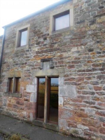
The Manor House.

I now followed the diminutive Easington Brook for a mile or so passing Broadhead Farm to Harrop Hall. On my approach to the latter the farmer shooed his herd of cows plus a large bull across the field for me to pass, a service I don’t normally receive. I realised at the remote Hall that I had visited before with a friend from Grindleton maybe 40 years ago to collect two kittens, Bonnie and Barnie I subsequently christened them. They were an adventurous pair climbing in through upper windows of my house and even venturing to the pub on the corner where customers fed them and returned them at closing time.

Harrop Hall.

Harrop Lodge was next, another building with interesting features including a Venetian window in the gable end and other bits of architecture.

Barn window.

Wall niche.

This stone footbridge took me into the wrong field from which it was difficult to extricate myself.At Harrop Gate I came out onto a little road through an isolated metal kissing gate.

200 yards up this road was Harrop Chapel with benches outside for my lunch stop. The chapel was built in the early 1820’s and has been in continual use since. It ceased to be Methodist in 1969 and now holds Evangelical services.

Refreshed I strolled up the road to the hamlet of Harrop Fold, only half a dozen neat dwellings. Of particular note is a large white house , an original C17th Lancashire Longhouse which provided accommodation for the family at one end and the livestock at the other. On the other side is the Manor House of a similar age.

So far the walking had been very rural but now I headed back up the fell past a barn and into Grindleton Fell Forest where my troubles started. The paths didn’t go where I thought they should and didn’t correspond to my map.  The trees limited visibility and the mist descended. I walked in many directions without finding my intended onward route. I was glad to hit upon a track heading out of the forest to join a lane prominent on the map. It was now easy to follow across the fell until I came out onto open moor once more. Up here the views back down to the Ribble Valley must be stunning on a clear day. Ahead of me was the vague outline of Waddington Fell with its mast acting as a beacon to aim for. By now it was cold and damp and I was glad to reach my car. I’d clocked up 10 miles.

Not many of you will have explored Harrop – ‘the valley of the hare’

*****

LITTLE BOWLAND VARIATIONS.

Little Bowland is the area west of the Hodder River below the Totridge fells. Limestone predominates giving springy turf to walk on. There is one minor road through the centre.

I often walk in this area but today, a hot sunny Sunday, I find some new paths and ascend a little hill previously missed. What follows is a rather dull description of this beautiful area.

I park near the entrance to Leagram Hall and walk up the lane through the park. As usual there are hundreds of sheep at Laund Farm, supposedly Blue Faced Leicesters. I take a track off to the right going over a hill to cross Leagram Brook at ParkGate farm where there has been a minor path diversion. Over more hills and down to Park Style which was being renovated last time I passed, there has been some progress but it looks unloved and deserted. So onwards to pass the buildings of Lickhurst and over a limestone knoll to Dinkling Green, another cluster of houses. Don’t they have some nice names around here. I usually continue further into limestone country from here but today walk down their farm lane until a sunken track takes me over a little col and down to that minor road I mentioned. I become distracted here by some crags just off the road. On closer inspection they are low and broken but there are some fine Maidenhair spleenwort ferns growing out of cracks.

Down the lane is a quarried reef knoll where there is some hard bouldering.

On reaching it I decide to climb the hill behind as there are no intervening walls as far as I can see. New Laund Hill a modest 229m. though what a fantastic view point it turns out to be. North up the Hodder towards the Trough Of Bowland and its surrounding fells, distant Pen-Y-Ghent, Waddington Fell and then down the Hodder to Longridge Fell and Chipping Vale.

By coming up this way I miss New Laund Farm and Fairy Hole caves. Through the interesting buildings of  Fair Oak, a barn has a date stone 1729, and on to Higher Greystoneley, my friends are out so I miss out on a brew.

I hardly recognised the next bridleway as most of the trees seem to have been cut down since the last time I was here.

There is another limestone quarry behind the prominent limekiln. I have a poke about and find some interesting faces which could be worth exploration.

I always have difficulty over the last stretch, there is a crucial bridge over Leagram Brook and I struggle to find it. I admire the mature trees in the park… … and contemplate the symmetry of Pendle and Longridge Fells.

I have only seen two people all day.

*****

NATIONAL ALZHEIMER’S DAY. September 21st. Finding a new path.


Over the last year I’ve been trying to find the right path to communicate with my lovely friend suffering from Alzheimers. While I could, I took her out to hopefully familiar places and friends. When her watch showed noon it was time to find somewhere to eat. Lager and lime, fish no batter, chips and mushy peas, was the order of the day.

Then we would play patience, she rarely missed a trick.

Then we would sit and do jigsaws, she had a quick eye for the right piece.

Then I would play music; The Beatles, Hot Chocolate and Niel Diamond. Was that the best choice?  A wave of the hands or a nod of the head meant a lot.

Then I would just talk about anything. A thumbs up was all I needed.

Then she stared, did she know me? Was that a tear?

Then she went.

***

After the funeral I went for a walk up Longridge Fell. It was a beautiful late Summer’s evening. I thought I had found a new path through the trees, maybe a gift to remember her by,  but it went nowhere.

It is National Alzheimer’s Day today, September 21st.

https://www.alzheimers.org.uk/get-involved/world-alzheimers-month

Have you thought of giving to their charity?


CLAUGHTON BRICKS, CATON FELL, THE PLAGUE AND THE LUNE.

I have lost my camera with this day’s photos on. When I say lost I mean I can’t find it but I’m certain it’s in the car or the house. After much searching it still hasn’t turned up. My mind’s not focused as it is the funeral of my best friend.

Yes, it has turned up under the carseat!

The day itself, a week ago, was brilliant.

As you drive through Claughton on the Kirkby Lonsdale road an aerial ropeway crosses above you carrying clay in buckets down from high on Caton Fell to the brickworks by the road. I’ve always been curious as to what’s at the top of the ropeway. The other end of the rainbow. Today I intended to find out and dragged Sir Hugh along for company.

We parked at The Fenwick Arms, sadly closed as a result of lockdown and other financial pressures. One of the many casualties.

A steady 1000 ft. ascent on a previously cobbled track with not much to see, Claughton Hall was hidden behind trees and Claughton Beck could be heard but not seen. Near the top we walked under the upper part of the ropeway. The buckets were trundling up and down by gravity feed. Constructed in 1924, this is the last gravity feed aerial ropeway operating in Britain. We crept into the upper quarry to see where the buckets were coming from – the answer was a shed where presumably the shale and  clay was loaded. There was a large quarry behind. We need not have trespassed as there are plenty of YouTube videos.

We came out onto the open moor near the wind farm and past the restored Moorcock Hall – certainly one of the remotest houses in Lancashire with a splendid view over Morecambe Bay.

A diversion was suggested to the trig point, 361m, of Caton Moor. We had walked past here on The Witches Way in 2016 without visiting the top. It was fairly barren up here but there were good views over the northern Bowland fells with the shapely ‘peak’ of Mallowdale Pike catching our eye, one for another day?  Ingleborough of cause made an appearance.

On the way back Sir Hugh spotted a couple of workers on one of the wind-turbine blades, I think I would have walked past without noticing. They must have abseiled down for some repair work which looked perilous from below.

I tried an arty shot with the juxtaposition of wind power against nuclear, Morecambe Power Station in the blurry background.

After the excitement we found a picnic bench for a civilised lunch stop. Two ladies on an adjoining bench were having a conversation where they both spoke at the same time.

The tarmacked lane down to Brookhouse went on for ages in the ever increasing heat of the sun.

Brookhouse is a charming olde worlde village which modern times and the main road have passed by. We were glad of a sit-down in the church yard where fresh cool water was found. St. Paul’s church dates from the !6thC. Built into the West wall is a Norman Arched doorway. Set into it are stones from former buildings, various Medieval marked stones. Rather a shambles really.

Whilst in the pretty village we had time to find the Plague Stone. Set into the parapet of the bridge next to the pub is a large stone with a hollowed-out top. In Medieval times plague epidemics killed thousands of people up to the late C17th. Victims socially distanced themselves outside towns but collected food from the stone. It is thought that the depression in the stone was filled with vinegar to act as a sanitiser for the coins left in payment. Does this all sound familiar in the twenty-first century?

A field path took us to the busy A683 which we crossed to get onto the disused railway line [Lancaster to KIrkby Lonsdale] this provides a cycle way out of Lancaster city centre but sadly comes to an end near here as far as public access is concerned. The River Lune curves elegantly through the fields and despite its attractiveness there is little in the way of a marked path. A lady was swimming in one of the pools; it looked very inviting in the hot sunshine. Ahead was Ingleborough with Hornby Castle prominent upstream. Fields separated us from the brickworks with the windmills visible on the moor above.

Heading back into Claughton we crossed the site of the old railway line at Gatekeepers Cottage. There was no sign of life at The Fenwick Arms.

On the drive home I stopped to take a photo of the aerial ropeway and its yellow buckets crossing the road, I now know where they come from.


*****

FAIR DAY ON FAIRSNAPE.

                                                         Looking back along the Fairsnape ridge.

JD and I set off from St Eadmer’s Church for a round of the Bleasdale fells. It was warm and sunny from the start. As is usual in these Covid 19 days we caught up with each other’s news and discussed the state of the nation as we walked up the estate road. Before long we were faced with the long rake across the side of the fell up to Fiendsdale Head, it seemed steeper than before. Drinks were taken half way up as we suffered from the heat.

The way onwards to the summit is always boggy but with a judicious choice of cloughs and some changing of sides over the fence we made it with dry feet. There are not enough flags.

We were kept entertained by a helicopter making repeated trips with some payloads to the distant White Moss. An even stranger sight greeted us we reached the 520m true summit of Fairsnape, a substantial digger perched on the peat hags.The operator was sat in the cab so we could ascertain his mission. United Utilities [North West Water to you and me] are trying to stop peat erosion and water run off. He evens out the cloughs, the helicopter drops stones to form a barrier before heather is replanted. Easy.

Stones emptied into the cloughs.

Well on a good day like today its good work but in a storm it would be a different matter. He spoke of trying to avoid the monster getting sucked into the peat. We left him to it but wondered at the effectiveness of man in such a huge scale of wild moorland.

The trig point, 510m, and cairn of Paddy’s Pole [no idea of its origin] on the western edge of Fairsnape are easy to locate in today’s clear weather but this area can be a nightmare in bad conditions and poor visibility. We both had tales of aimless wanderings.

In these conditions an easy stroll across to the trig and Paddy’s pole..

The shelter gave us a place to sit and eat lunch. I was on the lookout for flat soft areas for a future bivi night.

Along the ridge towards Parlick we were keen not to miss Nick’s Chair a lofty rocky prominence.

Nick’s chair – easy to spot in this direction.

Here is a 2014 picture of my grandson on the chair featured in one of my ‘lockdown’ quizzes.

We didn’t bother with climbing to Parlick’s summit but took a traversing path around it before descending the Zigzags down the rough fell side to Blindhurst.

Blindhurst with Beacon Fell in the distance.

Blindhurat Farmhouse.

It was then an easy walk across fields back to the church. A well devised route from JD. I believe I had a touch of sunburn.

The last time we did a similar route was almost 2 years ago to the day in Hurricane Ali, what a contrast.

*****

WHELP STONE CRAG – Gisburn Forest.

                            Distant view of Whelp Stone Crag peeping out of vast acres of Gisburn Forest.

I parked in Tosside; a church, a village hall, a war memorial in the middle of the road and an inn that is closed.

St. Bartholomew.

War memorial and ‘pub’


On the map the track leading to Whelp Stone Crag looked straightforward, a lane to a farm and then a footath alongside Gisburn Forest. As far as the farm the lane was good but the path onwards diabolical, difficult to follow on the ground, encroaching trees and waterlogged for most of its length. Why do I always seem to find these horrors?  I could hear the mountain bikers on the Gisburn Forest trails whooping with delight, I hope they could not hear my cursing. I would not recommend this approach, there are probably better traks within the forest.

The crag in sight over more rough ground.


Anyhow I arrived at the trig point, 371m, on top of a fragmented gritstone edge. Ravens were cavorting about in the updrafts. There must be some good bouldering on these rocks. From here I could look down on the bikers speeding along the trails. There were 360 degree views over Pendle, Bowland and into Yorkshire although the higher peaks were cloud covered. I was the only person up here.

After a snack as I was preparing to leave a couple arrived on the summit. ” That was the worst path we have ever been on” was their opening conversation. I had no idea what they meant.

The ongoing ridge was a delight before trackless slopes took me down to squelshy fields where farmers were rounding up their sheep. Across the valley, A65, were the limestone hills of the Settle area.

The unmarked footpath just about navigated me through or around, I was never sure which, several farms called Brayshaw. They all had a well worn look to them and were undoubtably of vintage.

Passing a smarter residence I reached some tarmac on a minor road. I threw in the towel and followed it back to Tosside. I think I was in Lancashire most of the afternoon but the oulook was Yorkshire Dales country.

*****

LONGRIDGE SLATE POETRY – Dark clouds gathering?

On many of my local walks up on Longridge Fell since the pandemic started I highlighted the uplifting poems written on slate and scattered about the region. I still do not know the originator of these pieces of art. Each one has been chosen for its content – nature and the environment; humanity, compassion and hope.

Today I have a stroll around the village itself to discover even more poems.

When I wrote about Longridge in March it was virtually a ghost town, but time has moved on, we have relaxed and ventured out shopping again. The coffee shops have a new lease of life. Today in the blue sky and sunshine the streets were busy, but with many people wearing their masks between shops. A new normal as the infection rate rises?  The virus’s hand is on our shoulder warning us of a bleak Winter to come. In that context the poems take on a life of their own – interpret them as you wish, but we should embrace  their optimism.

The latest slates in no particular order…

There may be more painted slates lying unnoticed in the village, I’ll keep looking. I think we may need their solace in the months to come.

On my walk I had a song constantly nagging at my mind …

RIVER WENNING AND ‘THE BIG STONE’.

The River Wenning comes out from the Craven limestone dales and heads towards the Lune.  Today we were constantly reminded of the Dales by the presence of the Three Peaks on the horizon. The river takes its name from the old English ‘wan’ meaning the ‘dark one’ and within yards of the carpark we were crossing its rushing brown waters. These waters in the past powered mills in the Bentham area, originally for flax but later turning to cotton and silk. Here at Low Bentham modern accomodation has been developed in some of the old buildings.

It was a pleasure to walk upsteam chatting to Sir Hugh especially after the last few stressful weeks. Before we knew it we were in a massive caravan park, part residential and part tourism. We were impressed as to the quality of the park but what would you do here all the time.

After exracating ourselves from the park we climbed little used paths linking farms up the side of the fell. Some tidier than others.

Fourstones Farm

Once on the open fell the object of our walk appeared on the horizon across boggy terrain. The Great Stone of Fourstones stands on the Lancs/Yorks boundary. Known locally as ‘the big stone’, it is a glacial erratic gritstone. Originally as the name suggests there were three others which were broken up by farmers, but I can find no reference as to any dates or why one stone survived. A feature of the stone is a set of worn steps carved into the side, easier to climb than descend. I remember playing here with my children and finding more adventurous ways to the top. Today we were entertained with an ascent by a passing motorcyclist in his unsuitable footwear. The stone is covered in carved graffiti.

Leaving here we weaved a way across the fell to descend past interesting farms with the dramatic view of the Yorkshire hills ahead of us.

Gragareth, Whernside, Ingleborough and Penyghent.

Grusckham.

A late lunch was taken sat on a couple of stones only to pass a perfect wooden seat within a hundred yards. This is a frequent occurence on walks which remains an unexplained quandary.

Dawson.

From time to time we were strafed by Chinook type helicopters which had the conversation ranging to ‘Mash’ – Hawkeye, Hot lips and Radar. We are of a certain generation.

Back on the River Wenning we bypassed Higher Bentham village using a lane by riverside mill cottages. Once through another large caravan park we took paths on the north side of the river to Lower Bentham.

Sleepy Lower Bentham.

Yet another interesting walk in unfamiliar territory. Are there more in this area?

*****


LITTLEDALE. A bittersweet day.

                                                                   Bowland at its best.

I walked here a week ago, August Bank Holiday Monday. We had planned it to avoid the crowds. Sir Hugh’s write-up is already published.

On my drive home I had a phone call to say my friend with dementia and motor-neurone disease had suffered a turn for the worse. Was I glad I had not taken the motorway, it was jam packed. My little car sped through the by lanes and I arrived along with the paramedics. There was little they could do except offer sincere empathy, likewise the on call doctor who came shortly afterwards. Thankfully she could be nursed, unconscious, at home. Two days later she passed away peacefully. I’ve lost two of my best friends this year.

A week later I have loaded my photos but am unable to give a  commentary.

Baines Crag carpark.

Artle Beck.

Crossgill Farm, 1681, typical of the area.

The former St. Anne;s Chapel. 1752.

Littledale Free Church, 1849, now a store.

Littledale Hall and buildings, C19 gothic style. Now a ‘therapy centre’.

Sir Hugh entering upper Littledale.

Leafy Littledale.

Over to Roeburndale – another day.

Littledale – there and back.

I want one of these when the time comes.

Littledale Hall again.

Caton Moor wind turbines.

Slopes of Clougha with the infant River Condor.

Looking back towards distant Ward’s Stone Fell.

Baines Crag.

A steep end to the day.

*****

ALZHEIMER’S DISEASE – a personal view.

Covid Lockdown. I’ve not been for three months. She must wonder where her friends have gone. What’s app video conversations have been intermittent and unsatisfactory. But I’m looking at it from my perspective, maybe she loved to see my face on the small screen, I certainly had the thumbs up even when there was no speech left.

At last, I can visit in the garden. As I walk in front of the windows up goes the thumb, only one now. How wonderful.

The combination of her deterioration and the Covid lockdown has not been good so I’m overjoyed with whatever recognition there is. There are stories everywhere of family’s unable to be close to their loved ones in life and death. All heartbreaking.

Dementia is cruel and insidious. Maybe two years ago there were early signs, slightly odd comments but we laughed them off. Then it was all too obvious but we kept on with life as much as possible. Even last September a holiday at their house in France. Old haunts were reassuring, maybe for her but helpful for us.

The trips out in the autumn to pubs for lunch. A finger pointing at her watch when the hour was twelve – they were serving food.  Signs language told me, if not the waitress, fish, no batter, chips and mushypeas. Maybe room for apple pie and custard. Some establishments were more understanding and accomodating than others. I’ll patronise those again when the pain is over.

But now a bare six months later there is only a glimer of recognition, a stare and possibly an attempt at a thumbs up. And now a stare

I talk and gesture almost a dementia in myself, thats all I have. A stare

I dread tomorrow, if she is not in the familiar chair.


ANOUSHKA SHANKAR.

Following on from a post by Sir Hugh [ http://conradwalks.blogspot.com/2020/08/the-first-night-of-proms.html ]  this is why I pay my TV license. 

I’ve just watched/listened to a brilliant display of sitar playing by Anoushka Shankar, daughter of the legendary Ravi Shankar on BBC Four, part of their Proms season. There was no audience this year because of  Covid 19.

The first session was with an electronic mixer Gold Panda twiddling the nobs. Mind blowing, you just have to listen to it.

The second session was with a strings orchestra and Manu Delago playing the Hang drum, which looks like a wok. Inspirational.

I hope it will be still visible on catch up TV  – if you have paid your license.

https://www.bbc.co.uk/events/erfz3d

https://www.bbc.co.uk/iplayer/episode/m000m7gz/bbc-proms-2020-anoushka-shankar-and-gold-panda


HAVE YOU BEEN TO LOWGILL? THE FAR SIDE OF BOWLAND.

This all happened a few days ago. I’d driven up the minor road from Slaidburn which heads over the hills to Bentham. As I crossed the watershed at the Cross of Greet I became aware of the vast landscape ahead of me. The Yorkshire peaks of Ingleborough and Whernside, the Barbon Fells and the distant Lakes overlooked a barren landscape of upland moor. There is nothing but sheep up here and they tend to sit on the road creating an additional hazard. I’m on my way to meet up with Sir Hugh whom I’ve not seen for 6 months due to Covid problems.

From the Taham Fell road, there is a turning to Botton Head, a culdesac, more of that later and then a sign to the mysterious Lowgill. I drove down the steep narrow lane hoping nothing would come the other way. We have arranged to meet in the village near the school where parking is just possible.

We had an idea of a route up and down the valley of the Hindburn River using paths and lanes.

The paths turned out to be little used and finding the bridges to cross the numerous streams became a challenge. The first path took us up to the little Church of the Good Shepherd, erected in 1888 by the Lancaster church architects Austin and Paley. Well named as these Tatham Fells are home mainly to sheep.The road leading up to it was 1in4 with an acute bend which must make attending Sunday service in an icy winter exciting.

The Hindburn was running high and the water was the colour of a well-brewed Pekoe tea. The way we chose ran alongside for a while. The name, as in neighbouring Roeburndale, is from the deer that roamed these parts in large numbers. I imagine there will still be a few about when you are not looking, as are red squirrels apparently.

We were in pathless sheep pastures with the occasional old barn helping navigation, distant Ingleborough kept popping up on the horizon.

For a while we walked alongside the River Hindburn.

Lower Thrushgill was the first inhabited house we came across, tastefully restored from its 1798 origins. At one point the path going by it seemed to head straight into their conservatory. Out on the lane we met up with a friendly deaf and mute man clutching a poorly photocopied map of the area, we helped him on his way by pointing out hopefully the correct route. He was the first person we’d seen all-day but shortly afterwards we met a lady and boy with their dog. The boy had been bathing in the river – simple pleasures reminiscent of my own childhood.

Approaching Botton Head.

We crossed the river and walked up to Botton Head Farm at the head of the valley. This old farm dating from the C17th is at the end of that culdesac road I’d notided on my drive over. The farmer, had he seen us coming? emerged for a chat which pleasantly gave us some history of farming in the area and more. He had lived here all his life and seen most of the surrounding farms abandoned and bought for restoration as country residencies. The land becomes rough, suitable only for sheep and the scattered barns no longer needed. A dying breed. At least he put us on the right track for a lost bridleway which had us searching for stiles and bridges. A magic spot by a side stream served lunch in the sunshine.

The lost ways were ‘followed’ to a farm building strangely named Swans and then a track to the road at Ivah. Here we met up with the lady and her dog, now much friendlier [ the dog that was] and coming down the lane a jubilant walker doing sign language. He had completed his circuit, thankfully our earlier directions had proved correct and helpful. Despite his limitations, we made out that he was ‘buggered’ from the day’s exertions. We weren’t that tired as we strolled down the lane to the few houses that make up Lowgill.

An impressive marble monument was in a prominent position by the road remembering four souls lost in WW1.

Until 1960 there used to be a public house here, The Rose and Crown, this may have been it…A lot of the houses had collections of presumably local stones from the fields. They looked like tortoise shells and felt heavy. I need to correspond with ‘the Rockman’ for their origins – he came up with name  ‘septarian nodules’. Concretions of sedimentary rock and minerals from the Cretaceous seas 50 – 70 million years ago.

So our six-mile exploration of this hidden Bowland valley had been a complete social distancing success. We parted with ideas of another equidistant meetup and walk in the near future.

My quandary was whether to take the easy option of going north to link up with the motorway home or go back over those lonely hills. The latter won so it was topdown for a road trip as good as anywhere in England.

Barbon Fells, Whernside and Ingleborough.

Cross of Greet road


Distant Pendle.

Source of the Hodder.

Roman road from Newton.

THE OTHER END OF THE FELL.

                               Longridge Fell from the south, Kemple End is the steep bit at the right.

The fell in question is Longridge Fell, may I remind you it is the most southerly named ‘fell’. It rises to all of 350m and is a 6 miles long escarpment with a steep northern side and a gentler southern slope. The town of Longridge sits at its western end. My recent, infrequent, walks have been at the western end so today I explore the eastern end above Hurst Green where it drops steeply to the River Hodder. I have a particular path I want to explore.

I start in Hurst Green near the Shireburn Almshouses, they were first built in a commanding position on Longridge Fell itself in 1906 but were moved and rebuilt in Hurst Green in 1946 for Stonyhurst College workers.

Hurst Green Almshouses.

I set off on one of my favourite paths that goes alongside Dean Brook which has found its way down from the fell and here is in a little gorge where it was harnessed to provide bobbin mills with power. Today, after last night’s rain it was flowing energetically through its twists and turns. Alongside is Sand Rock an old quarry which I diverted to see. I have climbed here in the past but it tends to be damp and green. There is a good view of the bridge from up here.

The lane leads on past Greengore … … an old hunting lodge, and heads gently up towards Longridge Fell which on this slope is covered extensively with forestation. At the road I go left to pick up the forest track going higher onto the fell. It was near here that a fire broke out recently due to those dangerous disposable barbeques and their idiotic owners.

A sidetrack leads up onto the ridge where you pass through a wall stile to sudden extensive views; Chipping Vale to the Bowland Fells, Beacon Fell and the Fylde coast leading to Morecambe Bay and distant Black Coombe. A short boggy walk by the wall brings you to the summit Trig point, Spire Hill. There are usually a few people wandering around up here. Now out northeast are the three Yorkshire Peaks.

Heading eastwards I soon enter the dark forests where paths remain wet throughout the year. Further, on Hare Hill, is an area of older Scots pines I call the enchanted forest, where paths seem to disappear amongst the shapely trees draped in moss. I’ve bivied up in this spot several times, magic evenings with owls hooting and deer wandering by.

I emerge onto a forest track which leads to an open area with views this time into the heart of the Trough of Bowland whilst way down below are scattered farmsteads. There are some logs to rest awhile.

In the sunshine butterflies, mainly Red Admirals, flit about the purple heather which is just coming to its prime.

Onwards is a much smaller path in the trees on the edge of the steep northern scarp, the land just drops away from you. When I first explored these forests 50 years ago there were no paths at all, but over time this one has become established and now appears as a dotted line on the 1:25,000. In recent years with the advent of mountain bikes, a lot of tracks have become badly eroded – my feet are certainly wet by now.

As this narrow track, now hemmed in by young spruce trees, starts to drop down the fell end I’m on the lookout for that public footpath I want to explore. It drops down back NWesterly on an old rake. At one time this was through mature trees but these were felled a few years ago, I’ve not used it since. There is little sign of it amongst the new growth and I have to take a GPS reading to determine where it starts, there are vague traces of it so I build a stone cairn to mark the spot.

SD687408

As I go downhill the now reedy rake becomes more discernable but difficult to walk on. It needs more traffic but most don’t know of its existence so I’ll report it in the hope of some maintenance by the forestry people, they should have reinstated it soon after their felling operations.

Coming down to the forest edge a stile allows me to walk along an old sunken, and boggy, track. There is a bench here remembering a Liverpool hiker. I stop for a snack looking out over the peaceful Chaigley countryside with old friends Waddington Fell and Pendle in the haze. I imagine how the man must have enjoyed his trips to this part of the country escaping the urbanity of his home city.

Sir Hugh will be pleased to read that my next destination after Turner Fold was Kemple End. Here I wander past the cottages to reach a path going down the fell. This path follows the line of an old sledge way used for taking stone down from the quarries here to Hurst Green for the construction of the Shireburn family’s great hall which became Stonyhurst College. On a whim I decide to take an unknown, to me, footpath leading more directly down the fields. I come out by a delightful farmhouse, Throstle Nest, tucked away from society. The owner is strimming his verges, I stop for a chat and to compliment him on his residence. I’m the first person he’s seen on the path for months. He laughs that last weekend he travelled to the Dales to climb Great Whernside but the car parks were packed and the Covid hordes all over the hills. He won’t be leaving his Lancashire haven again during the viral pandemic. Of course, we then get to pontificating on when and how it will end so I forget to take a picture of his house but his view is good.

The public footpath goes through an unusual squeeze wall and straight across the front of the Stonyhurst College giving up-close views of the architecture and a vista of the ponds and straight drive in the reverse direction.

By the church which is unfortunately closed, I have my next ‘virus’ conversation with a mother and daughter. The daughter is reading philosophy and French at Oxford and is due to start her year abroad in Nantes. The uncertainty of the pandemic is giving her a few extra worries.As there was nobody around I took the opportunity to have a look at the old mill restoration. It dates back to 1840 when it was powered by water from the ponds for flour milling. Later in the C19th a steam engine was installed. Last time I passed it was falling into disrepair but has since been fully restored to function as a retreat centre. Apparently there are remains of a fives court which I missed.

The field paths back to Hurst Green are busy as I’m now on part of the Tolkien Trail. It is conveniently thought that J R R Tolkien, whilst staying at the college where his son was a pupil, may have used the local countryside as inspiration for his popular Lord of the Rings. You enter into the village past some pretty cottages,

I have enjoyed this splendid outing showing some of the best scenery in this part of Lancashire and have gone into more detail than usual in the hope that some of you will be tempted to visit but maybe keeping to the well worn tracks.

Another version of this walk in reverse and including a bit of the Hodder is here.

*****


LONGRIDGE FELL ANTIQUITIES.

                                                                            Thornley Hall Fell Cairn.

I’ve not been for a walk for a couple of weeks – too busy posting about Hen Harriers.

Part 1.

It was good to get out today with JD for a gentle stroll up Longridge Fell. It needed to be gentle in view of my physical state and the oppressive heat we are experiencing. By the way, we are not the antiquities in the title.

We follow the usual track up from the parking at Cardwell House, there are stone marker posts, but instead of taking the panoramic path overlooking Chipping Vale I suggest we carry straight on to look for a cairn circle marked on the map and mentioned in online sites.

At the place marked on the map all we found was a modern pile of stones [red dot on map] with no evidence of a circle, which is often the case.

Thornley Hall Fell Cairn.

So on we went and now off track managed to fall foul of some boggy areas just as JD was praising his trainers and saying how waterproof they were or as it turned out weren’t. The trig point on Spire Hill looked as though it had been recently repainted a very bright white, for a short period a few years ago it was a lurid yellow. Views were hazy. We walked on through the trees and onto the familiar forest tracks catching up on each others news whilst we had been in lockdown. A pleasant couple of hours but a failure on the antiquities exploration.*****


Part 2.

A liittle more research online –  https://thejournalofantiquities.com and https://www.megalithic.co.uk – and I was ready for another walk up the fell with the sole purpose of tracking down the circles.

Jeffrey Hill Cairn Circle.

Jeffrey Hill Cairn Circle. SD64444045 200 yards NE of the car park there is a Bronze Age cairn circle which is not marked on the OS map. It is a circular feature of loose stones, some of which have been placed here in more recent times. Sadly, the site has become overgrown with heather, but in all it measures between 25-30 feet in diameter. Close to the remains of the cairn circle there is a rectangular earthwork. This was perhaps an entrance (portal) to the site. It is very difficult to make out.

Thornley Hall Fell Cairn. SD64524047 A little further away, in the same direction and close to the Roman road to Ribchester, are traces of hut circles together with a tumulus/burial mound, now difficult to see at ground level.

I arrived back at the pile of stones marked on the map and pictured above which I now think corresponds to Thornley Hall Fell Cairn.

I traced my way back through the rough ground until I was at the correct grid reference for Jeffrey Hill Cairn Circle and found the stones depicted on the websites. It was impossible to make out any circle.

                                                   Jeffrey Hill Cairn Circle.

Across the fell in a NE direction I could see a metal fenced enclosure which I’d visited before but thought deserves another look. It appeared to be Victorian style fencing with a tumbled gate leading into a 12ft by 10ft empty space. I can find no reference to this structure apart from an oblique mention of locked gate to a beacon. I would have thought that any beacon would have been higher on the fell. I walk back none the wiser.

*****

*****

That was the finish to my short visit to this end of the fell but for the sake of completeness I’ll mention another antiquity at the Eastern end, near Kemple End – the  Anglo Saxon cross sometimes known as the Paulinus Cross which I visited recently.


“STOP GROUSE SHOOTING’S WAR ON WILDLIFE”

I hope this will be my last post for now on the ills of the grouse moor. I’ve recently tried to highlight raptor persecution and today want to bring to your attention the vast losses of other wild life occuring on grouse moors. The more the public become aware of these killings the more the pressure on politicians. So read the article, spread the news and sign the petition.

Hundreds of thousands of innocent animals – foxes, stoats, weasels, and hedgehogs, as well as birds are killed in traps and snares on Scottish grouse moors every year. This is having a massive environmental impact as these moors cover a fifth of the land in Scotland. The same is happening in the rest of the UK.

The League Against Cruel Sports have just published an article  with a link to the full report.

There is a petition to sign here.

A recent article in The Yorkshire Times by David Goff is worth reading. https://yorkshiretimes.co.uk/nature

It’s time I got out to do some some walking…

43 HEN HARRIERS MISSING SINCE 2018.

There is a petition for you to sign at the end of this post.

I wrote a few days ago about Hen Harrier Day and I hope some of you may have had a chance to watch part of the virtual presentation on YouTube. There were some excellent videos of Hen Harriers in flight and their courting display. Amongst the many features of the programme, several respected environmentalists added to a balanced debate on Raptor Persecution over grouse moors. I would imagine there will be footage available on YouTube if you missed it.

Moving on, I received a post today from Raptor Persecution UK, a rather polarised group, from which I have extracted the following factual information which I present without comment. It is a list of Hen Harriers, mainly tagged, that have disappeared or been confirmed killed since the beginning of 2018.  Other Raptor deaths have not been included.  

It makes a depressing read.

***

February 2018: Hen harrier Saorsa ‘disappeared’ in the Angus Glens in Scotland. The Scottish Gamekeepers Association later published information claiming the bird had been re-sighted. The RSPB dismissed this as “completely false”.

5 February 2018: Hen harrier Marc ‘disappeared’ on a grouse moor in Durham.

9 February 2018: Hen harrier Aalin ‘disappeared’ on a grouse moor in Wales.

March 2018: Hen harrier Blue ‘disappeared’ in the Lake District National Park.

March 2018: Hen harrier Finn ‘disappeared’ near Moffat in Scotland.

18 April 2018: Hen harrier Lia ‘disappeared’ in Wales and her corpse was retrieved in a field in May 2018. Cause of death was unconfirmed but police treating the death as suspicious.

8 August 2018: Hen harrier Hilma ‘disappeared’ on a grouse moor in Northumberland.

16 August 2018: Hen harrier Athena ‘disappeared’ on a grouse moor in Scotland.

26 August 2018: Hen Harrier Octavia ‘disappeared’ on a grouse moor in the Peak District National Park.

29 August 2018: Hen harrier Margot ‘disappeared’ on a grouse moor in Scotland.

29 August 2018: Hen Harrier Heulwen ‘disappeared’ on a grouse moor in Wales.

3 September 2018: Hen harrier Stelmaria ‘disappeared’ on a grouse moor in Scotland.

24 September 2018: Hen harrier Heather ‘disappeared’ on a grouse moor in Scotland.

2 October 2018: Hen harrier Mabel ‘disappeared’ on a grouse moor on the edge of the Yorkshire Dales National Park.

3 October 2018: Hen Harrier Thor ‘disappeared’ next to a grouse moor in Bowland, Lancashire.

23 October 2018: Hen harrier Tom ‘disappeared’ in South Wales.

26 October 2018: Hen harrier Arthur ‘disappeared’ on a grouse moor in the North York Moors National Park.

1 November 2018: Hen harrier Barney ‘disappeared’ on Bodmin Moor.

10 November 2018: Hen harrier Rannoch ‘disappeared’ on a grouse moor in Scotland. Her corpse was found nearby in May 2019 – she’d been killed in an illegally-set spring trap.

14 November 2018: Hen harrier River ‘disappeared’ on a grouse moor in the Nidderdale AONB. Her corpse was found nearby in April 2019 – she’d been illegally shot.

16 January 2019: Hen harrier Vulcan ‘disappeared’ in Wiltshire close to Natural England’s proposed reintroduction site.

7 February 2019: Hen harrier Skylar ‘disappeared’ next to a grouse moor in South Lanarkshire.

22 April 2019: Hen harrier Marci ‘disappeared’ on a grouse moor in the Cairngorms National Park.

26 April 2019: Hen harrier Rain ‘disappeared’ on a grouse moor in Nairnshire.

11 May 2019: An untagged male hen harrier was caught in an illegally-set trap next to his nest on a grouse moor in South Lanarkshire. He didn’t survive.

7 June 2019: An untagged hen harrier was found dead on a grouse moor in Scotland. A post mortem stated the bird had died as a result of ‘penetrating trauma’ injuries and that this bird had previously been shot.

5 September 2019: Wildland Hen Harrier 1 ‘disappeared’ on a grouse moor nr Dalnaspidal on the edge of the Cairngorms National Park.

11 September 2019: Hen harrier Romario ‘disappeared’ on a grouse moor in the Cairngorms National Park.

14 September 2019: Hen harrier (Brood meddled in 2019, #183704) ‘disappeared’ in North Pennines.

23 September 2019: Hen harrier (Brood meddled in 2019, #55149) ‘disappeared’ in North Pennines.

24 September 2019: Wildland Hen Harrier 2 ‘disappeared’ on a grouse moor at Invercauld in the Cairngorms National Park.

10 October 2019: Hen harrier Ada ‘disappeared’ on a grouse moor in the North Pennines AONB.

12 October 2019: Hen harrier Thistle ‘disappeared’ on a grouse moor in Sutherland.

18 October 2019: Member of the public reports the witnessed shooting of an untagged male hen harrier on White Syke Hill in North Yorkshire.

November 2019: Hen harrier Mary found illegally poisoned on a pheasant shoot in Ireland.

January 2020: Members of the public report the witnessed shooting of a male hen harrier on Threshfield Moor in the Yorkshire Dales National Park.

1 April 2020: Hen harrier (Brood meddled in 2019, #183703) ‘disappeared’ in an unnamed location, tag intermittent.

5 April 2020: Hen harrier Hoolie ‘disappeared’ on a grouse moor in the Cairngorms National Park.

8 April 2020: Hen harrier Marlin ‘disappeared’ on a grouse moor in the Cairngorms National Park.

21 May 2020: Hen harrier (Brood meddled in 2019, #183701) ‘disappeared’ on a grouse moor in Cumbria shortly after returning from wintering in France.

27 May 2020: Hen harrier Silver ‘disappeared’ on a grouse moor on Leadhills Estate, Scotland.

Nobody has been prosecuted for any of these cases.

***


If you’re are concerned by the illegal raptor persecution on grouse moors please send a pre-written letter to your MP urging action. All you need to do is add in your postcode.

Launched on Saturday by Wild Justice, RSPB and Hen Harrier Action, over 29,000 people have signed up so far, meaning that 29,000 e-letters are on their way to our parliamentary representatives. Please join in HERE

https://wildjustice.eaction.org.uk/saveourskydancers

https://raptorpersecutionscotland.wordpress.com/

Thank you.           PS  It is the 12th August tomorrow, the start of the grouse shooting season.


RAPTOR ON THE LAWN.

Most days I see a Sparrow Hawk flying through my garden scattering the smaller birds and sometimes disappearing with a tit or sparrow. Yesterday as if on cue, it was Hen Harrier Day celebrating our raptors – https://www.henharrierday.uk/ I noticed out of the corner of my eye a pile of feathers on the lawn and a Sparrow Hawk devouring its prey. I hastily gathered my phone and took a few shots through the kitchen window and then it was away. The feathers, there was nothing else left, were possibly from one of the collared doves that frequent the garden.

Longridge is being built up with many green spaces, hedges and trees disappearing. This will have a marked effect upon the local wildlife. Within a couple of weeks, as well as the usual birdlife I’ve watched a hedgehog walking across the lawn and now a Sparrow Hawk. I wonder for how much longer will I witness these events?

HEN HARRIER DAY Saturday 8th August 2020


 I would like to draw your attention to the event below.

 Hen Harriers and other raptors have been persecuted for years and our local Bowland Hen Harriers have all but disappeared when once they were a regular sight. Grouse moor [mis]management has been implicated in their demise.

  Several organisations have been trying to highlight this problem and seek some better legal protection for our magnificent birds of prey. One such group, Hen Harrier Action, have staged events in the last few years to bring this to greater public attention.  This year due to Covid they have had to change plans and go virtual online. The details for their YouTube presentation is included below – it sounds an interesting and informative agenda and I think many of you could fruitfully dip into it.


It’s Hen Harrier Day this Saturday (8th August 2020) and this year it’s going online. Although we’ll miss the physical annual gathering at venues up and down the country, this year there’s actually far more scope to reach a huge audience, many of whom may previously have been unaware of the scandalous mismanagement of the UK uplands.

https://henharrierday.uk/online
https://www.youtube.com/HenHarrierDayUK

IS THERE LIFE ON MARS?

Today or was it yesterday, accompanied by the appropriate fanfares, a space mission has been launched from Cape Canaveral due to reach Mars in February 2021. Onboard is the Perseverance Rover.

According to NASA, the Perseverance Rover has four objectives supporting the program’s science goals:

Looking for Habitability: Identify past environments capable of supporting microbial life
Seeking Biosignatures: Seek signs of possible past microbial life in those habitable environments, particularly in special rocks known to preserve signs of life over time
Caching Samples: Collect core rock and “soil” samples and store them on the Martian surface
Preparing for Humans: Test oxygen production from the Martian atmosphere

That all sounds wonderful and I’m the first to support scientific research to help mankind into the next century and beyond. None of us knows where these experiments may lead.

However, we may not get the results until halfway through the present century. The cost is billions.

So let us not lose sight of the fact we are in the middle of a viral pandemic which may yet destroy our civilisation. Earth is, again let’s not forget, experiencing global climate changes threatening to destroy our civilisation. Where is the resolve and expediency to solve those two problems? Politically we have failed to heed the medical evidence for the former and internationally we have all but given up, despite the diminutive Greta Thunberg, on the latter. Depressing thoughts I know.

So today’s news of the Mars probe doesn’t fill me with joy as it should. I’m not certain how the possible advances in science in 40 to 50 years will bring us back from the present catastrophe of our own making.

*

This morning a hedgehog wandered across my lawn, the first I’ve seen this year. Apparently, they are in serious decline. If we can’t protect this wonderful creature what is the point of going to Mars. 

So I’d like to re-phrase that question.  Is there life on earth?

*

And obliviously I can’t resist the girl with mousy hair – but maybe we will never know.

STOCKS RESERVOIR – THE OTHER WAY ROUND.

Last week my planned trip to Stocks was aborted by a last-minute decision to walk up Croasdale. I was back today though and parked at a remote spot on the hill road from Slaidburn to Bentham just short of the Cross of Greet bridge over the River Hodder, yes I renew my acquaintance with this lovely river. The Hodder Valley up here was dammed in the 1920s to create Stocks Reservoir.  For an informative history, http://www.dalehead.org/ is worth consulting.

As is usual with my walks at the present I don’t set off till lunchtime when the weather is hopefully on the mend. Where I park, avoiding the busy honeypots, gives me easy access to the waymarked circular walk around the Reservoir. Incidentally, my last visit here with Sir Hugh and JD was last July almost to the day. That was a bright sunny day whereas today was dull and windy and I decided to walk anticlockwise for a change.

Immediately I was inserted into a procession of walkers who were already halfway round. It’s a busy Sunday. Behind me, a commotion erupted as a couple with a dog off the lead, despite all the notices, were frantically calling its name, Max, as it charged off after the sheep. They charged off after the dog and all ended up in a heap on the hillside, I had no sympathy and walked on.

The route I was walking was originally a rail track from a quarry providing stone for the dam. It took me past the fishermen’s cafe and centre, where I couldn’t resist a coffee, served with all the Covid precautions we are having to get used to.

Onwards past the stately mansion built by the waterboard.

From the dam I watched fishermen stood in the water or more sensibly sat in a boat, not a fish was landed.

After that were open meadows with views up the water. I would think it was fifty-fifty as to the number of walkers going my way and those completing the circuit clockwise. I’ve often debated on how we choose the way around a circular walk – prevailing weather conditions, the best views, ease of ascents, the guidebook description etc. I wonder if left-handers have a different mindset? Whatever my circuit today gave different aspects to previous visits.

At the road, I met all the mountain bikers spilling out of Gisburn Forest and all the cars parked in and out of the car park. The lockdown has highlighted selfish and illegal parking.

Once past the parking I had the trail to myself once again giving me time to nibble away at the abundant wild raspberries. United Utilities have done an excellent job of keeping us walkers off the road on a permissive path that has a good feel as it winds through the bushes.

Occasional walls remind one of the previous village that occupied this valley. I popped into one of the bird hides along here but not much was happening, cormorants were drying their wings on a promontory on the far side of the water and a kestrel was hunting closer by.

A steady pull up a lane brought me to the site of New House farm of which there is only a barn still standing, the web site I mentioned has photos of the old farms. Great views back down from up here over Stocks with Pendle in the distance.

I’m almost full circle but first, have to drop down to cross the footbridge over the River Hodder and climb up on a flagged path past more ruins to where I am parked.

Here I bizarrely meet a young lady with a baby in a pram and a couple of working dogs. , “He was teething so I’ve come out to settle him”,   She lives just up the lane in one of the most remote farmhouses in Lancashire, it was Yorkshire once. She bemoans the fact that the area is becoming more accessible and well known. there are even boy racers on the road.

*****