Category Archives: Cicerone’s Lancashire Walks.

CICERONE’S LANCASHIRE. ROEBURNDALE – a walk on the wild side.

P1050075

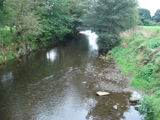
I find myself walking along a slippy rocky ledge just above the fast flowing River Roeburn. I have long since lost the path if ever there was one. Then it all stops at a steep landslide. Go back or try to climb out into the woods above.  Chapter 8, of Cicerone’s Walking in Lancashire, ‘The Enchanted Valley’ of Roeburndale had promised so much.

I have battled with the paths down here before. This time coming in from the south with detailed instructions from the guidebook it should be a doddle. I’ve had my lunch in the little Methodist Chapel at Lower Salter and I find the ladder stile into fields above the Roeburn. There are helpful ‘Concessionary Footpath’ signs although for some reason a map presumably showing them has been vandalised. The vague path keeps above the gorge and its trees until a way down is found to the river at a footbridge I recognise. But the guide says “remain on the west bank”. I try to but the path just disappears in the undergrowth and tree cover. I retreat to the footbridge and try the east bank. P1050139

P1050146

P1050153P1050155P1050156

A path comes and goes, I ignore the obvious path we had descended from this side to get here last time.  I battle on by the river hoping a better path may appear, but it doesn’t. I enter a rocky gorge and spot a vehicle ford across the river. Awkward side streams need careful attention. There are some footbridges but with their wooden slats missing, presumably only in use in season by the shooters or fishermen. I don’t know where they lead to anyhow, so I don’t risk crossing them commando style. There is even a pulley cage across the torrent a little farther on, I certainly wouldn’t risk that. There was a serious accident near here in January 2022 involving an all-terrain vehicle pulling a trailer when a bridge gave way

P1050157

The last post.

P1050168

P1050161P1050159

P1050162

P1050164

P1050165

P1050172

Maybe I should turn back, but my stubbornness drives me on hoping to find a way that might correspond to the guidebook. The gorge deepens and my only way of progress is at the water’s edge on those slippery rock ledges just above the water. I even contemplate walking in the shallows but they are fast-flowing. This is the river that flooded in 1967, taking out all the bridges and demolishing many cottages downstream at Wray. P1050169P1050170P1050173

The camping bothy appears on the other side, it’s marked on the map so I know where I am. But the landslide looms ahead and this is where I realise my best way of escape, not necessarily the safest, is to climb the couple of hundred feet up a steep bank above me, knowing there are paths along the top edge of the woods.P1050174P1050175

It is steep and slippery and I make frequent use of tree roots, clumps of grass and my knees on my slow progress upwards. Not a place to have an accident, especially alone. I reach the top and the wall into fields but find no trace of the paths we had used in reverse last time. So I just continue following the top edge of the woods inside the fell wall. Roe deer scuttle in front of me. The GPS on my phone keeps my position up to date. P1050178P1050179P1050180P1050181

P1050183P1050184

I eventually have to climb the fence into the fields when I become hemmed in by a deer fence and then can meet up with right of way coming up from the river. This deposits me onto the lane which I nonchalantly follow back to my car parked in Wray. P1050186P1050188P1050191

All’s well that ends well. With hindsight I should not have bushwhacked for so far  searching for a path by the river. After crossing that footbridge I should have taken the path heading out of the gorge and walked back through the woods. The OS map doesn’t have the paths marked. Certainly the Cicerone guide book chapter is totally misleading for this section down Roeburndale and anybody using it will soon become lost. Undeterred I want to revisit these woods later in the year for their spectacular bluebell display, any takers?   This post has some good photos.

*

The day had started out better, walking out of Wray using little lanes and crossing Hunts Gill Beck by a bridge which narrowly avoided destruction by a falling tree.

P1050037

Wray Bridge.

P1050048P1050049

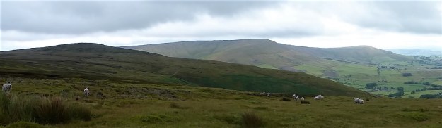
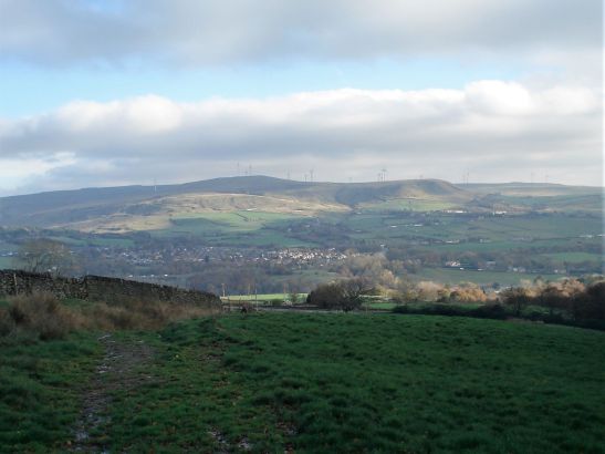
Then above Alcock’s Farm a long series of fields to Harterbeck Farm. A family are out for a pleasant Spring stroll, why didn’t I do the same? Lambing has been in full throw. The way was clear but the ground was boggy, which became rougher the farther I go, it would be just as enjoyable, probably more so, to walk up the quiet road leading to the farm without losing the views or the curlews calling. Next time. Great Coum, Gregareth, Whernside and Ingleborough were constant companions on the NE horizon.  Ingleborough always wears the crown and demands to be photographed.

P1050053

P1050060P1050058P1050064P1050071

P1050078

P1050061

Harterbeck is a lonely farm by any standards. It obviously has a problem with moles and the windows inserted into the back wall must have involved ‘Bob the Builder’.P1050082P1050081P1050084P1050083

P1050086

I’ve been exploring Lancashire for years but I have never been into the steep-sided Pedder Gill and seen the waterfalls of Goodber Beck. Must have spent too many times abroad in warmer climes and neglected my own doorstep. From the farm, after crossing a small beck, the track drops down to the little footbridge and a bit of scrambling down the gorge gets me in close with the waterfalls. A hidden Bowland gem!   P1050087 P1050088P1050095P1050094

P1050102

P1050097P1050099P1050100A stroll down the fields and I pass through Lower Salter farmyard. The farmer is repairing his drystone wall, must be the season, but he is not as chatty as the one in Lunesdale the other day. What an isolated life they live up here. P1050125P1050127P1050129

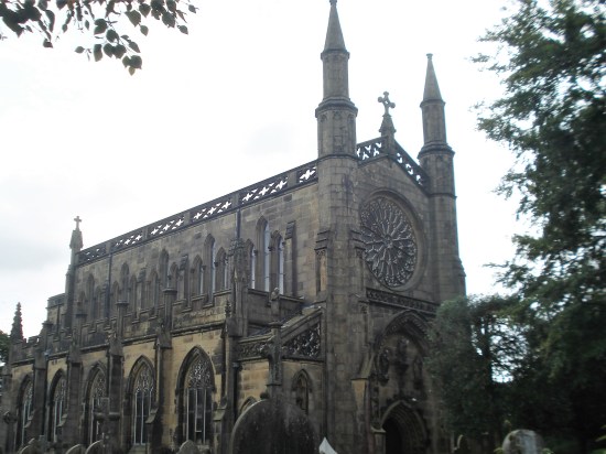
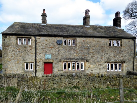
At the road is the little Methodist Chapel. I go inside for a sit-down and snack.

 Built in 1901, the land given by Mr Francis Skirrow of Lower Salter Farm, the cost of the chapel was £180. Mr Skirrow intended the chapel to be used as a school room during the week. This is evidenced by the fact 
that the pews have holes for inkwells. However, his 
idea never materialised owing to an inability to hire a teacher. There is a commemorative plaque to Flight Lieutenant Thomas Dirk Bayliss who lost his life on July 3 1979 when his Jet Provost trainer aircraft crashed into a field near High Salter Farm after the pilot became disorientated in heavy mist and flew off course.

P1050131

P1050132

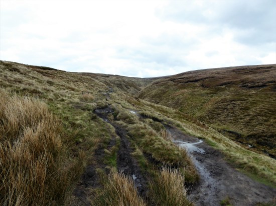
Down the road and with spirits high I cross the stile onto that permissive path down Roeburndale… A walk on the wild side.

THE WRONG ROUTE.

DSC00511

Following on from my last post which described a half aborted climbing session, today we now have a walk that didn’t quite work out. I’m on a losing streak. Again I’m with Mike reconnoitring for walks he could lead with his monthly walking group.

Remember the stipulations  “should start at a place with toilets, not too much rough ascent, between three and four miles, the fewer stiles the better and finishing at a pub for lunch”  He thought he had found one in a book of short walks in Lancashire, I didn’t catch the title. This time on the outskirts of Blackburn, Pleasington in fact, incorporating Wainwright’s Memorial on Billinge Hill and the popular Witton Country Park. Sounded promising when he invited me to join him.

Things didn’t go well when we struggled to park near the Railway Inn, yes there is a station here for commuting into Preston or Blackburn. We eventually settled on roadside parking up the lane which wouldn’t be ideal. Shame that the nearby Butler’s Arms is closed. We set off, walking up the lane past the impressive Pleasington Priory. Pleasington Priory – Wikipedia We don’t even think to have a look inside, if it is open. DSC00478

Up a smaller lane past expensive building conversions to the gates of the Old Hall. DSC00483

A track goes left here, and we soon come to our next problem, a loose eroded bank leading to an awkward stile. Probably no go for those of his group not into mountaineering. I didn’t think to take a photo of the obstacle.

A wandering route through rough fields brings us out onto a lane I recognise from previous Witton Weaver Walks which we now follow up to the Yellow Hills, named from the abundant gorse that blooms up here – but not in September it seems. There are always a few people up here because of Wainwright’s Memorial plaque, a toposcope with a rather poor impression of Alfred in the centre. We gaze in all directions, but distant views are hazy, nevertheless a wonderful lookout. This ascent would have been better in reverse with the vista in front of you. Niggly. DSC00490

I never feel at ease through the next open field which always has cows and occasionally a bull. Today they all seemed very docile, perhaps it’s just my fears.

DSC00492
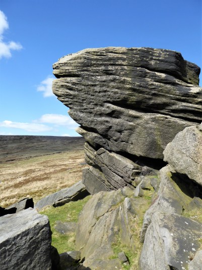
Entering the woods of Billinge Hill we pay particular attention to the guide’s directions. There are paths everywhere up here, some I recognise, but mainly I am ‘lost’ blundering about in a hopeful direction. Using a bit of creative thinking we follow the steep and slippery paths down alonside a ravine. Mike is not happy, any of his group who may have made it this far would be now struggling. DSC00485DSC00493DSC00494DSC00497

We in turn struggle down to enter Witton Park and civilisation. Ice cream vans, car parks, sports pitches, dog walkers. DSC00498

We are lucky to have this rural expanse open to all on the edge of a major town. Witton Country Park covers 480 acres of countryside with pretty picnic spots, walks, nature trails, play areas, sports pitches and a visitor centre. The estate was once owned by the Feildens, a wealthy textile family, who built and lived in Witton House from 1800 and created the park at the same time. From 1900 the house was empty for long periods and during both world wars the house and estate were used by the army. Dry-rot set in. Witton House was demolished in 1952, after being sold to Blackburn Corporation in 1946 along with the estate. DSC00504

We join the crowds and follow the sluggish River Darwen down the valley to Butler’s Bridge. Now on a surprisingly busy road ahead are the gates leading to Pleasington Cemetery.  I’ve never ventured farther, but the notice board shows a vast complex of burial grounds. DSC00502

We divert to continue into the woods and up a sunken lane which eventually is captured by barbed wire into a most unfriendly narrow walkway back to the priory. DSC00508DSC00509

We have had 4 miles of exercise through an interesting environment. It took us for some reason three hours and Mike has ruled it out from his future itineraries.

Last year I did a similar, but better balanced walk , from Cicerone’s Walks In Lancashire, an excellent selection, which also took in Hoghton Bottoms in a seven-mile circuit.

Back to the drawing board for Mike.

***

 Witton (2)

CICERONE’S LANCASHIRE – GRAGARETH’S MEN.

P1020312 (2)

Well there were JD and me, the three scientists doing a peat survey for some research organisation, the Three Stone Men who have been there for who knows how long, and a few others stone ones scattered around. The peat survey was interesting as we are just waking up to the importance of peat as an important carbon storage resort. We were happy to sit in the shelter of the Three Men as there was a distinctly cold breeze coming from the Northwest. A good opportunity to take a break and eat our sandwiches.

Our journey up the motorway had not been straight forward as I missed the turn-off to Caton and the Lune Valley. Another junction farther north and JD’s phone chose an alternative route over towards Kirkby Lonsdale, although eventually on the A65 we ignored the lady navigator and followed the sign up to the little hamlet of Ireby.  I shall not reveal where we parked, but there should be space by the telephone (book) box. Surely we are in Yorkshire by now, but no the Lancastrians have pushed a finger into Cumbria and Yorkshire.  We are in fact out to climb the highest (allegedly) hill in the Red Rose county, walk number 16 in Mark Sutcliffe’s Cicerone guidebook.

Up to now we have been walking on a distinct lane out of Ireby and then the tarmac road heading up the fell from Leck. All easy going, gaining height almost effortlessly, at least we could keep up a good conversation without getting out of puff. JD is super fit at the moment having recently completed a pilgrim route to Santiago, a Scottish trip and The Dales Way. I was hoping that his all-inclusive hotel stay in Menorca with his wife might have slowed him down. We are in limestone territory. P1020289P1020292P1020298

This road leads to a remote sheep farm. I used to park up along here for exploring the nearby Leck Fell potholes. Short Drop Cave was always a favourite, lowering yourself in with your feet dangling in fresh air in the darkness, dare you let go of the rock? Of course, you did and only dropped a few inches! You could explore the channel for some distance and then worry about getting out again. But today we were heading up to those stone men visible on the hillside above. Conversation dwindles on the steepest scrambling bit, look at the contours, and we are all too ready for that rest at the Three Men. P1020305

P1020310

The Three Men.

P1020321

The Three Ladies.

P1020315

Lunch over we chat to the peat surveyors before strolling the last section to the lonely trig point on Gragareth, 627 m, the highest in Lancashire. Now this is where some debate comes in, farther north across the barren moor is Green Hill, still in Lancashire, and marked on the OS map as 628 m. We don’t fancy the two-mile boggy trudge up there. But help is at hand – in 2014 the Database of British and Irish Hills suggested  “Gragareth replaces Green Hill as Lancashire county top”.  Gragareth having a height of 628 metres, 100 metres east of the trig point, while Green Hill is 627.5 metres. Who knows?  P1020324

Anyhow, we slink off along the wall southwards. But I have forgotten to tell you about the views from that highest point. Morecambe Bay, Lakeland hills, nearby Barbon fells, all those rounded hills up to Dentdale, Whernside and of course stately Ingleborough, distant Pendle and the Bowland Fells, quite a collection.

P1020323

Northwards.

P1020334

Whernside.

P1020329

Ingleborough.

On down along the wall and then a vague path down to the ‘Turbary Road’ above Kingsdale, a track used by peat cutters – yes we have been destroying the land long before climate change was thought of. This area is full of caves, potholes and dry riverbeds, but the way missed most of them out. On reflection a few small diversions to peer into these limestone features would have added interest. P1020331

P1020338

P1020339

Marble Steps Pot.

P1020345

Twistleton Scar End.

P1020344

Turbary Road.

Once on the lane we made good progress stopping only at a bench for a drink, out of the vegetation crept a giant dung beetle. P1020348

Masongill looked delightful.P1020349

Freshly cut green fields, and we were soon crossing the ancient clapper bridge into Ireby.

P1020350P1020353

It was good to be back in Limestone Country, as you can see the weather improved as the day went on. Eight and a half miles with 1700ft of ascent – I’m still thinking imperial.

***

CaptureGragareth (2)

CICERONE’S LANCASHIRE – ?FORBIDDEN BOWLAND.

P1020180
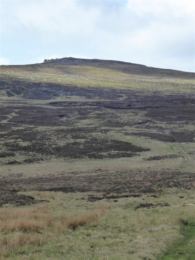
Sat alone on the isolated true summit of Fairsnape, deep in Bowland, I’m poking at one of my sandwiches, egg and tomato, made a month ago. They went into the freezer when hot weather and circumstances cancelled an outing at the last minute only for them to re-emerge this morning. there is a distinct unappetising taste.  Should you freeze hard-boiled eggs? I’ve just traversed some of the loneliest hills up here and am in need of some sustenance.  The morning has been misty on the fells, however with a welcome cooling breeze. Distant views are restricted from my lofty perch, most of you will never have been here. Only a few curlew and grouse share my space. I poke again at the sandwich and decide to toss it into the heather for probably the seagulls, who now also patrol these heights, to scavenge.

As I say the day started off murky and cool with low cloud, quite the opposite of the mini heat wave we have been enduring. Ideal for a tramp across these Bowland hills. For a start don’t take Mark’s advice to leave your car in the Delph Lane car park, it’s none too safe and leaves you with quite an uphill walk before you start. There are suitable lay-byes nearer Stang Yule. Walk number 2 in the Cicerone’s Walking in Lancashire  book.

The way starts at a gate leading onto open access land. Welcome. On closer examination a notice says ‘No open access – temporarily closed at the land manager’s discretion’ Not a  good start at all. But wait, the date is 2021. This sign has not been removed or updated for two years. So much for the land manager.

P1020163P1020274

I try not to read too much into this as I stride boldly onto the access land. Nobody will see me in the mist. I’m enjoying the heather under foot, there is a path of sorts but not many come this way, put off by that notice possibly. Slowly I gain height and pull away from the plantation onto the open fell side, A track takes me across the slopes of Hazelslack Fell, a rarely visited spot. The last time I was up here was with Sir Hugh and JD on our straight line adventure between our homes. It’s as remote as I remember. P1020165

P1020169

The views back to the Fylde are supposed to be good.

P1020183

Approaching Hazelhurst Fell.

P1020186

Looking back with the track skirting below the summit of Hazelhurst.

I don’t bother with the 429 m trig point this time as I’m probably going higher shortly. The track dips down and climbs the contours gradually onto Winny Bank. The raison d’être for this track becomes obvious with the appearance of shooting butts. Not only the butts but also the small mammal  traps, thankfully decommissioned. The highlight of my week, if not the month, was witnessing a family of Stoats crossing a road on Longridge Fell. Distinctive with their black tipped bushy tails. Who would want to trap and kill these beautiful animals?? P1020188P1020189P1020197

Along the way is a stark memorial to airmen lost on these hills in WWII, I have a book somewhere  listing all these crashes and giving their accurate sitings. P1020196

The track starts to descend, and I have to be alert to pick up the ongoing path to Fairsnape otherwise I would be floundering, I know not where. The path begins somewhat unlikely with a few steps leading off a turning place. The stone flags don’t go far and one is left following intermittent white posts through the morass of peat. You will be glad you came here in dry weather, preferably a draught, also not a good place to be in thick mist. Stick with it, and you will arrive at a fence corner euphemistically named  Webster’s Meadow. (if you miss it you would be in ‘Dickey’s Meadow’) This is also known as Fiensdale Head, the way through from Langden to Bleasdale. A partially flagged path shows the way. it’s a long time since I’ve been down Fiendsdale, a good spot to see ring ousels. No idea who Webster was or Dicky for that matter.

P1020199

Turning spot.

P1020200P1020201

P1020205

The way down to Fiendsdale.

United Utilities have an information board explaining the work being carried out to try and reverse some of the peat erosion. When I was last up here they were helicoptering bags of stones in to be incorporated into ‘dams’, stopping further erosion from run off and re-wet the surrounding peat. Evidence of that work is all around with stone and fibrous matting in the peat cloughs. One does wonder how much we can do to repair the damage which must be on a vast scale in Bowland alone. Are you still able to buy peat based compost – I hope not? P1020204

P1020214P1020216

A few more flags are encountered, showing a way down to Bleasdale and ahead to Fairsnape. Then you are on your own again with the fence for company. The book talks of ‘hard going’ in the peat hags – ‘hopping over to the other side of the fence may help’ Today that is not necessary as it is as dry as it is going to get, but there are still boggy morasses you wouldn’t want to fall into, perhaps the re-wetting is working. Knees are allowed for climbing out of the deepest hags. P1020213P1020208P1020221

Anyhow, I’m soon sat at the 520 m summit contemplating my lunch. There is another informative board up here telling the same story. Some of the funding came from the EU, pre Brexit. How much will our own DEFRA run by Thérèse  Coffey put into environmental schemes? P1020222

It’s a dry run over to the other summit of Fairsnape, the one with the shelters and trig point. I’ve not seen anybody all day so far and can’t believe I’m the sole person at this popular top. Only when I get closer to the shelter do two heads pop up – a young couple having some private time to themselves. P1020228

The mist has lifted a little allowing the gliders from the club down below to take to the thermals, spookily and silently sliding past out of the thin cloud. P1020226

The way off, by a cairn, is down some zigzags into Bleasdale. I have always assumed these to be part of a sledging route for bringing cut peat off the fell. Beautifully constructed and a joy to walk whichever direction, up or down. Few people used them as most are linking Fairsnape with Parlick along the ridge. But Mark knows this area well, covering Bowland in detail, the secret is out. P1020230P1020232P1020241

P1020243

P1020259P1020273

What a contrast from the northern side of the fells – endless peat and heather as far as the eye can see and down here in Bleasdale with the green pastures stretching to Beacon Fell. The guide book takes you on tracks that would give access to Bleasdale Circle, but I’ve been there many times and at the moment it is a bit of a mess following storm damage to the trees, so I take a slightly different route through Bleasdale, past remote farms, past the old reformatory school buildings and past Bleasdale Tower. North Lancashire Reformatory for Boys, Bleasdale, near Garstang, Lancashire (childrenshomes.org.uk)

P1020278

That little lay-by.

The little blue car was waiting for me in that lay by, as a Duke Of Edinburgh group were going through, staggering in the heat under massive rucksacks. I wonder who had the better day?

***Capture Hazelhurst (2)

CICERONE’S LANCASHIRE – MORE OF THOSE LONG LONELY BOWLAND MILES.

P1010746

                                                                      Catlow Fell and Bowland Knotts.


Mark Sutcliffe’s Chapter 4.  Bowland Knotts and Cross of Greet.

Driving the lanes to Slaidburn once more and this time taking the continuation towards the Tatham Fells to park at the Cross of Greet Bridge, deep in Bowland. The last time I started a walk from here along the River Hodder, November 2020, the whole area was waterlogged and virtually impassable.  I am hoping for better conditions today after a few dry days. It’s a Bank Holiday weekend, yet I’m the only car parked up by the river.P1010901

I skip across the marshy area and have no problem fording the stream this time. The walk-up to the isolated barn goes well. A barn owl is disturbed as I peep inside, it flies off, and the chicks go quiet. I don’t hang about. Outside was a rusting lime spreader manufactured locally in Clitheroe ? Vintage 1960.

P1010751

The infant Hodder.


P1010759

Kearsden Brook ford.


P1010760

The Hodder gathering pace.


P1010764

The barn.


P1010770

Abode of owls.


P1010772

Atkinson Spreader, Clitheroe.

The way onto Pike Side is rather vague, and I end up following sheep tracks and even sheep. I realise that somewhere I have gone wrong arriving at an old lime kiln next to the wall, SD 725591. There are shake holes marked on the map, so there must be underlying limestone near about. With a bit of rough ground I regain the route by the gate, SD 723593. There are the ruins of an old barn here, and I follow the straight access track all the way to the road at Bowland Knotts, although at times it disappears underwater.

P1010777

Sheep track.


P1010788

Limekiln  SD 725591. 


P1010792

Gateway. SD 723593.


P1010808

To the road at Bowland Knotts.

There are craggy outcrops either side of the road and some are suitable for bouldering.  I find a seat not far off the road for lunch with Ingleborough in full view.

P1010816

Roadside bouldering in Yorkshire.


P1010817

Roadside bouldering in Lancashire.


P1010818

Peggy and John Phillips seat.

Tracks follow the wall westwards towards a trig point, 430 m,the highest point of the Bowland Knotts also recorded as Crutchenber Fell, a ladder stile crosses to it. This is a rough tramp, but there are good, if hazy, vistas into Yorkshire, Stocks Reservoir, Pendle and the Bowland Hills.

P1010821

Crossing to Crutchenber Fell.


P1010824

Trig 430 m.


P1010823

Bowland Knotts.

I stay on the south side of the wall for the undulating mile to the next feature, Cold Stone Crag. There is a path of sorts. There is climbing on this remote crag, but I doubt if many come this far, you might as well boulder back at the road. On one occasion I made the boggy walk in to photograph the crag for a new guidebook, only to arrive after the sun had moved round. The process was repeated the next day at an earlier hour. From up here the whole of the Pendleside panorama is visible.

P1010829

P1010831

P1010834

P1010837

Forever onwards alongside the wall and a gentle climb up to a height of  486 m, no cairn denotes the ‘summit’. The miles are long up here. An undecipherable boundary stone is encountered. The maps vary on the name of the hill – Great Harlow, Hailshowers Fell, Raven Castle or perhaps Catlow Fell.

P1010838

Catlow or Hailshowers Fell.


P1010845

Boundary Stone – Lancs/Yorks.


P1010847

Ravens Castle stones?

A little farther and a fence line leads me down to the road at the Cross of Greet. By the cattle grid is a large stone with a shallow square hole in the top. It stands at the Lune/Ribble watershed. formally the Lancs/Yorks border and may have had in the past a stone cross inserted into it.  Or was it a plague stone? nobody knows. I think it’s more likely to have been a cross at an important passage through these remote hills. 

P1010854

I chat to some cyclists riding the classic round from Slaidburn. Up to the Cross of Greet, over Tatham Fell past the Great Stone, maybe a brew at Bentham or Clapham and then back over Bowland Knotts, through Gisburn Forest to Slaidburn. I did it once with my mate Tone, never to be forgotten. P1010858

Down the road for 800 m then follow one of the faint paths down to the stream”  Well I’m not sure about the 800 m, and I don’t find any obvious paths. It will be even worse once the all encompassing bracken has grown. But I do find myself down at the Hodder, not the magnificent river it will later become, and hop over to the other side. P1010863P1010864

A slight climb and I am on the brink of an abandoned quarry. Stone from here was transported by rail to build the dam of Stocks Reservoir as the valley was slowly flooded in the 1930s for the Fylde Waterboard. Only the church was saved, stone by stone and rebuilt on higher ground. There is lots of archive material online.  The quarry is atmospheric particularly with the surviving, but rusting dinosaur of a steam crane. P1010868

P1010871

P1010877

P1010875

P1010884

At the edge of the quarry is the base of the Far Costy Clough, a worthwhile scramble up onto White Fell I’m lead to believe. Yet another one to add to my list. Another day.P1010880

I’m content to just to follow the old rails  out of the quarry back to the  Cross of Greet Bridge. Another longish day out in Bowland.P1010885

P1010891


P1010897

P1010900


***

CaptureCross of Great (3)

CICERONE’S LANCASHIRE – REMOTE BOWLAND.

P1010516 (2)

I’m running out of titles for my series of walks in Bowland as set out by Mark Sutcliffe in his Walking In Lancashire book. He has certainly covered the area well. Highest, Best of, Heart of,  and today Remote or even the Remotest…  How many of you have been to Wolfhole Crag  or Whitendale Hanging Crags? This is a long post I’m afraid – it was a long day.

I enjoy the familiar drive into the hills with the roof down. Along the Hodder Valley; farmers busy silage cutting in the fields; over the Roman road with views to Ingleborough; down to picturesque Newton; along to stately Slaidburn and up Woodhouse Lane to my parking place just before the fell gate. I say my parking place as it was a regular spot when we were developing the bouldering potential of Croasdale’s Bullstones all those years ago. Not many drive up this far, but Mark mentions the single space, there is a little more back down the lane.

P1010468

Newton on the Hodder.

The hike up the rough Hornby Road, a Roman Road again, (aka Salter Fell Track) has been done dozens of times and I pass familiar landmarks. The war memorial to airmen lost on these fells; the ancient sheep folds and bothy down in Croasdale where I have stayed with my grandson; the culvert where one can still see the Roman workmanship; the large quarry where the peregrines nest; the bridge where the road has been saved from sliding into the valley; the Tercet stone demarking the Lancashire Witches fateful route to the assizes in Lancaster;  over to the right the bouldering playground of Bullstones and later the vague track dropping into upper wild Whitendale. P1010473

P1010484

P1010485

P1010492

P1010489

P1010494

P1010507

P1010527

Along here somewhere I meet two RSPB workers checking on nesting Hen Harriers. It is good the birds have returned and let’s hope more survive the persecution by the shooting fraternity this year. No photos and as they say on the news “their anonymity and location have been protected”  The road goes on over the watershed.P1010503

After four miles I leave the road for another four miles of mostly trackless and waterlogged ground. Mark says “the next stretch is very boggy and needs careful negotiation” Go no farther if you are unsure or if the weather is bad. This is remote country with no easy escape routes. My walking poles disappear into the mire quickly followed by my boots. Jack be nimble. It is not so bad – I survived. There is beauty there if you look closely.P1010534P1010536P1010541P1010540

P1010539P1010535
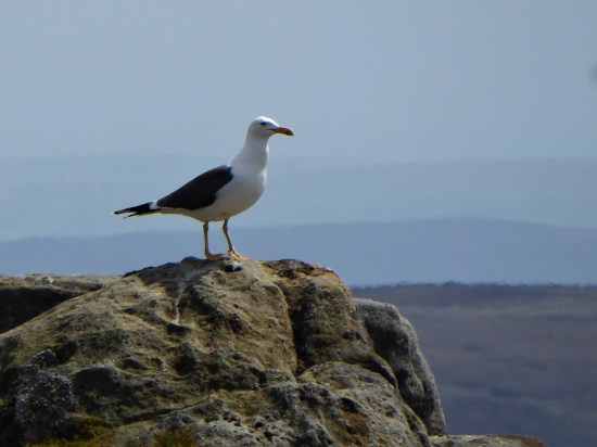
If I close my eyes I could be at the seaside, the sound of gulls is everywhere. I think they are Black Backed, Great or Lesser?, a large colony exists up here. I try for a video, more for the sounds than the fleeting fly overs. They are becoming more aggressive, dive-bombing me. I look down and there below my feet is a scrape of a nest with three eggs. Better move on taking extra care where I place my feet. 

P1010599

P1010555P1010590

It doesn’t take much to persuade me to take the ‘optional’ diversion to Wolfhole Crag half a mile away. One wouldn’t come this far in good weather and not go to the highest point. There is a trig point, 527 m, and also an interesting collection of gritstone boulders. I can’t resist a few simple boulder problems, keep them simple as you don’t want to break an ankle up here. The longer routes look fearsome. Somewhere there is a shallow cave in the rocks – the original wolf hole. P1010552P1010559

P1010567P1010569P1010577

A good place to eat my sandwich, wish that had been two as the day panned out. All around – The Lakes, Yorkshire Three Peaks and most of East Lancashire. Pendle is always visible. All a little hazy in today’s heat. P1010578

Walking back down the fence line, no navigation needed, is not easy because of more bogs. Maybe it is better on the other side, No it isn’t I tried. White Crag is nothing but a few boulders. Whitendale Hanging Stones are not much bigger. But according to the gravitational method to establish Britain’s centre of gravity  OS calculated that the geographical centre of the British Isles, including Islands, lies at SD 6419 5654 virtually where I’m stood. I’m too weary to take it in. In fact as I drop down very steeply I’m just too pleased to see the small tarn on the col between Brennand and Whitendale. The walls and fences aren’t too easy to negotiate. I lose even more height as I descend to the Duchy farm at Whitendale where my route ahead climbs back up zigzags for 800ft onto Dunsop Fell. P1010614P1010609

P1010611

White Stones.


P1010619

Whitendale Hanging Stones, centre of Britain.


P1010632 (2)

My way down.

P1010643P1010646

Small mammal traps remind me I’m on shooting lands, the hunting class have some barbaric practices. P1010637P1010636

I collapse onto a wall at the farm, nobody is about, I’m even wondering if I should phone my son for a cop-out evacuation, but a drink and a banana fortify me for the final stage. Thankfully once back on a stony trail my steps become stronger, and I push on up.  The trail disappears into peat, but there are some posts and cairns to guide me to Dunsop Head, a vague col with a wall, gate and another of those crafted signs. Looking at the map and the terrain I realise I’ve never been on Baston Fell to the north, today is not the time to visit. Let’s just get down.  

P1010642 (2)

My way back up.

P1010648

P1010649

Looking back down to Whitendale with Hanging Stones above somewhere.

P1010654P1010655

P1010659

Go east across more bog. By the time Stocks Reservoir comes into view you are almost home and dry, although your feet are probably wet by now. Eventually the bridleway becomes more visible as a sunken way and the airmen’s memorial appears. There is my car down the lane with Pendle still watching over us. Seven hours of remote walking, one to talk about in the pub later.  

P1010664

P1010667

P1010668

***

CaptureWolfhole. (2)

CICERONE’S LANCASHIRE – East is east.

P1010066

Walk 37. Weets Hill from Barnoldswick.

Barlick, until local government reorganisation in 1974, was in the West Riding of Yorkshire. It then found itself in Lancashire, the locals were not happy and many still see themselves as Yorkshire folk. Back in the day, until 1992, you had to be born in Yorkshire to play cricket for the county and I seem to remember special dispensations being given to players from Gisburn/Barnoldswick area when they were in Lancashire. Or was that just a rumour at the time. I do remember well however White Rose flags flying defiantly in Gisburn as you drove through.

None of this has any relevance to today’s walk except to point out we are in the far east of the county where Lancashire mills give way to Yorkshire dales. A 10-mile day of easy navigation, gentle gradients, canal towpaths, a Trig point and lots of fields. Stick with it – there is plenty of interest.

I approached the recommended Greenber Field car park down the narrowest of lanes, I was almost giving up when it suddenly appeared hidden in the trees. On my return I took a wider road, the B6252, back into Barnoldswick and I would recommend that as your approach. Unfortunately the café on site was closed due to staffing shortages, a common problem of hospitality in these strange times. That’s the second day in a row I have been deprived of my coffee. Still the day was promising with warm sunshine and blue skies.

I set off with enthusiasm along the canal towpath on the edge of town. Easy strolling with lots of friendly and well-behaved dog walkers, pram pushers and cyclists. I passed three of the prominent manufacturers in town – Rolls-Royce, Silent Night beds and  Esse stoves. All but one of the many cotton mills have gone. The canal was busy with boaters. On my longer canal walks I often try to pick out the most humorous, or more likely corniest, boat name of the day, Mr. Grumpy won today. All making for an enjoyable start to my day’s walk.P1000990P1000987P1000991P1000997

In fact the morning was disappearing fast – made more so by an extended chat with an enthusiastic walker. We got onto the subject of the Lake District which he seems to have just discovered. Out came his phone with pictures of Coniston, Helvellyn and Scafell etc, many in selfie mode. I had to make my excuses to get under way again. 

Once I had left the canal I saw virtually no one else for the rest of the day. 

My way up onto White Moor was mainly on well surfaced bridleways, that PBW again. As height was gained the views opened up, with my recent ascents of Bouldsworth and Black Hambleton prominent to the south along with the rest of the Pennine Chain, and there was little Blacko Tower. Perhaps I was distracted, but I took to the moors sooner than I should have, up a well trodden track (SD 869 441). On past a plantation obvious on the map, that’s when I realised my mistake, but the track alongside a wall was good, so I just kept going until I was within a stone’s throw of the summit. Birds eye views of Barnoldswick appeared way down below.

P1010026

What did I say about easy navigation?  As it happened this was possibly better than the longer way round and up the tarmacked lane to Weets House, it was easy to navigate once I knew I was lost – if you follow my logic. 

The summit was adorned with a shiny white Trig Pillar and even better as I was ready for lunch a memorial bench. And what a panorama – the nearby bulk of Pendle, Longridge Fell, the Bowland Hills , Ingleborough and Pen-Y-Ghent and lots more. The Ribble Valley stretching out in front of the hills completed the scene. P1010028P1010029P1010036

It was only after some time sat there enjoying the view that I noticed beneath my feet little plaques set into the soil, each one a memorial to a departed family member whose ashes were no doubt scattered up here. I like the idea of being scattered from one’s favourite hill, but I thought the plaques possibly out of place. No offence to any family concerned who had the wishes of their departed granted.

Time to head down, and I followed the track I should have come up to Weets House, an isolated property as you could wish for. Back on the PBW I headed north wondering who had travelled this way in the past centuries attending to their trades. Miners, pack horses, farmers, soldiers?  The map depicts ‘ancient earth works’ from early times and there is a Roman Road crossing my track at one point. P1010042P1010049P1010048

A quiet road, Brogden Lane, winds down the hillside past upland sheep farms and comes to a right angle corner at The C18th Manor House, what you see from the lane is actually the back of the house. A ford then leads to Brogden Hall.  That was my way and I circled around what is a large equestrian centre with only a glimpse of the hall itself. Out into the fields I crossed a motor cross circuit – the penny dropped I have been here before. It was when I was walking the West Craven Way in 2015. P1010054P1010053P1010055

The pastures were full of deep grass which surprisingly makes walking through it tiresome. It’s that time of the year when the dairy herds are let out for some proper food. Passed a reservoir, and I was into a field with one of the largest herds of cattle I’ve encountered. They can be frisky at this time of year and being cautious I took to a path on the other side of the wall. After my minor trespass I was back on route up a slope now with grazing sheep and their lambs. I couldn’t resist a spring lamb photo, or two. Can’t you just taste that luscious grass? P1010059P1010063P1010068P1010069

I worked my way through the gardens of some nouveau riche house, their garden furniture was more stylish than my lounge. I’m not jealous, but it set me wondering if they were entertaining would you be offered a drink en passant. P1010071P1010072

This was on the edge of the little hamlet of Bracewell where there had been a former hall. The church, St Michael’s, dates back to the C12th but most of the present fabric dates from the C16th, though there is a Norman style arched doorway and apparently inside a Norman font. (it was locked today) For some reason I ignored adjacent Hopwood House and Farm, both grade II listed. But my attention was drawn to the ‘Old Post Office’ with its inscribed plaque, but why on earth did someone build a porch whose tiles obscure that plaque. P1010075P1010077

P1010080

P1010081

I have a gripe with Mark for the next part of his route down the busy and twisty B6251 road. This is dangerous considering the speed of traffic along it. Driving back along that stretch on my return I was behind an articulated lorry doing well over the permitted 40mph, no chance of that stopping quickly. Looking at the map there is a footpath leaving Bracewell to the abandoned village of Stock where there may be earthworks to see. A public footpath from there crossing Stock Beck would bring one back onto the  bridleway route. I wish I had taken that way, which as well as avoiding the dangerous road looks to be of interest in itself. I would recommend you do.

I didn’t, and I had to brave the oncoming traffic for half a mile until I could escape onto a peaceful bridleway. If you look closely at the contours of the countryside here you will see lots of small hillocks. These are drumlins, glacial deposits of boulder clay on the surface limestone. Today with the abundant Spring greenery they took on a magical landscape over which I expected troops of elves to come skipping along. It was however a good place to watch lapwings in their rapid flight.  P1010088 (2)

P1010093

The walk ended through Greenber Field Farm. All very neat and tidy but far removed from the farming as I knew it. Massive sheds, computerised cows and not a farmer in sight’. The C18th house itself is Grade II listed.P1010101P1010104P1010105

Well not quite the end as I spent some time watching canal barges come through the lock gates, the summit of the Leeds -Liverpool Canal.  P1010106P1010109

P1000982

***

CaptureBarnoldswick.

CICERONE’S LANCASHIRE (and a bit of Yorkshire) – On the hoof.

P1000795

                                                                               Black Hambledon.

Another skylark day.

I hadn’t decided where to walk this morning but after a bit of faffing I hurriedly opted for a ready-made route, no 39, in Cicerones’s 40 Lancashire walks book by Mark Sutcliffe. It is described as the Reservoirs of Worsthorne Moor, but it is far more; traversing post-industrial landscapes, wild gritstone boulders, trackless moor, endless views and the summit of Black Hambledon, Hoof Stones Height, 479 m. I haven’t knowingly been up Black Hambleton before and today’s route virtually circled it before committing to the top.

It was almost lunchtime when I parked up on The Long Causeway, an ancient route from Pendle through to the Calder Valley, now dominated by wind turbines.  A fell runner was just returning from his morning circuit, there was still a chill in the air. (we’d had a ground frost)

Some of the early tracks I remembered from The Burnley Way done back in 2017. Leaving the wind turbines the way drops down Shedden Clough into an old limestone mining area where they used ‘hushes’, dammed watercourses to uncover the limestone. There was evidence of industrial activity wherever you looked. P1000808

P1000817P1000816

A man from Salford was exercising his two dogs down by the bridge. He escapes up here for fresh air and tranquillity. The young dogs were having a great time, I think they were pleased to be out of Salford too. A couple of mountain bikers came through and after that I met no one until almost finished. P1000811P1000814

I was on the Pennine Bridleway heading towards Cant Clough Reservoir set deep in the hills. Normally one can go across the dam, but there was maintenance work in progress which meant a  tiresome diversion down the valley and back up again. They were ‘repuddling’ the clay lining, probably the first time since the construction at the end of the C19th. You may remember the 2019 panic when the reservoir dam above Whaley Bridge was put under strain and threatened the area with flooding. P1000829

P1000827

In another extensive quarried area I soon left the PBW, for a while anyway, and headed on a smaller path bordering the wild Rams Clough up into the hills towards an unnamed 468 m summit. All was quiet except for the joyous skylarks. I was soon looking back at Cant Clough Reservoir. The path became steeper and rougher – a sign of things to come?

P1000839

P1000840

P1000847

I reached a bridge in the middle of nowhere carrying the BBW where I managed a photo of a Wheatear which flew from post to post, I remember several of them in this very same place on my Burnley Way outing. P1000848

P1000800

Passing into Yorkshire, Gorple Upper Reservoir now came into sight below and there above me the Gorple Stones, which looked as though there would be bouldering possibilities. But how often do you get a day like this up there? P1000855P1000856

Ahead now was the prominent Gorple Buttress. I recall the excitement in the climbing magazines back in 1995 – “John Dunne has climbed an E7 on the jutting prow of Gorple” Walking below it today it looked as impossible as ever, overhanging and slopy, I wondered if anybody has repeated it. Dunne went on to produce an even harder more direct line at E9 three years later. A good spot for lunch gazing down at the remote reservoir and across to Black Hambleton. P1000860

P1000859

P1000869

P1000956

John Dunne on Eternal E7, cooler day.         David Simmonite.

Stirring myself I was soon down to the dam. Mark’s route goes a little down the valley, towards the lower reservoir, before climbing again, but I spotted a level path getting to the same point by crossing, possibly illegally, the dam  and using the estate’s shooters’ track. Not advised in the killing season. There were some very attractive little gritstone buttresses above that valley, I may need to return. P1000873

P1000893P1000887P1000909

P1000898

 Gorple Lower Reservoir.

Across the way were the hauntingly fascinating ruins of  C16-17th Raistrick Greave, presumably abandoned when the reservoirs were constructed, around 1930. It had been a large farm and buildings, one suggestion is that it may have been also a stop-over on the local packhorse trails. Reaps Cross is nearby and of course The Packhorse Inn over at Widdop. P1000907P1000915

To be honest I never really picked up the path again. The ground is very rough and tussocky, when I thought I was back on track I usually ended up on a sheep trod going nowhere. I just battled up the hillside keeping to a southerly direction avoiding Clegg Clough for more than one reason. All around was that dry straw-coloured moorland grass so attractive from afar in the winter months. P1000922

Boggy paths started to appear on Hoar Side Moor and I followed one until I hit the fence which I could follow westwards up Black Hambleton at last.  All very bleak and isolated. P1000930P1000933P1000929

The trig point eventually appeared. I found a rock to sit on straddling the Lancashire /Yorkshire boundary. All around were the familiar Pennine Hills. Bowland, Pendle, Ingleborough, Boulsworth, StoodleyPike and many unnamed ones to the south.Way down below I could see a Barn Owl quartering the rough pastures.P1000934

P1000936

Pendle in the distance.

P1000940

Bench marked rocky seat.

I wish the walk could have ended up here as I never found the proper path off to the southwest, the rough ground making it hard going, and the mile alonside the busy road was scattered with litter.  But ignoring that last hour this had been a stunning walk of variety and remoteness, sorry I was distracted by all those boulders. I was tired by the end.  P1000954

***

  CaptureBlack Hambledon.

CICERONE’S LANCASHIRE – BOWLAND’S HIGHEST.

P1000644

It was alarming that my car radio suddenly switched from Radio Lancashire to BBC Cymru as I turned off the A6 towards Dolphinhome in deepest Lancashire. Had I taken the wrong turning somewhere down the road? it turns out their frequencies are very similar, still a bit strange.  I was on route to the heart of Bowland not Bangor. Tarnbrook’s few houses lie at the end of the road alongside the northern branch of the River Wyre. They are part of the Duke of Westmorland’s vast Abbeystead estate. I’ve covered this area many times before, most recently here in my Cicerone series. Parking along this narrow lane has always been an issue and the estate are discouraging us going past a suitable lay-by at the entry to the valley. I go along with this even though I know of a large grassy verge higher up the lane. These parkings are both  mentioned in Mark Sutcliffe’s walk number 10 onto Ward’s Stone in the Cicerone Lancashire Walks guide book, my objective for today. It looked far off on the horizon.P1000794

What a day, clear blue skies and sunshine. Rare enough in these northern hills. But there is a cool easterly wind blowing even down here as I start my walk along the lane to Tarnbrook. I add a few extra warm garments to my rucksack. The quiet lane runs alongside the Tarnbrook Branch of the River Wyre and its joyful passage keeps my attention on the mile or so morning walk up the valley, and of course the lambs. I pass Ouzel Bridge leading to  a farm. The Ring Ouzel, or mountain Blackbird, is found in the tree lined cloughs in the Forest of Bowland. Will I see any today, I have previously? P1000646P1000647P1000791P1000650

Once into the hamlet I take the concessionary path straight up the fell into open access land, roughly following Tarnsyke Clough. Unfortunately not a Ring Ouzel in sight but there are plenty of lapwings and curlews flying around. This is essentially a Land Rover track to take shooters up to the butts on the fell. In the past, before the CRoW act, it was jealously guarded by the keeper living in the hamlet. Us climbers wanting to go up to the forbidden Thorn Crag, seen up on the right, often resorted to devious tactics, walking up a longer, but permitted, way to the plateau and then dropping down to the crag. We came unstuck one day when my climbing partner uncoiled his new rope, a fluorescent yellow. We could be seen from Blackpool never mind from the keeper’s cottage in Tarnbrook. Session over we would walk boldly down the estate track knowing we would be rudely accosted but also knowing they would have to let us out at the hamlet, stalemate. Things changed with the implication of the access agreement, the same gamekeeper who had sworn at us the last year now wished us a good day. The worm turns. There are no confrontations today and I just plod on upwards at my steady pace. I can’t believe I used to carry a bouldering pad up here. P1000653

P1000667

Thorn Crag and boulders.

P1000664

Looking back down to Tarnbrook with Hawthornthwaite Fell behind.

I reach the ‘Luncheon Hut’, park your Range Rover here sir. P1000665

Onwards, I ignore the track off to the right and continue on to a division of tracks not specifically stated in the guide. It mentions contouring to the left, I somehow ignore this and  follow the tempting main track upwards to its terminus, SD593578, and then pick up a fainter path linking a series of shooting butts rising up the fell. All very pleasant although the modern butts resemble WW1 fortifications. I am obviously wrong but take a compass bearing on the trig point and climb onwards. With relief the conspicuous weather station up here comes into view, I was then only a few  hundred metres from the summit. It would all be far more difficult in mist. Probably would have been better to stick more closely to Mark’s directions.

P1000677

End of the road.

P1000678

Old pony track.

P1000680

Grouse bunker.

P1000687

The Fylde plain and Morecambe Bay lie down below, all a little hazy, as I reach the trig point, 560 m. The Lakes and northern Pennines were imaginary. By now the wind was almost gale force making any movement awkward. Fortunately there is a gritstone boulder, the Ward’s Stone itself, nearby behind which I cowered and added more layers of clothing. I used my spare balaclava to keep my cap from blowing away. Even with two pairs of gloves my hands were frozen. I was the only person out on the fell which was probably good considering my appearance.

P1000690

560 m trig with nearby Ward’s Stone.

P1000688

Grit Fell to the west and Morecambe Bay.

P1000691

Over to Caton wind farm with the Lakes hiding behind.

P1000696

Ready for battle at Ward’s Stone.

Half a mile across the sea of peat was another trig point one metre higher, so at 561 m the highest in Bowland. Why there are two so close together I can find no reason. All is Bowland emptiness to the east, except for Ingleborough’s distinctive summit across the  Craven Fault. The book says head for Ingleborough, but I found a vague path going to its right and meeting up with a fence line that comes from nowhere. It’s all too easy in clear weather like today.

P1000699

Heading just right of Ingleborough.

P1000705P1000704

P1000709

P1000711

Queen’s Chair.

The going was good to firm on what after rain can be a quagmire of peat. The fence gave way to a wall, which gave me a bit of shelter from the wind. Another fence lead me down the fell. The Three Peaks remained unclear but ahead the remote Wolfstones and White Hill were obvious. These latter two are rarely visited trig points in deepest Bowland. Having said that not a lot of people come this way, the path along Ward’s Stone ridge is not heavily used.

P1000716

The wall with Distant Pendle. I was having difficulty holding the camera steady.

P1000735

White Hill.

This part of the fell was being used as a seagull roost, and I  was dive bombed a couple of times. Judging from the number of gulls this won’t bide well for vulnerable eggs and chicks of Lapwings or Curlews. P1000736

Suddenly I was onto one of his lordship’s roads coming over the hill from the north. This took me all the way down alongside the upper Tarnbrook Wyre in Gables Clough to the valley bottom. Farmers were busy with their sheep and lambs. P1000759

P1000752P1000764P1000770

P1000776

In the hamlet the estate houses were being done up for a new lease of life. I remember a few years ago talking to a lovely old gentleman outside his house. He had lived there all his life and was the last resident still there. it will be interesting to see how gentrified the place becomes with new residents moving in. P1000783

SAM_4998

July 2014.

It seemed a long trudge back along the lane to my car. The extra road walking brings the mileage up to 10, more than the 7 1/4  stated in the guide. With hindsight, given the strength of the wind, it would have been an easier day in reverse.

***

This is what you may find on shooting estates. A snare cage trap on a log which is meant to kill predators such as the stoat or weasel. The problem is that other small mammals can easily enter and if the dimensions of the entrance are not correct so can larger animals. All very nasty to my mind. You wouldn’t want to put your hand in one! They make a resounding loud snap if touched with a ski pole.

P1000785

***

CaptureBowland

                                                                   BOWLAND.

Capture Wards Stone.

CICERONE’S LANCASHIRE – A LONG DAY ON PENDLE.

P1000383

I’ve been impressed so far with the walks from Mark Sutcliffe’s Cicerone guide to Walking in Lancashire. It’s a big county covering all types of terrain from the Coast to the Pennines, and he has chosen well. I must have walked most of his routes many times in the past, but he keeps throwing up little gems of variations new to me. Today was no exception. Nobody in their right mind would climb Pendle up those steps from the overrun village of Barley, I did in October 2020  as the lockdown restrictions for Covid were being relaxed. Never seen so much congestion on the roads or hill, but I was on a mission that day to find Fox’s Well. Mark takes us the quiet but long way up from the little village of Pendleton, a hamlet (tun) close to Pendle.

Pendle Hill dominates the landscape as you drive along the busy A69 though the Ribble Valley. It was along here I came today before branching off into the peace and quiet of Pendleton. I paid my dues and parked in the village hall’s car park as suggested in the guide, Walk 34 – ‘a challenging walk‘. I have been slowly increasing the mileage that my knee injury will cope with, it is nearly a year since the cycling accident that tore the medial ligament. Time is a slow but reliable healer, today’s rough 10 miles would be a test.

The sun is out as I walk past the Swan with Two Necks, I have visions of a pint outside on the return. Pendleton is unusual in that it has a stream running down its main street making it a favourite Ribble Valley venue. The pub regularly wins awards for its beer and food. Higher up the village the Fiddle Stone, once a clapper bridge across the stream now curiously spanning a patch of grassP1000368

P1000371

P1000500

P1000501

Leaving aside thoughts of beer, I soon take a lane into fields which rise up to Wymondhouses, a Pennine farm once used as a chapel. The plaque above the door states that the first Congregational Church in north-east Lancashire was founded here in 1667, a Mr Thomas Jolly being the nonconformist preacher. P1000382 P1000389P1000393P1000392

Rougher pastures and a sunken way led me onwards higher to come out onto the road at the Nick of Pendle, a low pass through these hills between the Ribble Valley and Sabden. A popular stopping off point for motorists seeking a picnic and a view. There were quite a few cars parked up this morning, the first people I had come across.

P1000395

Back to Longridge Fell and Bowland.

P1000396

P1000399

P1000401

Sabden down in the valley.

I was quickly back to peace and quiet on an obvious bridleway heading for Churn Clough and the Deerstones.

P1000403

Bridleway with Deerstones on the horizon.

P1000407

Below is the almost circular Churn Clough Reservoir, now used for fishing. Our path crosses the clough and then climbs steeply up its right bank heading for the Deerstones marked on the OS map. It is quite a pull-up. The day has changed, the sun has disappeared, and dark clouds fill the sky. The Deerstones look menacing in this light. At the back of my mind there is something of interest in the quarried stones, but I don’t divert without good reason. (I later read of the Devil’s Footprint. This feature was natural and caused by nodules of iron rich stone eroding out the harder gritstone bedrock. The legend is that the footprint was left by the Devil as he gathered stones in his apron to hurl at a nearby church. He then clumsily dropped them at nearby Apronfull Hill. I suspect that without prior knowledge the footprint would have been difficult to find. P1000419P1000412

P1000418

The Deerstones.

The path comes out onto the open moor at a gate. Paths go in all directions. I just head north on the vaguest of paths to join the main route coming up from the Nick. Pendle is a big hill and I feel minute in this landscape, it wouldn’t take much to get lost in its vastness on these SW slopes. All is sky and skylarks. You can’t capture this with a photograph, especially now that it is so dull.

P1000428

Could be anywhere.

The path becomes more defined on the lip of the prominent Ogden Clough, a highlight of the day so far. P1000429P1000431P1000430P1000433

I have distant memories of ploughing directly up that clough in a hard winter when all other tracks were obliterated. Today the going is good and as one approaches the summit the path has been ‘flagged’ to prevent erosion. There are still very few people using this way, but I fall into conversation with Max and his dog. He is full of tales of Lakeland walking, recently having completed the 214 Wainwright’s. He admits to being a little nervous on some of the Lakeland scrambles, I encourage him to take on Sharp Edge on Blencathra and maybe even Jack’s Rake on Pavey, I am not sure if he is convinced.

P1000435

Wes, dog and flags. 

By now we have reached the summit Trig point, at 557 m,and realise the place is thronged with people from the Barley side, what a contrast to our way up. Nonetheless, it is a good viewpoint over Pendleside and a sit down for a snack, but not for long as under the cloud it is decidedly chilly. 

P1000437P1000436P1000438P1000440P1000442A new path has been fashioned from the top of the Barley steps to the trig point. I must admit it blends as well as possible into the plateau and must save a lot of erosion. There is also a new stone shelter built into the nearby wall. Once through the wall as if by magic everybody disappears, and I have the whole of Pendle Moor to myself. There is no wind today, so it is almost perfect silence apart from all those soaring skylarks.

P1000444

Empty spaces – skylark country.

Past the stone shelter and on to Scout’s Cairn, the path is very boggy all the way. The Yorkshire Peaks are a bit hazy, but I’m focused on Kemple End, Longridge Fell and Parlick, Fairsnape Fell framing Beacon Fell straight ahead. As I said photography is difficult in this light. P1000448

The moor goes on forever. But is that sunshine returning? And now for that little bit extra. After a memorial cairn I drop steeply down into the extensive Ashendean Clough, a deep incision in Pendle’s SW slopes. This could be Scotland.

P1000460

Memorial to two Clayton-le-moors Harriers members.

P1000469

Down steeply to Ashendean Clough. Can you spot the Nick on the horizon?

P1000475

The guide says to cross the stream, but that is not so easy today without getting my feet wet or even worse. A perfect little valley full of bright yellow gorse. A footbridge by a barn and I’m into rough pasture aiming for the next barn which I cannot see, but we get there in the end and come out onto the lane by Mearley Hall. That has been quite some hill day.

P1000478

P1000482P1000486

P1000489

Howcroft Barn.

P1000490

P1000497

P1000495

I arrive back in Pendleton and treat myself to that beer, sat outside in the late sunshine. Perfect. Reflecting on what has been a connoisseurs walk, mostly away from the popular Pendle routes. That has been quite some hill day.P1000502

***

CapturePendle. (2)

CICERONE’S LANCASHIRE – Whitewell, Mellor Knoll and the Hodder.

DSC00293 (1)

Haredon rook connects with Langden Brook which connects with the Hodder just after the River Dunsop, itself formed from the Brennand and Whitendale  waters, has joined in. In this part of Bowland there is a lot of water flowing off the hills down the Hodder towards the Ribble. So much water that I couldn’t safely cross the stepping stones at Whitewell this morning. Walk number 14 of Mark Sutcliffe’s Cicerone Lancashire. 

DSC00448 (1)DSC00445

The day promised the best weather of the week – sunny,mild and dry. And it was. I adjusted and parked up at Burholme Bridge a little farther up the Hodder.

The climb up the quiet road was a good warm-up before taking the footpath through the field.  It felt good to see Lapwings flying around and a couple of Curlews in the distance. I was in limestone country and all around were little outcrops and caves, I have explored some of these in the past so was content to walk by. The lane leads into the hills and a far off farm under Totridge Fell, but the bridleway goes off right into the woods. At one time there were numerous hen houses scattered about, true free-range poultry, but today there only seemed to be one shed left standing. 

DSC00300

Unnamed limestone caves.


DSC00307

The ‘last’ Whitmore hen house.

The path through these woods, Lower Fence, has always been boggy but since recent felling matters have improved somewhat. As height is gained views open up into the heart of Bowland above Dunsop. Leaving the firs a contrasting beech wood is entered. I have always enjoyed this high woodland stretch – beautiful beech trees with Totridge Fell towering above and views down through the trees to the twisting Hodder where I had parked. The farm below has hosted off-road motorbike trailing for some time, but it was confined to the lower fields and contrived obstacles. Inch Perfect Trials. There is now evidence that they are riding higher up into these ancient woods causing erosion and damage to the tree roots. Their promotional video illustrates this clearly. No doubt the land belongs to the organisation but, call me a spoil sport,  I don’t feel this is appropriate in the wild surroundings. Worryingly they seem to have received several Lancashire tourism awards. We don’t need that sort of tourism. Let’s not forget we are in the Forest of Bowland, a recognised Area of Outstanding Natural Beauty. I certainly would not like to walk this Public Bridleway when they are out to play. Who should I complain to? The King, if this is Duchy land? Now I’m home and writing this I am even more incensed – they are going to destroy that beautiful beech wood.

DSC00316

How it should remain.


DSC00313

Encroaching trails.


DSC00319

The Hodder Valley below.


DSC00322

What it is becoming.


DSC00323

Erosion…


DSC00321

…erosion


DSC00325 (1)

Destruction.

Maybe my mind was distracted, but I went astray at the col between Totridge and Mellor Knoll. It is easy to do so on the featureless ground. But basically all routes lead down to Hareden in the end. Incidentally if you are up here it is easy to gain the 344 m summit of Mellor Knoll, although there are no rights of way. Why wasn’t it included in the CRoW act’s open access land?

DSC00334 (1)

Mellor Knoll.


DSC00338 (1)

Off track.


DSC00344 (2)

Haredon, can you spot the car on the trough road?

At the farm a trailer was full of sheep presumably off to market. When I asked the little girl with her mother if they were her sheep she proudly said yes. the mother quickly intervened to say that they were going on holiday. Very diplomatic. 

DSC00349

Going on holiday!


DSC00352

Haredon Farm. 1690.


DSC00350

Always a warm welcome.

it was flat walking down the valley into Dunsop Bridge, but the weather had clouded over and become much colder, don’t we have a mixed climate. Mark’s route fortunately brings you past Puddleducks café, still functioning as an outside venue, I enjoyed a coffee. 

DSC00354

Hareden Brook, haunt of Dippers.

DSC00355

Langden Brook.

DSC00401

Puddleducks in the old post office.

DSC00405

On past that 100.000th BT phone box often considered the centre of Great Britain. Down the avenue of tall Redwoods to Thorneyholme Hall, once owned by the Townley family of Burnley, known for breeding race horses. Their land agent Richard Eastwood had success in the 1861 Derby with Kettledrum. It is believed that St. Hubert’s Church in the village was partly financed though the horse’s winnings. More of that later.DSC00408DSC00411 (1)

The path down the valley alongside the Hodder, now joined by the Dunsop and Langden Rivers, is always a joy surrounded by all those familiar hills. This is a good place to watch Sand Martins but of course they haven’t returned yet. The river bank in parts is being eroded, and the path has been changed with the introduction of those modern metal kissing gates which I don’t feel are very sympathetic with our countryside. That is the last of my gripes.   

DSC00415

Langden Brook joining the Hodder under the watchful eye of Mellor Knoll.

DSC00417

What’s wrong with the old one?

Since I was last along here the farm at  Burholme has had its rendering removed exposing lovely warm sandstone. The farmer busy with his lambs tells me it has C14 origins. Their Lonks are not to be messed with.DSC00423

DSC00419

By the time I was back at the graceful Burholme Bridge the sun was shining again.

DSC00436

I then drove back along to Dunsop Bridge to have a look at St. Hubert’s which I had become more aware of through  this blog.  All the history is there to read and I won’t repeat it. See also its listed building entry. The church sits squatly by the road leading to the Trough of Bowland.  The striking feature externally is the large white marble angel guarding the Towneley family vault. Inside I found very little lighting to fully appreciate the fittings. The exquisite stained-glass windows however showed up really well. Their leaflet describes a painting of Kettledrum, but I was unable to locate it. Mary Towneley  of more recent equestrian fame is also buried here. 

DSC00388

DSC00391 (1)

A good walk in the best Bowland scenery, which in truth I have done many times before at all times of the year, but never get tired of. (I did exactly the same walk on May 1st 2019.)  If you are intending to follow the Cicerone route in full come when the river is down so the stepping stones can be traversed and maybe a pint taken in the Inn at Whitewell.  There is a concessionary path off the road from near Burholme Bridge directly back to the Inn at Whitewell which would save some of the repetition of his route. 

DSC00451 (1)DSC00458                

CaptureHaredon

DSC00448 (1)

CICERONE’S LANCASHIRE – THE UPPER WYRES.

DSC03324Down on the River Wyre in St. Michael’s a tragic drama is transpiring, a 45-year-old local lady, Nicola Bulley, has gone missing whilst walking her dog by the river. You will have seen it on the national news, the trauma her family are going through as the days pass, without resolution, doesn’t bear thinking about.

***

The River Wyre comes out of the Bowland Hills above Abbeystead, the Tarnbrook Wyre and the Marshaw Wyre join forces there and head off into the Fylde to reach the sea at Knott End/Fleetwood. A dramatic journey. I walked the whole of the Wyre Way in 2014, can’t believe it is so long ago. Today I’m parked up in a lay-by alongside the Marshaw Wyre at Tower Lodge as suggested by Walk 11 in Mark Sutcliffe’s Cicerone guide book, exploring these two upper Wyres.

I’ve just driven through the ‘Trough’ from Dunsop Bridge, a way through the hills beloved of NW Lancashire cyclists. There were plenty this morning, the forecast being good with sunshine and little wind. In fact the last time I came this way was on my cycle way back in 2014, I remember it being a tough ride in this direction. I would need an electric bike I think for such exploits now. I have previously walked a version of this route in reverse, again in 2014.

I thought the lay-by might have been full by the time I turned up at 11am, but there were only a couple of cars. Boots on and immediately a steady uphill begins. By chance, I’m heading into The Duke Of Westminster’s territory once more. I was disparaging about grouse moors in my recent post on Clougha Pike, so today I start optimistically with only healthy thoughts of the great outdoors. I can’t believe it the first WW stone marker, of which there were many better examples along the way, depicts a rifle and a grouse. Condescending bastards.

DSC03281

Putting that aside I march over the hill to views of the Clougha Pike/Ward’s Stone ridge above the Tarnbrook Wyre. I’m glad I’m not going up there today – it’s a tough long walk, although the Duke’s new motorway had made it easier in parts. We used to go up there to climb/boulder on Thorn Crag before it was open access, often resulting in being forcibly ejected. The CRoW act of 2000, despite its limitations, has been a gentle step forward. I cross the infant Tarnbrook Wyre without much thought to its journey from up on Ward’s Stone.DSC03285

DSC03312

DSC03310

The last time I came through Tarnbrook, an old farming settlement at the end of the road, I got talking to an elderly gent, born and bred there and the last remaining permanent resident. (his family checked up with him every day). I doubt be is still here as the properties all seem to be in the process of modernisation – for rich incomers or holiday lets? A lot of history possibly lost.

DSC03306DSC03304

Turning my back to the hills I make my way across multiple fields westwards. Yes the stiles are rickety and not easy to spot in the low light. A few adjustments are needed after my phone GPS mapping is consulted, in the past I would have been much more careful with map and compass.

DSC03314

DSC03319

A friendlier waymarker.

Abbeystead is reached without too much trouble and the Tarnbrook Wyre, (header photo) now more sizeable is crossed at Stoops Bridge, a popular parking area. The hamlet is the centre of the Duke’s Abbeystead estate with the mock Elizabethan estate offices, cottages and old stables.

DSC03323

Gated entrance to the Duke’s Abbeystead House.

DSC03325DSC03327

My path takes off from the road at the far end of the village, taking me high above the Reservoir and then down below the dam and a footbridge over the Wyre. The reservoir is silting up and there is a constant cascade of water over the beautifully curved dam. All very dramatic.

DSC03330DSC03333DSC03334DSC03335DSC03338DSC03346

The concessionary path alongside the water is in a dreadful state. Too many feet on the muddy terrain. There is an alternative higher path to the south via Marl House and Hawthornthwaite, longer but more sustainable.  It takes an age of slippery sliding to reach dry land again near the Stoops Bridge parking.DSC03347DSC03350DSC03356DSC03349

DSC03351

The Tarnbrook meets the Marshaw Wyre.

Then the parkland of Abbeystead House, the raison d’être of the area, is traversed with tantalising views of the enormous property. Lots of fields and stiles often high above the Marshaw Wyre. I must have fallen asleep and come out onto the road well off route. My map shows it all.

DSC03357

DSC03362DSC03363DSC03367

The Marshaw Wyre is then followed closely back up the Trough road to those well known pines alongside the river. Tower Lodge was a welcome sight. I was getting tired and have measured my route as 8.5 miles as opposed to Mark’s 7.25. Some of that was me getting lost.

DSC03376DSC03379DSC03381DSC03384

I have reservations about this walk, yes stunning scenery in parts but lots of field stiles to negotiate, needing careful navigation. The section to the south of Abbeystead Reservoir is horrendous, muddy and awkward. I think the route would be more balanced starting in Abbeystead, with an option to take the difficult reservoir 1.5 mile loop. The road up Marshaw was tedious at the end of the day, it would be so much more enjoyable early in a walk that gradually gained height and then brought you back anticlockwise down to Abbeystead.DSC03377

***

CaptureWyre Way

CICERONE’S LANCASHIRE – GRIT AND GROUSE.

DSC03171

Most of this afternoon there were voices in the air telling me to ‘gobackgoback‘.  I was on the doorstep of the Duke of Westminster’s (check him and his family out on Hugh Grosvenor, 7th Duke of Westminster – Wikipedia) back garden, his vast acreage of grouse shooting moorland. I’m not sure that I had been this particular way. When I started exploring this area the CRoW act of 2000 hadn’t been passed and so this piece of land would have been no go, not that I always took any notice of those restrictions.

I get to muse on grouse shooting. If the red grouse is a native bird to the UK then surely it should be protected, along with other birds, under the Wildlife and Countryside Act, 1981. In view of this how do the aristocracy and landed gentry get away with the annual massacre for ‘sport’ on their estates? The two don’t seem to go hand in hand. But life is never fair, certainly not if you are a grouse. I’m anti shooting and hunting, so I declare my bias, but somewhere I found this, worth considering…

grouse

No doubt the Duke gets financial recompense for some of his land being ‘open access’. The worst aspect of this on these moors is the ‘Unregulated tracks and roads’. A minor road has been created, without the usual planning restraints, right through the centre of what should be a wild area, we are short of those. See my picture later in the post.

Anyhow, I’ve had my grouse about shooting, so back to my walk. Walk 3 of Mark Sutcliffe’s Cicerone guide to walks in Lancashire, Clougha Pike and Grit Fell. The Rigg Lane car park has a notice that it is locked in the evenings, though no time is stated. That makes me nervous from the start. And my start is late, delayed till midday after a morning of frequent heavy showers.

As I said I’ve never knowingly used this approach to Clougha Pike, although I’ve been up there many times. It is a pleasant way through a wooded glade with a tumbling stream as an accompaniment. I struggle to understand the geology, all landslips and jumbles of gritstone boulders. Steadily upwards, actually quite steeply in parts through the gritstone outcrops. Once onto the open fell the way is well trodden, rough in places, most footsteps are heading to the Pike.DSC03130

DSC03133DSC03136DSC03141

The guide mentions a right-hand ladder stile, a wooden gate and a kissing gate on the way and these are crucial to finding the correct way.

By now you are on the summit ridge and there is an easier walk up gritstone slabs to the Trig point and stone shelters of Clougha Pike, 413 m. Previous visits have given me wonderful views over Lancaster and Morecambe Bay. Today all was a little hazy. It was even more hazy ahead on the way along the ridge to Grit Fell, 467 m, with its modest cairn. ‘Gobackgoback’.DSC03157DSC03159DSC03163

That incongruous estate road is reached and followed back on itself.  A minor diversion to an old quarry used for roofing stones, the grit here splits in the best way for flat roofing shingles. But there is something else here Andy Goldsworthy’s three stone pods. I’m alone, so the usual photo opportunity goes missing.P1000719 (2)

Back on that road for a short stretch to a rocky outcrop on the right, not left as in the guide, where a narrow path heads downhill through the heather due north. Its origins become plain soon as old abandoned grouse butts are passed. The modern shooter has posh new butts closer to the road, so they don’t have to walk too far. One of the butts makes a good base for some lunch, it is nearly 3pm. All around is murky. ‘gobackgoback‘ is the constant cry as grouse take to the wing, far too rapidly for me to shoot – with my camera.DSC03180DSC03181

The path deteriorates in boggy ground but then suddenly brings you to the edge of the deep and delightful Littledale with the infant Conder River dropping on the left. I possibly went wrong here and managed to climb back up onto the moor on an inviting green track instead of following the valley base. No matter they both meet up on the road, particularly ugly and out of place here, which drops into Otter Geer Clough.

DSC03184

The path disappears…

DSC03186

… before dropping into Littledale.

DSC03191

The infant Conder.

DSC03192

Back up again.

DSC03196

I told you it was ugly.

It’s along here I have my close encounter with a Red Grouse, probably protecting its breeding territory.DSC03238DSC03243DSC03247

I’m soon at the bridge carrying the Thirlmere Aqueduct which passes within half a mile of my house on its way to Heaton Park in Manchester. The water is gravity fed, an outstanding feat of Victorian engineering, and takes just over a day from source to destination. There is a varied long distance walk that follows close to its course. Whilst here I can’t resist a quick look into the nearby quarry where I helped my friend Pete develop some climbing routes maybe 30 years or so ago.DSC03253DSC03254

Being close to the car park there are more people about, and I drop into conversation with an elderly gent. Delightfully old-fashioned and attired in cobbled together clothes with several safety pins holding it all together. We chat about this and that, him advocating the benefits of regular exercise and making the effort to get out whatever the weather. He leaves me and sets off to try and discover a way up the rocky fell above us. a true character.DSC03259

It’s a pleasant stroll back through the gorse reaching the car just as darkness descends, thankfully the gate is still open.DSC03261

I’ve done variations of this walk before here and there, but I think this one from the Cicerone book gives the best route. Top class scenery and all round interest. Last words from the grouse, ‘gobackgoback‘.

CICERONE’S LANCASHIRE – LONGRIDGE FELL NEVER EASY.

DSC03107

Up on Longridge Fell we were doing OK until the guide, walk no 23 of Mark Sutcliffe’s book, said to take a jink right in the trees. We already had jinked right awhile back as the fallen trees from last year’s storm Eunice?, blocked our tracks. But others had come this way recently, in fact quite a path had developed. We bushwhacked on. For once, I wasn’t the leader, Phreerunner was running but not as phree as he thought.

When Martin (aka Phreerunner) had included in his Friday walks Longridge Fell I couldn’t refuse to accompany him. I secretly knew the problems ahead but didn’t want to spoil the fun, it’s not Cicerones fault. I thought it a good idea to bring JD into the mix for some local support.

We had left Hurst Green alongside the delightful Dean Brook with its bobbin making history. The stream bed was carved by the water into Daliesque shapes. Resisting the urge to take another photo of Greengore we move on and across fields I don’t usually travel. Lanes and then a boggy path brought us out onto the top ridge where a simple stroll led to the summit trig point, 350 m. The light on the Bowland Hills was flitting from one area to another, but the three peaks never put in a show. Time for coffee and snacks.

DSC03096

Shireburn Alms Houses.

DSC03097DSC03098

DSC03101

The onward path disappears into a dark plantation, and already we start meeting obstructions. When I was up here early last year I found it impossible to make safe progress. It was slightly better today as Martin forged forward bent double to avoid the branches. We made it through to more open ground and then found with the use of our phones a path going in the right direction. It is fairly chaotic up here at present, a shame that the forestry workers can’t spare a day with a couple of chain saws to clear a way.

DSC03105

As we left Hurst Green earlier this morning we passed the Shireburn Alms Houses and I related as to how they were originally built higher up on the fell in the earlyC18th and subsequently moved stone by stone down into the village around 1946. Well now we were above their original site on the fell next to the ‘blue lagoon’ reservoir. It wasn’t blue today in the rather dull conditions. The foundations can still be seen if one looks around, we didn’t.

Across the road, over a wall and down some fields, the directions lacked clarity here. We ended up in someone’s garden with a couple of wild eyed dogs snapping at our heels. We escaped and found our way down a ravine, the correct stile now visible behind us. It always amazes me, and I’ve said it too many times, that landowners don’t put signage up through their property and maintain the stiles – it’s not asking too much. If you buy a country property you will be well aware of any rights of way coming through it. Time to start issuing fines, I know that will never happen.

We skirted around Stoneyhurst School, admiring the architecture and the long stately drive. I think this was all new for Martin, and I shall be interested in his write-up for the walk on his blog. Soup and rolls back at Chez BC completed an excellent ‘Friday Walk’  May meet up again when he moves his troops to Silverdale in a couple of weeks time, or should I make the effort and travel down to Cheshire for somewhere new?

DSC03112

I didn’t take many photos, it was all too familiar, or so I thought, and we were busy chatting. There is a better report here.

***

tempsniphurst green

CICERONE’S LANCASHIRE – onto the limestone.

DSC02389
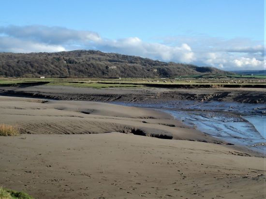
I find myself climbing a minor limestone cliff on a ‘footpath’ in the environs of Silverdale. That was not what I wanted with my dodgy knee. I push on, having to check my position using my phone and eventually reappear onto lanes I recognise and make it back to Leighton Moss car park at the end of a grand outing.

We are a very diverse county, last week I was in the industrial eastern mill valleys. Now I’m on the coastal fringe in sylvan limestone country. Limestone knolls and salt marches around Silverdale. I should have come by train to Silverdale Station as the guide book hints at, I reflect upon that and think long and hard how I could reduce my car mileage by taking the train in future. One problem that as I live in Longridge I have to take a bus into Preston and then walk across to the station, there is no integrated transport connection. That is just an excuse. But there again they are on strike this weekend – you can’t win.

Walk 19 of Mark Sutcliffe’s guide, Silverdale and Wharton Crag. I can’t find anywhere to park at the station so drive around to Leighton Moss, the RSPB reserve and centre. As a member I feel justified using their car park. I’m the only one without a telescopic scope heading for the causeway across the march. I wonder why there is a causeway in the first place. Halfway across is a bird hide with views across the open water.  There are swans and cormorants, ducks and geese. My camera is in for repair, I am reliant on my inadequate phone so don’t waste much time on photography.DSC02390

DSC02392At the end of the causeway a lane leads up into the grounds of Leighton Hall. This was the home of legendary Lancaster furniture magnate, Richard Gillow, it is still in the family. Today it is closed to visitors, but there are sounds of shooting from the woods above. It is open pheasant shooting season, and it doesn’t sit well with the RSPB reserve below. Do these toffs still need to carry out these barbaric practices? They can be seen heading for a resplendent lunch before making a reappearance later in the day.

DSC02401

The energetic hill ahead of me soon clears my militant thoughts. At the top there are seats with views back over Leighton Hall, the marshes, limestone escarpments and far away the Lakeland Hills. What a grand day to be out.

DSC02405

DSC02414

I relax on quiet country lanes until a sudden right turn up a steep bridleway has me huffing and puffing, the path is obvious taking me into the Wharton Nature Reserve. I have inadvertently left my trekking poles at home and miss their aid and added stability on the steep rocky ground. The limestone bedrock pokes through the surface giving a slippery passage.

DSC02416

DSC02420Not sure how I find myself on the summit of Warton Crag but here is the trig point and the metal beacon. I find a place to sit and look out at the view across the sands of Morecambe Bay. Checking the surroundings for stray dogs I get out my sandwich and flask. What a place for a picnic.

DSC02422DSC02423DSC02424DSC02425

Back at the bridleway, Occupation Road an old drover’s lane, which takes me down to Crag Foot with its chimney. The chimney once served a coal-fired water pump which drained land now occupied by the Leighton Moss reserve. Rising coal prices during the First World War led to the discontinuation of pumping and waterlogging of the once very productive farmland.

DSC02419DSC02436

The path across the marshes is flooded in places, but I arrive at Jenny Brown’s Point virtually dry footed. There are good view back to Warton Crag. The chimney here is the remains of a short-lived copper smelting project in the 1780s.

DSC02435

DSC02448DSC02443

The house at the point doesn’t want people using the public right of way through their property and have a plethora of Private Signs this side. I balance past precariously outside their wall only to find more helpful signs on the other side. (I love these Peak and Northern Footpath signs which keep cropping up in my posts)  In future, I will know which way to take. Presumably when they purchased the property they were aware of the right of way, I put this down to arrogance on their part.

DSC02452

The lane is familiar to me, I could have taken paths along the cliff faces, but I’m happy to stroll into the outskirts of Silverdale. It was from there that following the guide’s route felt at odds, I was clueless as to my whereabouts and was hoping ‘beatingthebounds’ would make an appearance to direct me across Lambert’s Meadow, but I made it back. Time for a brew with Sir Hugh in nearby Arnside.

DSC02460

Woodwell.

DSC02463

The cliff path.

DSC02467

The legendary Lambert’s Meadow.

Capture

CICERONE’S LANCASHIRE – the darker side.

DSC02244

I’m being unkind there, the darker side of the Pennines is actually in the White Rose county. But it is often gloomy as you drive down through these eastern Lancashire valleys with the prominent Peel Tower watching over you.

Walk 28, Holcombe Moor from Ramsbottom promised “A non-too-demanding walk from the endearingly quirky of Ramsbottom up onto the moors and back in time for coffee and cake – or a pint – in one of many inviting bars and cafés” That turned out to be a little short on the detail, both good and bad, but we are out for adventure and discovery after all.

Ramsbottom, forget the corny jokes, is, or was a solid Lancashire Mill town. Wikipedia as usual has more than enough information. It is now an apparently thriving, on the evidence of all the people there today, shopping destination. Its strength is the number of independent businesses both basic and frivolous. Parking was not easy on a busy Saturday. The station, one of the main attractions, with sometimes steam hauled trains up the valley on the East Lancs Railway was just around the corner. Only diesels today but come later and there will be Santa Specials.DSC02246DSC02245DSC02251DSC02253

DSC02254

Relics of the past.

I’ll gloss over the first stretch through a modern industrial landscape. But all of a sudden one is out into open fields with the River Irwell alongside. I’d been here before on the  Irwell Sculpture Trail which at the time seemed very short of sculptures. Today I was noticing things new like the ‘stone hedge’ bordering a field, the nod to industrial heritage on the site of Cross End Mill, (a C19th dye, bleach and subsequent textile print works) the little allotments and a modern day communal food bank.

DSC02258DSC02269

Capture Cross End

DSC02270

The path deposited me in the isolated hamlet of Strongstry, a couple of back to back streets which must have provided housing for mill workers in the past. There seemed to be a sense of community with book banks and bird feeding stations. A nice place to live.

DSC02277DSC02271DSC02276DSC02275

Now for the interesting and unexpected bit, underplayed in the book. A scramble up alongside a lively stream in a hidden, rocky, tree lined gorge. Pure delight for 3/4 of a mile and 500 feet of climbing. Well done the National Trust who care for this land.

DSC02289DSC02283DSC02286DSC02285

Out the top and across the road the character of the walk changes as open moorland is reached with increasing views over all those industrial valleys. The arrival at the top was greeted with a plethora of signs warning of the dangers of the MOD firing range, with more regulations than you could throw a bomb at. There were no red flags or explosions today, so I could happily trip along the ridge of Holcombe Moor.

DSC02300

DSC02299

The main point of interest was a stone monument erected in 1902 on the substantial base of an ancient Pilgrim Cross. The inscriptions told of the way to Whalley Abbey in the C12th.

DSC02310DSC02311DSC02313DSC02312

From there I could have made a beeline to the distant Peel Tower over Harcles Hill, but the going looked boggy, and besides, I was following Mark’s footsteps. His way was no less boggy but had views down into the steep sided valley of Red Brook south of Bull Hill. I’m not certain I took the right track; there were so many, but eventually, I homed in on Peel Tower after an arduous half hour or so, again underplayed in the guide. It was a lot taller than I had remembered, 128ft in fact, and today, as always, the destination of many family groups coming up the short way from Holcombe. Built in 1851 with a public subscription to mark gratitude to locally born Sir Robert Peel for repealing the complicated Corn Laws, which were causing starvation in the agricultural workers. Political intrigue was as complicated then as it is today. I think of him more for his reform of the criminal justice system and the establishment of Police Constables, ‘peelers’.

DSC02314

A murky tower in the distance.

DSC02317

Arduous conditions – welcome to winter walking.

DSC02322

Bull Hill – I’ve never knowingly visited.

DSC02329

Tried an arty shot with the ‘towers’ of Manchester in the background. It didn’t come off.

DSC02332

Look at the size of the figures.

I found a good stone to sit on overlooking the valley and opened my lunch box containing my lovingly handcrafted egg and tomato salad sandwich. Placing it on the stone behind me whilst I poured some hot tea. Reaching for the anticipated sandwich, it had disappeared. I had to look twice, but it just wasn’t there. The culprit was a silent poodle who must have crept up behind me; there he was, finishing off my lunch higher up the hill. I suspect his owner was hiding out of shame.

DSC02338

There’s a dog up there…     I’m on my way down.

Rested but not fed I started to make my way down steep tracks, past a Millennium Bench, and lanes through Holcombe. A mixture of old stone cottages and extravagant new properties, the former predominating the lower I went. My intention was to stop off for a pint in the Shoulder of Mutton pub and phone the plastic bag man living nearby for him to join me in what was once one of our haunts after climbing. But alas, the place was boarded up, ‘landlord needed’. It is not a good time for pubs. So down steeply, and I mean steeply, into Ramsbottom.DSC02340DSC02341DSC02343

DSC02348

A Lowry’esque church – Holcombe.

DSC02351The streets were still busy. I was disappointed to see also that the Grant Arms in the centre had closed; I stayed there on the Irwell Sculpture Trail; it was pretty grotty at the time I must admit. It is now a financial investment office. You can see why traditional pubs suffer as quite a few small bars were scattered around, offering a good range of beers often home-brewed, cocktails and a bright environment. They were all full of happy people.DSC02357DSC02355

DSC02353

Maybe here lies the answer…

DSC02359

…more likely here in a modern bar.

I was pleased to see that the welcoming Chocolate Café across the way was still in business; it was always a haven on shopping trips. All things chocolate.DSC02358

Anyhow, a change of plan, and we were soon sat in The Garsdale on the edge of Bury enjoying a beer and chewing the fat, as they say in these parts.

A superb varied walk full of interest but a little more demanding than Mark suggests, or am I getting old? Surely not. Thanks for sticking with me.

CaptureRamsbottom.

CICERONE’S LANCASHIRE – Easington Fell again.

DSC02193

My usual ploy of a leisurely start to the day, drinking coffee, catching up with the news and maybe a crossword or two seemed to be sensible as the rain hammered down. Another coffee whilst I scanned the Cicerone Lancashire Guide for an accessible walk more testing than the Blacko one a couple of days ago, delightful though that was. (Today’s turned out to be a tough test of eight difficult miles)

This post became rather long and rambling, I can only apologise now.

I was soon driving out to Grindleton in the Ribble Valley. Several flooded roads did not bode well, perhaps I should have brought Wellingtons. But the forecast was for improvement, and I’ll go with that. The route in question , Walk 20, included an ascent of Easington Fell. I’ve been up there many times. A good friend used to live in Grindleton, and we often did circuits above the village. The last time I was up there was in lockdown 2020 when I approached from the north out of Harrop Fold. The day did not go well, and I was lost for some time (more than I would like to admit) in mist on the fell. I did not want a repeat of that fiasco. 

I parked in Grindleton which looked rather sad with both of its pubs closed. They were working on one, formerly the Buck Inn, but progress is slow. The Duke of York sits forlornly on the opposite corner.

DSC02241

The Duke becoming derelict.


DSC02242

Not likely! The old Buck Inn, why the name change? Looks like corporate management.

I walk through some lovely woodlands and above the old Greendale Mill originally powered by the lively valley stream.

DSC02162DSC02163DSC02164

I found this on the internet, TCW.

In the 1850s and 60s a quarter of the adults in the village were hand loom weavers of cotton, but industrial mills were being developed apace and depriving the domestic workers of their livelihood. It would have been seen as a benefit to Grindleton when a mill was built there, providing jobs without the workers having to make arduous journeys further afield, perhaps to Preston or Blackburn. Greendale Mill was built in about 1868 by the Grindleton Industrial Association Ltd with space for 180 looms. It straddled a brook and was driven by a water turbine and a 15hp steam engine, which was powered by a huge coal-fired boiler 7ft in diameter and 25ft high. By 1871 the mill had been leased to a tenant, Timothy Marsden. He employed about 50 people and had 100 looms.

At about 12.50pm on Tuesday, September 26, Marsden was seen stoking the furnace to get the boiler steam pressure up. Two or three minutes later there was a shattering explosion. Shocked mill workers rushed out and saw the boiler house had been blown to bits. Masonry and roof slates lay everywhere, covering the surrounding fields up to 200 yards away. A pall of steam hung over the mill and the surrounding area, and there was a deathly silence.

Three or four men entered the boiler house and found the boiler had been torn from its brick setting and thrown across the room, its metal plates ripped apart, and the rivets sheared through. Timothy Marsden was lying on the floor, an oil can in his hand, gasping for air and making rasping sounds. He was severely scalded on his back, arms and legs, and he had a deep gash on his head.

The workers carried him into the cotton warehouse and a doctor arrived. Slipping in and out of consciousness and deeply shocked, Marsden asked what had happened and when told he said, ‘Poor me! What shall I do?’ With some difficulty his clothes were cut off. He asked to be taken to his home in Darwen, about 20 miles away, so he was carefully wrapped in blankets and loaded on to a horse-drawn cart for the journey. The doctor tended to the terrible scalds and the head wound for the rest of the week, but Marsden contracted lockjaw and died on the Sunday night, five days after the accident.

An inquiry was held at the Duke of York Inn, a few hundred yards from the mill, on the afternoon of Tuesday, October 14, and the jury returned a verdict of accidental death.

Damage to the building cost £500 (about £60,000 now) to repair, and the mill was not fully operational until early the next year. Cotton manufacturing continued until 1930. After that, felt was made for hats, and then engineering components. In 1960 the site was acquired by a haulage firm. It is now a storage facility. 

The area round the mill, about 20 acres, is now owned by the Woodland Trust which planted it with broadleaf trees in 2000 to commemorate the Millennium. There are a number of damson trees to reflect the fact that Grindleton was once home to a jam factory.

I thought that was worth the read.

Now on Green Lane leading up the fell. At one time this was a pebble stoned way. Bits of tarmac keep appearing to give access to the scattered houses. 

DSC02167DSC02169DSC02168

I remember White Hall from some previous visit. Its price is now £2 million. 

DSC02170

DSC02172

A touch of colour on the way.

Upwards and onwards I pass the extensive grounds and properties of Cob House. One of the grandest overlooking the Ribble Valley and no doubt valued at more than £2 million. I often muse as to who lives in these mansions, local businessman come good or a crook doing bad.

DSC02173

A little farther up a Bridleway slopes off to the left into a valley with the isolated Simpshey Hill straight ahead. My memory clicks back to 1989 when I was introducing one of my son’s to off-road ‘cycle packing’, the other son has more sense. We camped down by the little stream and were surprised if not scared by a large black mink approaching us as we cooked our beans. We didn’t sleep easy. That was the time when animal rights activists were releasing the animals from the mink farms, much to the detriment of the local otter population.

DSC02175

Simpshey Fell and valley.

DSC02178

West Clough Brook.

I worked my way around Simpshey and then Easington Fell with its forest appeared, it looked a long way. In fact, I ended up walking continuously uphill for nearly 4 miles and was glad of a sit down on an old wall for a bite to eat. From up here Pendle was prominent on the horizon, as always, and swinging round the Bowland Fell were all a bit hazy in the moist atmosphere.

DSC02182 (2)

The long way up to Easington Fell in red.

DSC02184I knew that the next section around the north side of the forest would be hard going. I aim for a pile of stones, marked as ‘The Wife’ on some maps.

DSC02188

The wife.

From there is rough ground, climbing the ‘rusty gate’ mentioned in Mark’s guide, up to another pile of stones marking the summit of Easington Fell, 396 m. (Header photo) The good views into Yorkshire and the Three Peaks were obscured, but I could see my way along the plantation edge. What is not readily apparent is the condition of the ground, it deteriorates into a reedy boggy nightmare where I was concerned I would sink without trace. By now the wetness had spread up to my waist, and I was tiring in the heavy going. I was looking for a way through the forest and was concerned it maybe blocked by all the storm damage from last winter. The easy option would have been to continue outside the trees on an undulating course to Beacon Hill, but I was keen to follow the guide. An indistinct post showed the way into a fire break which thankfully was clear of fallen trees.

DSC02191

That rusty gate – first of many obstacles.


DSC02205

Distant Beacon Fell.


DSC02206

Rough going – what lies beneath?

DSC02202

DSC02201

Trouble ahead?


DSC02208

That elusive fire break.

At its end I joined the Shivering Ginnel, an ancient walled route through these hills. ‘Shivering’ because it was so often a cold north-easterly wind that blew through here.

DSC02209

Shivering Ginnel.


DSC02210

How many have passed this way.

It was a relief to break out onto the open moor at Beacon Hill. The ground around the summit seems to have been disturbed, mining activity or a more ancient burial ground? Does anybody know?  Pendle has to appear in the background of the Summit photo. The River Ribble is somewhere down below.DSC02212DSC02217

DSC02213I’m soon off the fell and on a lane past Scriddles Farm. Don’t know the derivation, but we have had some lovely S’s today – Simpshey, Shivering and Scriddles.

Across a stile is a ‘Shepherd’s Hut’ with a great view and the obligatory ostentatious hot tub – but who uses these bacterial baths especially with a public footpath coming through. DSC02219

DSC02220The next mile or so was not the best, unmarked paths and crumbling stiles. To make matters worse the afternoon light was rapidly deteriorating. I followed this way in reverse a while back with Sir Hugh and The Rockman, we struggled then but the intervening years have not been kind to all those stiles. Most were difficult and a couple downright dangerous. The guide underplays this section, some acrobatic agility is needed together with the more detailed 1:25000 map, I resorted to phone navigating technology and the landowners could be more helpful.

DSC02222

Slowly rotting away.


DSC02224

Rights of way have a knack of disappearing in horsey country. I’ve nothing against horses.


DSC02225

Somewhere down there.


DSC02226

Don’t look down.

I was glad to reach the ancient sunken track leading straight back to Grindleton.

DSC02233

DSC02227

Jelly Ear fungi – edible but just too nice to pick.


DSC02166

Any ideas?

There is a choice of ways through the village – the Main Street with some impressive houses.  or the back ally with its cottages. Little ginnels run between the two, and I notice there is a marked trail around the village.DSC02236DSC02237DSC02239DSC02238DSC02240DSC02159

A pleasant place to live apart from those two derelict pubs. 

CICERONE’S LANCASHIRE – Gentle Pendleside.

DSC02123I

It’s been a while since I walked alongside Mark Sutcliffe, he of Cicerone’s Walking in Lancashire guide. Apart from a short road walk around Longridge Fell with JD the other day I’ve languished in the house. Time to get going again and test my knee out. I scan the chapters looking for something undemanding. I toss up between Blacko hills, (Chapter 27) and the Clarion House walk on Pendle. The former looks the easiest, even if the latter looks the more interesting. The fact that it was Halloween Eve never crossed my mind as I delved into Pendleside. On reflection the immediate Pendle area would have been chock-a-block. (I like that word)  Lucky choice.

My mood in the morning was as gloomy as the weather, but I had enjoyed that extra hour in bed. The weather improved alongside my mood, I was just glad I was in the car post walk when the afternoon deluge hit the area. The M65 virtually came to a halt as the skies blackened and gallons of water came down from somewhere. I’m now safely home.

Let’s park up at Higherford, there is a bridge here now over Pendle Water. I struggle with the car park machine, ‘it’ knows I’m here and will charge me later on my return – that preys on my mind for much of the walk.

Across the way is Pendle Heritage Centre. I think I was too early for its attractions – tearoom. gardens and museum. Maybe later but then it is too late. Park Hill House below has associations with the Bannister family later to run the sub 4 minute mile. I do spot the first Tercet on The Lancashire Witches Walk .DSC02105DSC02104

Alongside the water I get into my stride. Autumn is everywhere. There are reminders of previous mill operations, but I am soon out into the countryside.DSC02114DSC02119DSC02120

DSC02118

DSC02122

I’m heading towards Blacko Tower.

 A plaque reads Built by J Stansfield1890 Restored 1950. Approximately 30ft high. Built as a folly. Circular. Coursed rubble. Widely spaced battlements. Two steps up to a plain doorway. Spiral stone staircase inside leading to observation platform. Prominent hilltop landmark. 

Such a shame there is no public access, it must be a fine viewpoint. Time for the citizens of Blacko to stage a protest march. I make a mental note to return mid-week and make a clandestine ascent.DSC02127

Today I’m content to follow vague contouring paths on the rough hillside past farms to Malkin Tower Farm. Maybe the site of a ‘witches coven’ in 1612 from where the women were marched off to Lancaster to be tried and executed. There is lots of speculation as to the true version of events. All is quiet today with the farmer’s wife subtly showing me the diverted way. A few arrows would have helped, but all is mysterious around here. DSC02129 At the next farm I weave through a complicated series of gates in their garden. Enquiring of a lady, to confirm my way, that few people walk through here – she says “most get lost”. I doubt the irony strikes her. Again a few yellow arrows wouldn’t go amiss. At last, I’m free and walk down a lane to another farm, Whitemoor Bottom. The guide says take the footpath on the right, but there is no obvious way –  I strike boldly through the farmyard and onwards down the fields. This is horsey country and barriers keep appearing, is it this side of the wires or the other? Determination sees me through, and I drop into a wooded gully with little sign of others coming this way. But I’m on course and eventually come out onto a lane at Holly Bush Farm. Sand Hall, which looks as though it should be listed, is passed, and the lane takes me to Foulridge Reservoir.DSC02132DSC02135

DSC02136

Time for lunch, so I climb up to the dam for a bird’s eye view of the reservoir. It’s depleted of water and the only action from the sailing club is a model yacht race.DSC02137DSC02144

A bridle way takes me to join the canal as it emerges from the mile long Foulridge Tunnel, completed in 1796! A way mark confirms it is the Leeds – Liverpool Canal. Maybe I should walk its historic length one day.DSC02146DSC02149DSC02150

DSC02154

Halfway down the locks a path takes me through a pasture and into an upmarket estate. As I progress down the main road the older stone houses typical of these mill villages appear, Weavers cottages now desirable properties. On the corner by the packhorse bridge is the old toll-house (early C19th) with a board listing prices – almost as complicated as the pay machine in the car park.DSC02115DSC02106 (2)DSC02107

A good start to my winter walking, shorter than the guide book suggests, and not a ghost or witch in sight.

DSC02121

*****

Foulridge

CICERONE’S LANCASHIRE – back on the trail.

P1090151It’s two months since I was last able to do a walk out of Mark Sutcliffe’s guide book. Finding one locally I strode out today on his Jeffrey Hill chapter. The suggestion was to park at Little Town Dairy, a farm shop, nursery and café. I feel guilty using a businesses’ car park if I’m not giving them any business so I parked by the road higher up on the route, which was to prove tiresome later in the day.

I had reservations about the initial route through the upmarket barn  conversions at Dilworth Brow Farm, previously a run down property. There was no need to worry, the path through was obvious, and even the local dog was friendly. Every farm seems to be erecting holiday lodges, Is this a result of the recent ‘staycation’ mentality?

P1090114

An uncertain start.

P1090117

Dilworth Brow.

P1090122

Once into fields I could enjoy views over the Ribble Valley and distant Pendle as I dropped to an ancient bridleway. Being enclosed and sunken this was once a boggy mess, but drainage has been installed and an upgraded grit surface added. This was only a short section of the right of way, one wonders why certain paths are improved (a further one later) when others are neglected.

P1090126

Note the size of the left-hand gatepost.

I made the obligatory short diversion to view the Written Stone, I have written of this before,excuse the pun. A car passes down the farm lane, I thought I recognised friends from years ago and regretted not stopping them. As I walked through the tidy environs of Cottam House I asked a man about the history of the place, he turned out to be the son of the above couple. So we had a catch-up, I passed on my regards and walked on.

P1090129

The Written Stone.

P1090130

This was the start of a slow climb back up to the ridge of Longridge Fell. Rough ground skirting the golf club and then the road up to Jeffrey Hill at Cardwell House. A large walking group was coming past and didn’t seem over friendly, head down mentality. There was a straggler taking some interest in his surroundings. We ended up in a long conversation about all things, as he said “it’s not dark till late”. I felt he had lost connection with the route march he had been on. Nobody came looking for him.

P1090133

Up to Jeffrey Hill.

P1090137

The Ribble Valley and Pendle.

P1090140

No time for stragglers.

I took a picture of the iconic view which I mentioned in a recent post. A ‘glass wall’ has replaced the iron railings depicted in the painting I own from 40 years ago.

P1090145

That view from Jeffrey Hill.

Nearby was a bench for refreshments. Some stones had been intricately carved as part of an art sculpture from 2014, It was a shame they removed the star of the installation, the Sun Catcher.

P1090142

Remains of the sculpture installation.

Now steeply downhill, look at the contours, ending up on the road at Thornley Hall. The ford leading off the road was surprisingly full. The next bit of track starts as a track but quickly becomes an overgrown narrow path, the book advises a stick for hacking back the vegetation. I happily swashbuckled my way along and at the end came onto another strange short stretch of gritted path.

P1090150

Looking back up to Jeffrey Hill.

P1090154

The listed C18th Thornley Hall.

P1090157

The ford.

P1090158

A promising start to the bridleway…

P1090165

…soon becomes this…

P1090168

…and then unexpectedly this.

Familiar lanes took me past Wheatley Farm and a house that always has a splendid floral display. Onto the busy main road where care is needed on the bend. I was glad to be back in the peaceful fields of Chipping Vale under the Bowland Hills. Heading towards Little Town Dairy where I could have parked at the start, but no I was faced with another steep climb back onto the fell. I reckon I had climbed over 1000ft in the 7 miles which took me 4 hours including all those stops.P1090169

P1090172

Wheatley Farm, 1774.

P1090174P1090175

P1090177

One has to spend one’s money on something. 57 has gone shopping.

P1090178

Parlick and Fairsnape.

There was one more encounter at Sharples House. The farmer there had previously talked of having the largest cheese press in Lancashire, I believed him. In the past many farms in the area made their own cheese, tasty Lancashire. Today he seemed in a good mood, so I enquired further, and he took me to see the stone, it was indeed large and must have weighed a ton. He explained that the house was from the late 17th century. A former occupant, a Peter Walken (1684-1769) had been a nonconformist minister as well as a farmer. Uniquely he kept a series of diaries, most have been lost but two from 1733-34 have been found and published by a researcher from Preston museum. The present farmer was contacted and was able to see the journals but described them as boring, though they must have given an insight into farming life in the first half of the 18th century. He also told me of a mystery from the last century when two thieves broke into the house killing the farmer, but the daughter perhaps escaped hiding in an adjacent barn. One wonders how much local history has been lost.P1090183

There is another mystery just along the lane at Birks Farm – what is this structure in the wall built for? I should have asked the last farmer, next time.P1090184

Up the steep lane, over the last stile and I finish this splendid walk back at my car overlooking Longridge.P1090186P1090189P1090190

***

Capture

CICERONE’S LANCASHIRE – To the points.

I’ve never been fully around Sunderland or Bazil Points so walk no 18 in Mark Sutcliffe’s Cicerone Guide to Walking in Lancashire was an attractive proposition especially as it was flat as a pancake which suited my crumbling body.

I have a fear of rising tides, so the logistics for this walk were important. Tide timetables were consulted and double-checked, last Saturday looked good with a low tide at 9am. Unusually for me, I was parked up at Overton at 9am. Would my car disappear under the waves whilst I was out, I said I was nervous about the tides around Morecambe Bay. Remember the disaster in 2004 when at least 21 Chinese illegal immigrant labourers were drowned by an incoming tide whilst picking cockles off the Lancashire coast.

There was little sign of water as I walked across the causeway, just mud and marsh grass in all directions. The Sea Thrift gave the area a pink glow. A few cars passed heading to town. Soon I was at the few houses that call themselves Sunderland, once the major port for Lancaster and beyond. I wrote of the history of this place when I visited in October last year.

That time I was on my cycle so didn’t go right round the point itself. Today I continued past the last house onto the rocky shoreline and found a place to sit at the very end looking out over the Lune to Cockerham and distant Knott End. There was Plover Lighthouse seemingly on land today. As the tide was well out there were virtually no waders on the shore, just the odd shelduck, but curlews were calling in the fields behind me and goldfinches flitting through the gorse bushes. A local lady walked by and talked of the unique life here. I enjoyed the peace and the view knowing that when I turned the corner Heysham power stations would dominate the landscape.

Glaucium flavum only found on the coast.

I passed by Sambos Grave and the Camera Obscura, I couldn’t resist going inside for the upside down view. Cows were grazing on the marshes. A wild rose had the most delicate perfume.

Up at Potts’ Corner more people started to appear on the sands, presumably from the nearby caravan parks. Here I joined the zigzagging lane for half a mile before cutting across fields to use the sea wall leading back to Overton. The village is a cluster of cottages on an elevated site above the Lune. Some of the properties dating back to the C17th when it was a farming and fishing community.

I walked on to the church, one of the oldest in Lancashire. It was locked, so I couldn’t view the interior box pews and balcony. I found a seat near the Norman doorway and ate my sandwich looking over to Glasson. Then along came a gent in a tweed jacket, shorts and trilby, he cycled in to get some photos of the estuary as the tide comes in. Turns out we had mutual interests and spent a pleasant half hour chatting about this and that.

There was an old lane leading down to the shore from where at one time a ferry crossed to Glasson which looked very close. I walked around Bazil Point on the edge of the rocks, which would be difficult if the tide was in. Each gate on the way has a smart red sign. The point was as atmospheric as the one I’d walked this morning and as the tide raced in the surface of the water displayed a silver shimmering which I found mesmerising.

Ferry Cottage – considerably modernised. What a situation.

Looking back to Bazil Point.

At one stage I left the beach to walk in the fields, though I later found I needn’t have. The path left the field by a most unusual high stile down to the beach. By now I was surrounded by a herd of cows with a sturdy bull coming my way. I was glad of the escape route.

The bull is prowling at the top.

And then I was back at my car, still above the waters. What a magic area this is and well represented by Mark’s walk.