LANCASTER CANAL 8. Sedgwick to Kendal.

For our last day the sky was blue, the ground hard with frost and the surroundings covered in snow – magic. Of course this was all planned.

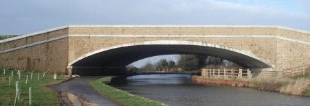
We were soon back up to the line of the canal and making good progress through the fields on the edge of Sedgwick which seemed to have some pleasant housing tucked away from modern hectic life. The village first enlarged due to the nearby gunpowder works on the River Kent, subsequently residential properties have been built in what was probably the estate of Sedgwick Hall mentioned in my last post. The canal crosses a road on a skewed aqueduct in the middle of the village, these were built for strength.

Lovely countryside was traversed with drumlins to our right, isolated bridges and then woodland giving variety.

Looking to the east above St. Marks Church in Natland was an attractive Fell I didn’t recognise, looking on the map it is named The Helm and has an Iron Age Fort [Castlesteads] at its southern end. Yet another place to explore on a return visit.

Onwards under more isolated bridges with the lower Kentmere fells  in the background. This area is well walked being just a stroll out of town.One can see why Kendal is a popular place to live – a lively historic town in beautiful surroundings.

And then we were into the streets and parks of Kendal, the line of the canal still walk-able with frequent signs. A walking cycling corridor out of town. Passing behind the leisure centre the site of old coal wharves has been utilised by local schools to provide environmental studies. 


One renovated bridge had iron work alluding to the history of rope-making  hereabouts.

A crossover bridge is encountered and duly crossed, there have only been three on the whole of the canal. Obvious old mills are passed, the castle is up to the right somewhere. More filled in wharves at Lound, with informative interpretation boards,  and then the main terminal basin is reached, now only identified by warehouses. These are now used for other purposes though some have links back to the past. A small building is signed as being the original ticket office for the packet passenger boats. In the last warehouse, now modernised, is the head quarters of Gilkes manufacturing turbines on this site since 1856. Apparently inside are some original features of the basin.One can only imagine the industry and flow of goods right in the centre of Kendal in the 19th century. A return visit is needed to explore this industrial heritage further.

Below is an old aerial shot of the terminal basin [Stricklandgate House Trust]


Our way across Gooseholme Bridge was closed due to flood damage, so we braved the traffic on a road bridge to reach Baba Ganoush for a welcome bowl of delicious soup. This was followed by the three of us ‘running’ to catch the 555 bus, thanks to the driver for waiting for us.

So my journey up the canal from Preston is completed. It has been a very pleasant stroll helping my hip ligament rehabilitation but more than that has been full of interest and kindled my desire to explore this area further.


LANCASTER CANAL 7. Holme to Sedgwick.

We were the only ones stood waiting for a bus on the deserted slip road off the busy A590 roundabout but sure enough the 555 appeared and took us back to Holme and bridge 149 on the canal. Driving up the motorway this morning the snow covered Lakeland mountains looked majestic, blue skies and bright sun promised a good day – on the Lancaster Canal not those mountains.  I have just realised we are now walking in Cumbria so ignore my tagging of Lancashire, somebody moved the boundaries.

Today’s stretch is along isolated truncated parts of the canal which in its demise suffered at the hands of the road builders, notably the M6. Despite this there were some beautiful stretches of countryside as well as awful noise from the motorway.

The start on the edge of Holme is dominated by Farleton Fell to the East. we could trace defunct tracks used to bring limestone down from quarries to the canalside basins. Over to the west the cliffs of Whitescar were prominent with the Coniston range behind. Soon the canal was blocked by the M6. A diversion through fields alongside the motorway to a crossing meant backtracking, for the sake of completeness, to the point where the canal emerges from a culvert under the road. Swans were starting to nest build on this watery cul-de-sac. I recall the kingfisher that flashed past somewhere back near Galgate, haven’t seen much else but ducks, oh and the odd Heron.

Through Farleton remains of one of the stables used for the ‘fast’ packet boats was passed, horses were changed every 5 to 7 miles to maintain momentum. Remember, as the cars speed by on the M6 and trains on the nearby main line, the 57miles from Preston to Kendal took passengers 8 hours. The industrial haulage was more like a week for the round trip.

A little further on and there was an aqueduct over Farleton Beck, I dropped down to view the structure and found what appeared to be a fish ladder next to the beck, but I think is just an overflow from the canal.  Notice the first use of beck, a Norse word for stream used mainly in the north of England.

Another stretch by navigable water ended at a culvert under the A65, we used the underpass and again a short while later at the M6 again. There is no way the Northern Reaches of this canal will be restored. History is littered with bad, short sighted planning decisions. We are still making plenty of them unfortunately. In between on the short section of canal swans glide regardless of the situation. 

From here on to Stainton the canal is navigable if you can get a boat into it. The only craft we saw was the Lancaster Canal Trust’s small boat moored at Crooklands. The main canal feeder from Killington Reservoir enters, disappointingly as a mere trickle through a fence bordering an industrial unit. Killington Lake is known to many for its M6 service station on the way south. Up to 17 million gallons of water a day enter the canal here!

There is an aqueduct over the Peasey Beck which supplied the gunpowder factory mentioned below and is interconnected to the Killington supply. In the vicinity we passed a canal side coal wharf and the larger Wakefield’s wharf which was connected by a tram-way to a nearby gunpowder factory at Gatebeck, yet another place to explore. Saltpeter and sulphur came from foreign lands but the charcoal and water power were local.

Wakefield’s Wharf.

Lunch was taken at the Canal Trust’s restored packet stables but was interrupted by a short hail storm  on an otherwise sunny cold and clear day. Looking back on our meandering route Farleton Fell looked surprisingly close.

The section northwards was through glorious English countryside and would be a joy to canoe.

Another small feeder comes in and then an aqueduct over Stainton Beck. Storm Desmond two years ago caused serious damage to the stonework and repairs will be costly.

The semi functioning canal finishes  finally at a damn where the water no longer exists. The next length of canal, optimistically named First Furlong, is being cleared and re-puddled with the hope of returning to water. But a few volunteers will be no match for the hundreds of navvies working two centuries ago.

A dry section can be followed to the entrance to Hincaster Tunnel, the only one on the canal, When built to go under the hill there was no towpath so horses had to be taken over on the path we now follow. There is much interesting stonework associated with the canal structures here and the modern railway goes overhead. How often do the railways parallel the canal? Down the otherside is another packet stable.

A short stretch by the dry overgrown canal course is made interesting by installations of models, figures and other artifacts introduced no doubt by some local children who may have been involved in the clearing of the ‘towpath’. A nice touch much appreciated.

The canal has been demolished by the A590 and a lane is taken. Below is the estate of Levens Hall, which is well worth exploring. A short climb brings us up to the course of the canal, now in filled, and a field crossed to the obvious isolated canal  bridge,177. We are above the interesting Gothic like Sedgwick Hall which was previously a school and now converted to individual living accommodations.

Our car is not far away leaving us a short section of ‘canal’ to complete into Kendal.

Corniest boat name of the day category. We only saw one boat all today … Waterwitch, it will have to do.


LANCASTER CANAL 6. Carnforth to Holme.

A highlight of the day was a flash of turquoise – the first Kingfisher I’ve seen for a year.

Progress up the canal is being made slowly with my self imposed limit of 8miles flat walking, however there is no deterioration in the hip ligaments which are improving with my physio exercises. fingers crossed. I have just realised that in 60 years of walking and climbing this was the first time I’d sought the help of a physiotherapist.

Today’s companions were Peter and Denise again. My car was left at Holme and the bus taken back to Carnforth. I’m making good use of my bus pass on this walk, maybe this could be developed into a theme. There is one blogger I’ve come across who ticks off the Wainwrights using only public transport, well not the summits themselves but just getting to the areas.

We meander out of Carnforth with interesting road and railway bridges. The first bridge as we leave the town has been sympathetically widened at some time to accommodate more traffic. Bridges under the motorway are more brutal.

Rural calm returns as we reach the aqueduct over the River Keer, the converted mill below has a restored waterwheel and was coincidentally almost purchased by Peter and Denise when they moved to the area. Looked a bit dark and damp to me. Old milestones are visible along this stretch, 17miles to Kendal!

At nearby Capernwray we were entertained by a tractor trying to manoeuvrer a mammoth caravan down the lane under the railway bridge. The attached holiday site is in an old limestone quarry, Wegber, with cranes still visible and a little further a short canal branch into the quarry area for loading the limestone.

We passed by Borwick Hall, just visible through the trees on the other side, an Elizabethan manor house. And then we were at Tewitfield a significant location on the canal. So far I’ve walked 42 miles dead level on the 70ft contour but today things change and the canal, now defunct, rises 75ft in half a mile. This northern section to Kendal was opened in 1819 and was closed in 1968 with the building of the M6. 8 locks lifted the canal from the basin before level going to Kendal. The basin where the canal navigation now ends is a holiday complex with not particularly well-designed apartments.

END OF THE NAVIGATION.

Creeping alongside the motorway we reach the start of the ascending lock system. Plans have been muted for years to restore this northern section but they have come to very little.

At the top of the lock system the motorway delivers the final ‘coup de grâce’ …

We find a way across the M6 and resume our stroll along the towpath as if nothing had happened. Ahead was the distinctive outline of Farleton Fell, once one of our popular evening climbing venues on less than solid limestone.

Passing the settlement of Holme Mill we saw the millpond supplying a once industrious linen mill. Flax was grown in the area for the production of linen before King cotton took over.

We didn’t enjoy the boggy stretch of ‘towpath’ ahead…

However, there was a final triumphant flourish on arriving in Holme with the appearance of well-preserved coke ovens on the far bank. I mentioned these in my last post when we were unable to identify any. The ‘beehive’ ovens were used to produce better firing smokeless fuel from coal for the use of blacksmiths and bakers, and later for iron smelting.

Turned out to be an interesting day. Will be back to bridge 149 as soon as possible to complete the journey.

There were few boats on this section of the canal so my ‘Corniest boat name of the day’ has become ‘corniest boat of the day’

‘Sheds R Us’

LANCASTER CANAL 5. Lancaster to Carnforth.

Another change of personnel today,  JD joined Peter and I on a windy morning. The highlight of the day was crossing the Lune Aqueduct on the edge of Lancaster. The walk from the pedestrian bridge [103] in town was through the rather dull suburbs but by the time we reached the aqueduct open countryside was visible, or at least a golf course. Rennie’s aqueduct opened in 1797, after 5years construction, to much acclaim. There are five arches scanning 70ft 50ft above the Lune. Recently there has been a significant refurbishment with improvements to the lining and the stonework. We should have descended the steps to view the structure from the river bank. Instead  we strolled over the exposed towpath made safer by the ornate balustrade. Lancaster castle was glimpsed downstream. Lunesdale upstream.

The next landmark was the new ‘milestone’ bridge carrying the M6 relief road to Morecambe.  This was a massive structure compared to the usual arched stone bridges. One of the latter in the vicinity has been widened more sympathetically to accommodate the road, a date of 1921 is visible.

Along side the canal every 6-7 miles or so were stables for the fleet of horses enabling the ‘fast’ passenger boat from Preston to Kendal, done in 8 – 9 hours. The masonry remains of one is next the towpath, easily missed.

Through Hest Bank and Bolton-Le-sands we seemed to hover drone-like above the houses with views across Morecambe Bay. At one time ships would harbour on the Morecambe Bay coast here with goods to be transferred up to the canal, the opening of the Glasson Dock branch in 1826 superseded this. Somewhere between the two villages is a good example of a swing bridge, now leading to private houses. We contemplated on how it would be interesting to withdraw access to unwanted visitors by a swing of this bridge.

I was on the lookout for old coke ovens at two sites into Carnforth, bridges 125 and 127, but disappointed with the outcome. No real sign of the beehive structures across the other bank, the low sun making visibility difficult. The ovens were used to produce better firing smokeless fuel for blacksmiths and bakers and later for iron smelting. They are supposed to look like this…

The basin to the south of Carnforth was busy with boats and dog walkers but before we knew it we were back in a rural setting before the children’s playground announced bridge 128 on the Kellet road. Time to find a bus back.

Corniest boat name of the day…

LANCASTER CANAL 4. Galgate to Lancaster.


Today Peter’s wife, Denise, joined us for a shorter walk along the canal into Lancaster. It didn’t turn out as short as expected. Having completed our walk we caught an early bus back from Lancaster. As we were leaving the city several police cars, ambulances and a fire engine overtook us with lights flashing and sirens blaring. There was obviously trouble up ahead, possibly on the motorway but soon we were stopped and the A6 closed due to a serious accident. We were going nowhere. Students alighted from the bus and started walking up a side road and cycle path into the University. There was no choice but to follow and soon we were wandering through the extensive campus hoping to bypass the closure and walk into Galgate. This proved an interesting diversion, even getting a close up view of the silk mill there. The Air Ambulance helicopter was in action so I hope those involved in the accident are not seriously injured. Will donate to their charity on the next occasion.

Anyhow to get back to the start. Smoke was drifting up from several residential boats moored in the basin at Galgate. I noticed on a wall a bank of post boxes for the boaters, I suppose you need some sort of address for communication if you are permanently living on a barge. The usual gentle meandering walk took us into the countryside on what was a dull day so views to the hills were limited. Conditions under foot varied. Occasional roundels indicated we were sharing the route with a named walk, A Breath Of Fresh Air, which takes in interesting areas of the Lune, coast and canal around Lancaster. http://soulfulhorwich.org.uk/abofa/index.shtml

After just over a mile we entered the wooded Deep Cutting which takes the canal through glacial deposits to avoid a long detour, quite a contrast to the open land. Apparently this is the place to see kingfishers but not today.

At its northern end the outskirts of Lancaster are reached. On the left at the entrance to a new development, Aldcliffe, the old gate house has been left to rot, shame. On the contrary there are some splendid houses on the other bank. Glimpses of the castle came into view. After passing under the main railway line city centre wharves were  reached. On the right was the converted boat house where packet boats were repaired after being lifted into the upper floor. On the adjoining ex British Waterways yard are new developments with the old crane preserved. The tall chimney is the hospital incinerator. At one point we have to cross over to the other bank for a short distance, the bridge is constructed to allow the horses over without unhitching. Student accommodation has been built alongside the canal and with a few pubs in old warehouses the area has a good ambience. A lot of money has been spent in Lancaster in the last few years and by look of things quite wisely. There is a fine bridge bearing the name of a local blacksmith at the time, 1876, when the bridge was widened.Leaving the canal at a pedestrian bridge, we wander through streets to board the ill fated bus.


The Silk Mill back at Galgate …


Corniest boat name of the day…

The forecast is not good for the next few days so I’m not sure when I’ll be out again for episode 5, anyhow I think my hip needs a rest. I’ll just stick to the exercises my physiotherapist has given me.


And for completeness our homeward detour…

LANCASTER CANAL 3. Garstang to Galgate.

My friend Peter from Forton got wind of my travels up the canal and volunteered to accompany me on the next stretches, he has a wealth of historical local knowledge so I readily agreed. I came away far better educated but with less photographic evidence due to all the chatting!

As I descended from the bus, there is an excellent service linking Preston with Lancaster on the A6, he was there and understood my need to retrace my steps along the Wyre to the aqueduct to regain the canal up the steps. Nearby they were dredging the canal, a continuous task I presume, some of the detritus was on display.

On the far side was Garstang Basin, now a marina. The Tithe Barn building, converted to a pub, predated the canal and was brick built.

A pipe bridge carries water from Barnacre reservoir to Blackpool.

The canal was busy with a few boats moving about between the smart marinas and moorings, the towpath also seemed popular with dog walkers. Not all boats are equal.

Peter was keen to find the site where the Garstang to Pilling railway line crossed the canal – I think we found it at bridge 65, now demolished. This line was known as the Pilling Pig from a locomotive whose whistle squealed like a pig. It connected the agricultural land of this part of the Fylde with the railway network until the 1960’s. The remains of the bridge…

We were soon into pleasant wooded countryside, lots of curves guided us through the nebulous area of Cabus. All very pleasant. Despite the temperature being just above zero we were soon taking off layers as there was no wind and hence no chill. We reached Ratcliffe Wharf another busy marina but at one time important for shipping of coal and lime. Just north are mounds, the ‘obvious’ remains of lime kilns responsible for this trade.

Forton lies a mile southeast of Bridge 79. Apparently it became the richest village in England due to the payments received when the M6 motorway was built. The small basin at Richmond Bridge was constructed for transporting stone from the nearby quarry, which is now disused.

The bridge leading to Ellel Grange is more ornate in keeping with its stately surroundings. There is a strand of lovely trees by the canal at this point – all very picturesque.

A little further, the miles go quickly on this flat terrain even with my poorly hip, is the junction with the Glasson Branch. This links via 6 locks to Glasson Basin and into the sea through Glasson Dock. This was a vital link into the canal when Glasson was an important port, superseded by Preston in due course. I should return sometime and walk this section. At the junction a graceful bridge carries our towpath over the branch. Close by is the lock keeper’s cottage and today his wife was tending the garden and gave us a potted history of the area in that lovely Lancashire drawl.

Soon we were in Galgate, another canal basin, and waiting for the bus home, the pub by the bus stop sadly closed as is the lot of many village inns these days. Galgate was the unfortunate scene of severe flooding of the river Condor just before Xmas and many of the cottages are drying out – a long process.


Corniest boat name of the day…


LANCASTER CANAL 2. Woodplumpton to Garstang.

Overnight frost has frozen the surface of the canal, ducks are flying in and giving impromptu off balance ballet displays. Sets me thinking about hard winters when thick ice would have closed down commercial travel on the canal. The sodden towpath is a little firmer though. From the start this is countryside walking with the canal weaving its way on its 70ft contour. There has been little need for cuttings or embankments. To the east are the rounded Bowland Hills, when will I be back up there looking down on this landscape?

The peace is broken now and then by cars using their horns on the approach to the humped  narrow canal bridges, I’ve never really understood this – why not just drive slowly in the first place. A few bridges show signs of damage where there has been a collision with speeding honking motorists.

There have been several designs of bridges with variation in the pitch of the arch. All are in local stone and some have railings on the parapets. Some have been built as a purely functional road bridge. There are a few wooden swing bridges serving farms and fields. As mentioned they are all numbered in sequence from the south.

An hour’s walking brings me to Guy’s ‘thatched hamlet’ with its eateries and leisure facilities, somewhere to be avoided in the warmer months when it is overrun with families. Today is all peace and quiet as I pass by on the now well surfaced and well used towpath through Bilsborrow  to arrive at the next tourist trap, Barton Grange garden centre, marina and the new ice rink in construction. The latter looks completely out of place and scale next to the canal, though the pink insulation will be covered in more sympathetic cladding.

From now on the canal runs in close proximity to the A6 road, the main railway line and the motorway so there is constant noise. Also in this communications corridor are many power lines, the anglers attention is drawn to them by signs on the bank. I am surprised at the number of lines encountered and presumably hardly noticed in daily life.

So far today the canal has used three aqueducts to cross over rivers coming down from those Bowland hills. Each has its own unique architecture and I marvel at the ingenuity of the early canal engineers. The three arched Hollowforth over Barton Brook…  the larger Brock…

and the plain Calder…

The canal has some gentle curves and passes attractive woodlands as it loops around to pass Greenhalgh Castle before entering the suburbia of new housing.I escape at a final aqueduct over the River Wyre, dropping down to pass under the canal arch to follow the river through converted mills to catch my bus in Garstang.


Corniest boat name of the day…


LANCASTER CANAL 1. Preston to Woodplumpton.

As the crow flies this section would only be about three and a half miles but the canal does a large loop towards the Fylde, an extension to Fleetwood was originally planned. My plan was for an easy level walk on the towpath and this worked well until out in the country where the boggy terrain was extremely troublesome, why didn’t I anticipate that. I was trod in lightweight trainers which quickly became sodden as I slithered around in the mud cursing my stupidity. But the sun shone and it was a glorious day to be out so the benefits outweighed the negatives.

Dismissing the Ribble Link and the Tramway across the Ribble the canal now starts in Aqueduct Street, that’s a clue to its former route through Preston Town centre. Some inauspicious steps lead to a grubby basin with no room to swing a cat never mind turn a boat. I guess no one comes this far on the water. A finger post gives distances, there is only one way.

The towpath is on the left bank and I think remains so for the length. On the far side are waterside houses. In the background is the iconic St. Walburge church spire, the third tallest in England. Housing lines the cutting and above is another iconic Preston site Tulketh Mill with its towering brick chimney – cotton was king.

The first bridge is numbered 11 so a lot have been lost. I creep under Blackpool Rd. reputedly a good place to see kingfishers and on to the edge of Haslam Park. Bridge 13 is the first aqueduct, here above a diminutive Savick Brook which remarkably hosts the Ribble Link further on whose basin and locks are soon encountered. I’ve been this way before.

More pleasant housing on the right bank is passed, I could well imagine canal side living with a canoe to take me shopping. Bridge 17 gives access to a lovely cafe and the busy UCLAN sports grounds. Massive housing developments are taking place on the far side, Cottam. At last open countryside is reached. a former farm swing bridge has been removed with little trace. Salwick Hall is seen across the fields to the right, what must they have thought of the construction of Springfields BNFL plant nearby. One of my climbing partners spent most of his working life there producing Nuclear Fuels. ‘Reassuringly’ signs by the canal tell you what to do when there is a nuclear catastrophe.

A cutting takes me safely past and at bridge 26 is The Hand and Dagger Inn, not yet open this morning and I suspect with a change of name no longer a canalside pub but an eating ‘place’. The mud kicked in by now as I ducked under the busy M55 with distant views of the Bowland Fells.

The milestones are not all intact but those that are prove useful.


Further on there is a marina hiring out and selling boats, a friendly worker is busy cleaning his stock. Further on a dog walker and I agree grumpily about the devastation all the excessive house building, often on flood plains, is having on the local area. I dare not mention fracking.  Crossing Woodplumton Aqueduct I drop down to examine Rennie’s design, apparently no two aqueducts on the canal are alike. At one point I’m listening to a tuneful bird call I don’t recognise, eventually I spot high in the branches a tree-creeper. I then struggle in the mud to complete the section to bridge 35 near Woodplumpton and a bus. Enough for today, if my hip is OK I’ll be back tomorrow.


Corniest boat name of the day…


THE LANCASTER CANAL. The Black and White.

As I said in my last post ‘I have a plan’.

I like a challenge and an objective. Since the beginning of November I’ve shelved trips abroad because of painful musculature around my left hip – brought on by excessive stress on the Cornish coastal path and in La Palma mountains last year.  My physio appointment today was positive and I’m armed with exercises to re-balance my muscles. So fingers crossed.

The Lancaster Canal is a good project in the circumstances. Flat walking and easily accessed from public transport. Walking on the flat seems to be no problem so over the next couple of weeks I hope to explore this canal system in easy sections..  I’ve never walked the full length so why not complete now.

The Lancaster Canal was a project from the 18th century to connect Kendal and Lancaster to Preston and ambitiously to the rest of England’s canal system. At the time Preston was a major port and the link north would provide coal and supplies to booming industries and limestone in the opposite direction, hence its nickname The Black and White. By 1797 a lock-less 42-mile section of the canal was constructed from Preston to Tewitfield. John Rennie was the engineer.  The extension to Kendal was completed in 1810 and a spur to Glasson Dock added in 1826. Passenger traffic on this section was much quicker than stage coach.  The southern link was complicated by the River Ribble, a tramway was built across it to gain access to the  Leeds – Liverpool system and thus an aqueduct was never built. As trade declined the last cargo was transported in 1947. The canal at its southern end now terminates in Ashton basin with a section lost in Preston’s housing. At the northern end the canal terminates effectively at Tewitfield locks as the M6 has disrupted further progress, a short-sighted but economical decision. The line of the canal can be followed northwards to Kendal.  This whole isolated canal was finally connected to the rest of the English canal network in 2002 by the opening of the Ribble Link.

https://en.wikipedia.org/wiki/Lancaster_Canal

https://www.lctrust.co.uk/the-canal/history


WALKING OFF SAD – NEEDS MUST.

Introduction…
Seasonal affective disorder (SAD) is a type of depression that comes and goes in a seasonal pattern.
SAD is sometimes known as “winter depression” because the symptoms are more apparent and tend to be more severe during the winter. The symptoms often begin in the autumn as the days start getting shorter. They’re typically most severe during December, January and February.

Symptoms of SAD can include:

  • a loss of pleasure or interest in normal everyday activities
  • irritability
  • a persistent low mood
  • feelings of despair, guilt and worthlessness
  • feeling lethargic (lacking in energy) and sleepy during the day
  • sleeping for longer than normal and finding it hard to get up in the morning
  • craving carbohydrates and gaining weight.
The exact cause of SAD isn’t fully understood, but it’s often linked to reduced exposure to sunlight during the shorter autumn and winter days. The main theory is that a lack of sunlight might stop a part of the brain called the hypothalamus working properly, which may affect the:
  • production of melatonin – melatonin is a hormone that makes you feel sleepy; in people with SAD, the body may produce it in higher than normal levels
  • production of serotonin – serotonin is a hormone that affects your mood, appetite and sleep; a lack of sunlight may lead to lower serotonin levels, which is linked to feelings of depression
  • body’s internal clock (circadian rhythm) – your body uses sunlight to time various important functions, such as when you wake up, so lower light levels during the winter may disrupt your body clock and lead to symptoms of SAD                                                                                            
  •   Treatments for SAD

  • lifestyle measures – including getting as much natural sunlight as possible, exercising regularly and managing your stress levels
  • light therapy – where a special lamp called a light box is used to simulate exposure to sunlight
  • talking therapies – such as therapy.
  • antidepressant medication.
      from  nhs.uk


Why am I telling you all this – well most winters I disappear to sunnier climes as I’ve found over the years that it prevents all of the above. As well as the improved climate I am usually involved in some semi-challenging walk giving me loads of exercise. This year I’ve been grounded because of my hip problems brought on by excessive exercise. Recent posts will have shown how I’ve partially dealt with it, sorry for the maudlin tone to those. Why don’t I just go abroad for a couple of weeks you say – well I’m not good at ‘lazy’ holidays by the pool, would probably just eat and drink too much.

Thus I’m still battling on, physio next week. So when the sun shone this morning I needed to get out. Luckily JD, of GR131 fame, phoned and within 30 mins I was at his house with a plan to do a relatively easy walk to Ribchester and catch the bus back. Off we went with bus passes at the ready.

The watery sun shone, as planned, whilst we walked past the extensive Longridge reservoirs.

The stroll down the quiet Hothersall Lane was a pleasure, as it warmed up I could feel all that lovely Serotonin fighting off the nasty Melatonin. The usual  juxtaposition of irreverent [me] and intellectual conversation [JD] bowled us along and soon we were dropping down the steep escarpment to Hothersall Lodge an outdoor centre run by Lancs County Council. Nobody was about but signs of activity were everywhere, climbing wall, zip wire, grounded canoes, archery ranges, nature walks etc. A great place to introduce people to the outdoors. We were now following the Ribble Way, a flawed route due to private fishing interests unnecessarily diverting the path higher up stream.

Further on was Hothersall Hall, a Gothic style building refurbished and providing privileged accommodation to some persons.  I tried in vain to relocate the Hothersall Boggart – a slightly grotesque stone head in the fork of a tree with associated legends. No luck today but I know its there somewhere.

All was going well with the walking until now, a good surface and fairly flat going. I had forgotten the little hill to be crossed on muddy fields – it was not a pretty sight as I struggled to cope with the terrain. Thankfully I’d brought my tracking poles, not to be separated from them these days. There were good views down to the River Ribble.

That hill!.


We had time to look across the Ribble to the extensive Osbaldeston Hall on the south bank. A path led off towards it and presumably some ancient ford crossing. JD remembered wading the river here on some previous walk but not today thank you.After that it was a stroll to walk into Ribchester, were we on a Roman Road?

Eschewing the Roman artifacts and other attractions of the village we headed past the now closed White Bull with its ‘Roman columns’ to the friendly Black Bull where we enjoyed a quick slurp of Bowland Brewery’s Buster before catching the rattly bus to Longridge.

Needs must so SAD can SOD off.  I’ve plans for the next week or so if the weather is good.


FIRST WALK OF 2018 – Longridge Fell.

January 1st 2018 – I have to start somewhere.

The phone goes late in the morning and I realise my head is still heavy. The forecast shows a two hour window break in the rain.  A quick breakfast and Mike and I are parked up with scores of others on Longridge Fell. Everyone greets us and friends are encountered. Dogs are in the majority most of them small inquisitive, nonthreatening, breeds, I can cope with.

To be honest the walking was not that great,the distant Ribblesdale views limited, the forest tracks are fortunately dry and with my poles we made good progress. The detour up to the trigpoint was not taken in view of the sodden conditions. Some recent tree felling has confused me as to our whereabouts. Eventually we wind down on the right track and head back to the carpark in cold sleet at the end of the two hours weather window. Such is the nature of walking in this part of the county. At least I’ve been out on the first day of the new year. Back to the Aga and mince pies.


LAST WALK OF 2017.

After my last post I feel I need to end the year on a more positive note. Today was sunny and dry, ideal for a hill walk but I’m still confined to flat roads. I had a plan to visit some wetlands created by United Utilities [if that is their most recent moniker] on the outskirts of Longridge. Threading my way through streets, alleys and lanes I came to the observation hides overlooking the site. I had the foresight to bring binoculars [but not a camera] – there were lots of ducks, geese and lapwings visible but nothing more. The lapwings were en-mass and looking in prime condition feeding on the marsh.  So despite the doom and gloom of yesterday’s post on Longridge being swamped with housing developments here we have some more environmental positivity.  Sadly the majority of the local population are probably ignorant of this scheme.

I will return again in 2018.

Oh! to be on those hills.

*****

THE GREEN FIELDS OF LONGRIDGE.

You may remember if you live locally a post of mine from  2014. So long ago?

Well the fears have become fact. The planners have failed us and the developers have destroyed us. That outline development map has become reality.

A walk around the outskirts of Longridge this week produced these pictures of ‘rural idyll’

As the cars queue up outside my house in this evening’s rush hour I have no further comment.


                                       HAPPY NEW YEAR!


THE GARDEN IN DECEMBER.

Well I made it through the year with my garden diary.

Today is the winter solstice, seven hours and 49 minutes of daylight if you are lucky. Its pretty grim here today in Lancashire with drizzle and mist. I missed the classic photo of the robin in the snow last week. Not much else to show in the garden at the moment.

Picea koraiensis

Helleborus foetidus

HAVE A GREAT XMAS AND A HAPPY NEW YEAR.


BLACKPOOL’S POSH SISTERS – Lytham and St. Annes.

Another beautiful morning, frosty, sunny with fresh snow on the Bowland Hills. So what am I doing in Lytham?  I could still walk, hobble, after my 10 miles along the Blackpool prom on Wednesday.  Having staggered downstairs this morning for a coffee I considered the options. Couldn’t stay in on such a sparkling day, couldn’t climb Parlick or walk the local fields so why not return to the Fylde Coast – lovely and flat.

I parked near the famous windmill alongside all the Christmas shopping ladies in their 4×4’s. A shot hop across the common and I was on the promenade with views across to Winter Hill and Southport.

The tide was well out. Dog walkers were pre-eminent and before I had gone a few hundred yards I witnessed a cyclist being pulled off his bike by an errant beast on a far too long lead. No serious damage.

Delta winged fighters were flying over from nearby Warton.

The windmill [1805] and adjacent former life boat house are suitable photographic subjects. I’ve just bought a new phone and was trying out the camera, will see if I can upload the results onto my computer. Took me some time working out how to even answer the thing when I test rung it. It will be known as ‘it’ from now on as I feel we’re developing an uneasy relationship.

The modern life boat station was next, Georgian Houses fronted the road across the way but busy Lytham lies behind. The prom was lined with smart memorial benches, hundreds of them. One particular one drew my attention with a plaque remembering cocklers. On the sands are improvised tractors used to launch their boats.

My photographer friend Pete lives here and has accomplished a remarkable study of the cocklers  –  his website is worth a visit.

The views across the bay continued to attract my attention as did the flocks of wading birds on the edge of the tide. There was a lovely shimmering light on the sands.

I walked round the seaward side of Fairhaven Lake, there were no pleasure boats today only a few swans.

You don’t realise you are in St. Anne’s until beach huts and the truncated Victorian pier appear.  Next to a boating lake is the very modern lifeboat station with its RNLI shop attached. Last night I was writing Xmas cards and as usual ran out so this was a perfect opportunity to buy a few more and support a worthwhile charity. As a bonus I had a close encounter with the lifeboat and its high tech launching tractor. Thank you Mrs Volunteer RNLIer.

Only walked a hundred yards and I was sat in an equally modern cafe overlooking the lake enjoying a decent coffee.                                                                                                                           An Edwardian Garden has been resurrected from the all invasive drifting sands and in  its centre is a statue of Les Dawson, not the best of likenesses but a homage to one of St. Anne’s  celebrities.

From here a road follows the coast hemmed in between sand dunes and a line of hotels, apartments and residential homes for the elderly. This elderly is striding out as fast as he can. I don’t venture into the dunes as I fear the going will be too soft and difficult for my hip but I soon get bored and found a path through the dunes onto the firmer sand. A whole new world opens up – miles of sand merging imperceptibly into the distant sea. The dunes have been fenced off and attempts made to stabilise them with old Xmas trees, attempts I always thing of as futile gestures against the forces of nature. Paradoxically there is a digger on the beach extracting sand presumably for commercial ventures. Dog walkers seem to be out at sea which now has a distinct roar to it as the tide comes in.

Ahead Black Combe looks close enough to touch but not to photograph, the pleasure beach and Blackpool Tower appear above the dunes and my short walk is at an end. Glad I didn’t miss this day.

A bus takes me back to Lytham past the largely defunct airport and new housing developments were formerly were holiday camps. How times change within a decade.


A DAY BY THE SEASIDE – Blackpool Prom.

A beautiful sunrise and minus 5° temperatures dragged me out of bed. After yesterday’s experimental stroll I was still able to put one foot in front of the other. Time to get going.

Almost to the year Sir Hugh and I were walking around the Fylde on The Wyre Way. Having walked from Fleetwood to Rossall we cut across country to the River Wyre itself to complete the route on a dismal December day. Today,  a not to be missed sunny one, with temperatures struggling to reach zero I was back: parked possibly illegally in Rossall School with the intention of walking 10 miles to South Shore terminus and catching the tram back. As a get out I could catch the tram at virtually any point if I was struggling.  Once on the promenade I realised the possible foolishness of this venture, the path was an ice rink even the dogs, which were outnumbering people, were skating about. Out came the walking poles to give me some security, I was here for some easy flat walking to test my hip not to fall and break something.

The sea played little part in today’s walk:  the tide was out, the waves flat and the sombre December weather blurred the horizon. So I could concentrate on the immediate surroundings of the promenade. Inland to start was dreary housing and apartments, retirement ‘I do like to be by the sea’ places. All very forgettable. But the new Clevelys promenade is all curves and a pleasure to explore.

The lighting installations reflect a Gaudi appearance.A striking memorial installation to all the ships lost on this coast …

Clevelys, Bispham and Norbreck passed by, the clock tower and the hotel notable landmarks. The sea front hotels in this area reflect back to a golden age with names redolent of fashionable London – The Savoy. Grosvenor, Imperial etc, all dated and out of sync in the modern era.

Out of interest, but maybe of importance, all the old toilets on the promenade have been closed down and replaced with infrequent pay to enter booths. Why spend all this money on refurbishing the front to a high standard and then charge 20p to pee. The answer is privatisation of what should be a public service. I didn’t have 20p so peed on the beach. Sorry but it was very cold.

Along this stretch they were dismantling the famous illuminations. I had a behind the scenes view and could only guess at some of the displays. One of my son’s birthday is October so it was a simple matter at the time to fill the car with his mates, drive them through the lights, fish and chip supper and home.

The sands stretched on and on regardless of the hinterland.

A striking sculpture recognising our emergency services   https://www.bbc.co.uk/news/uk-england-lancashire-23070443 

Now Blackpool Tower and the North Pier were approaching fast. Commercialism is mainly closed down in winter but there were still some venues screaming out at the punters with promises of untold entertainment. But mainly all was drab and shuttered. The golden mile closed down!        I even had to go inland a block to find somewhere to eat, yes you have to have fish and chips when in Blackpool.

Central and South piers were closed for winter as was the Pleasure Beach and just about everything else.    Walking on the beach looked attractive but turned out to be too strenuous. The day was getting colder and the prom stretched on for miles. It was with some relief that I arrived at South Shore tram terminus and negotiated a trip back to Rossall.


ZCapture.JPG blackpool

FRUSTRATION 3 – NEEDS MUST.

I usually walk across the fields to Gill Bridge on the Loud River.

The River Loud arises up near Beacon Fell and flows ‘loudly’ at first through Chipping Vale and once under Gill Bridge sedately past Gibbon Bridge to join the Hodder at Doeford Bridge. In past geological times this latter flow was westwards, north of Longridge Fell, directly into the Ribble but glacial deposits reversed the flow into the present circuitous route via the Hodder.

My boys at a certain age used to disappear on fishing trips to Gill Bridge and I seem to remember them returning proudly with the smallest trout you’ve ever seen. I never knew where they went or the legality of their pastimes, how times have changed.

Today I took the lanes to avoid any unnecessary rough ground and steep bits. I began to wonder at this choice as cars and large tractor things flashed by me at breakneck speed – what is the hurry these days? They seemed oblivious to the icy stretches on some of the corners.

I just couldn’t resist a walk out today as the weather was perfect;  blue skies, winter sunshine, zero wind and subzero temperatures. Yes I know I would have preferred to be up on Fairsnape Fell which was prominently in the background for the duration of my amble, heading picture. But needs must,  I keep probing at how far I can walk on the flat as there is still an outside chance that I may be able to escape for a few days before Christmas, I have a couple of ideas in my mind for a getaway. I’m not exactly feeding the rat today [ “Feeding the rat is the need to get out, to test yourself, to flush out the system, and, above all, to have some fun.”  Al Alvarez. ]

My probing nearly came unstuck when I slipped on a patch of ice …

… and gave my left hip a painful tweak –  a rest, some heavy breathing as well as heavy cursing got me going again. I limped into the grounds of Ferraris Country House, on a public footpath past the originally named Blackmoss House, and bumped into an old acquaintance who now works here part time as gardener/handyman. We caught up with our respective news’s [what is the plural of news?]. The place was busy with a wedding of a hundred guests, how much has that cost?

Back over the Loud and onto the busy road the tearooms where I buy local produce were closing.

Round the corner was The Derby Arms inn which was busy with pre-Xmas parties. I suppose that these establishments have to make their money when they can to balance out the quieter periods. Its a hard life in this trade nowadays.

Easy walking past the cricket and football grounds, ignoring the awful new development on the edge of town, had me home for an ice pack and pre-supper drink in front of the cozy log-burner. Xmas card writing can wait for another day. Don’t know whether I’ll be able to walk tomorrow.

At least I tried to slay the frustration if not the rat.


THE GARDEN IN NOVEMBER.


Another month has flashed by…

As i wandered round The Royal Horticultural Society’s garden at Wisley last week I was making a mental note of any colour for this time of year. To be honest not a lot stood out. The trees were resplendent in autumn colours as one would expect, there were some unidentified tall white grasses near the glass house but you had to look closer to spot anything that would be of use in my small northern garden.

Red Dogwoods were brilliantly coloured but more suitable for an urban park than my borders but there may be room for a couple at the back of a shrub bed. Pyracantha, Firethorn, seemed more colourful than the Cotoneaster in my garden, though with their thorns maybe a position against a wall would be best.  So that is two to buy in for next year.

But what about now, Last week we had the deluge for a few days and now morning ground frosts have become established.

Leaves continue to colour and then blow around the lawn and into my pond, which needs a good clear out.

Euonymus alatus.

Spot the fish.

Nerines are flowering still, as last month, but little else. My Mahonia Charity has started flowering and will do so over winter.


Hydrangea heads are drying out and showing pastel shades, I should get round to picking some.


The seed heads of Phlomis are worth leaving on the plants over winter for their intricate structure.


The holly berries have been eaten by the blackbirds but red berries on the Berberis shrubs are lasting well.

The trees are almost bare of leaves and this has enabled some lovely low sunsets on the last few clear evenings.


SOUTHERN NOSTALGIA.

I was a student of the ‘sixties’. Living in London, and when not enjoying drug fueled orgies, I acquired numerous strategies for free entertainment to eek out my grant of £10 per week. You didn’t get a lot of orgies on that. Cycling up to Hampstead Heath for sunny picnics, playing football in Hyde Park on Sunday mornings, free theatre tickets from the nurses home, BBC performances when they needed an audience, folk clubs enjoyed over a long solitary cup of coffee, Kew Gardens, British Museum.  You get the idea.

Close to where I lived was Portman Square which hosted The Courtauld Collection [of textile fame] another free facility. Maybe I had to show my university pass but I don’t remember. Often I would come along here and immerse myself in their intimate world of art. A few rooms depicting some of the world’s masterpieces. Medieval religious works, Rubens, Gainsborough, Degas, Pissaro, Monet, Manet, Cézanne, Gauguin, Renoir, Toulouse-Lautrec, Seurat, Van Gogh, Matisse, Dufy, Sickert, Mûnter. What a list. Those images have stayed in my brain all these years so it was time to refresh them. The Courtauld is now housed in the imposing Somerset House and has become a major attraction, attracting a considerable entrance fee. But all those mental pictures are still here although they have been diluted by more recent, equally brilliant, acquisitions. The atmosphere is not as personal but the rooms hosting the galleries are elegant in themselves, giving that quintessential English experience. A magnificent spiral staircase connects them, I used the lift.

The pictures below are only some of the ones I remembered, as you will see this is an amazing collection.  Thank you Mr. Courtauld. How many do you recognise?


CAMPIN. 1425


VAN DER WEYDEN. 1430

CRANACH THE ELDER.  1526

RUBENS. 1613

GAINSBOROUGH. 1778

MANET. 1863

DEGAS. 1871

MONET. 1873

RENOIR. 1874

MANET. 1881

SEURAT. 1886

VAN GOGH. 1889

CEZANNE. 1892

TOULOUSE-LAUTREC. 1892

GAUGUIN, 1897

MATISSE. 1905

DUFY. 1907

SICKERT. 1909

MUNTER. 1909

Outside in the square ice skaters were enjoying an early Xmas. Waterloo Bridge gave a view of the city with all the new high rise buildings and St. Paul’s tucked away. the bustle of Waterloo station brought me back to reality.

Whilst visiting Mel and Pat in Surrey we also crammed in Wisley Gardens, Mercedes Benz test track and showcase building, an exhibition of Turner’s art of the Thames Valley at Woking Lightbox, Asian street food, Polesden Lacy house and gardens, beer and curry at the opening of a new restaurant and a French Bistro. The weather was beautiful, blue skies and sunshine. The colours Autumnal.                                                                                    ***

                                                                                ***

                                                                               ***

On the way back to Euston I visited The Agra in Whitfield Street to prolong the nostalgia. This family-owned restaurant was established in 1954 and was reputedly the first establishment in Britain to install a tandoori oven. As students we would visit for the Tandoori Chicken and Naan Bread. The decoration and toilets have changed little over the years. The food however remains good quality ‘curry  house’  Perfect before boarding the Pendolino.

PARAPENTES OVER LONGRIDGE FELL.

As I drove up Longridge Fell for a stroll today the sky was full of moths. Coming to terms with  the perspective I realised they were parapenters enjoying the northerly winds and presumably updrafts on that side of the fell, what do I know.  I diverted to the parking on Jeffrey Hill, Cardwell House, where they were all taking off from. There must be a busy social network between the activists who then gather at the most appropriate site, like these moths. Some were obviously beginners taking a short flight off the gentle slope to land safely a few feet down, others were soaring high and exploring further along the fell. I counted more than twenty in the air at once. Usually Parlick across the valley is busy with parapenters but today the wind conditions have brought them all here, quite a sight.

Meanwhile down below, somewhere near Chipping, comes the sound of guns murdering pheasants bred for the purpose – everyone to their own. Up here many pheasants wander freely in the woods and I spot a Roe Deer scuttling off. To stretch my legs I take a short walk along the road in the sunny November weather with the Three Peaks clearly visible as well as the Bowland Fells and Pendle in other directions.   Nothing else to report.