THE GARDEN IN MARCH.

From the first day of March the frogs were busy mating in my pond and bats started flying round my house at dusk. There are lambs in the field at the back of my garden. Feels like the year has started at last and we have had a few sunny days at the beginning of the month.

Spring bulbs continue to appear, Muscari, Anemone blanda, Iris reticulata and Snake’s Head Fritillaries all were a joy to see again. The taller daffodils come into their own for picking for the house.The low lying Pulmonaria brighten several gloomy areas – officinalis , Pink Dawn and Azurea.

This pretty little blue flower seeds itself around the borders – Cardamine pentaphylla…Of course the cherries have come into flower, lets hope there is not too much wind which destroys their petals… as has the Magnolia stellata…

The delicate primrose flowers of my Corylopsis shrub soon fade…… and the petals of Camellia are susceptible to the morning sun on frosty days.I’m just back from the Canary Islands and looking forward to April’s offerings but first there is some hard work to do on the lawn and those weeds have started growing.

FUERTEVENTURIA – Puerto del Rosario.

How to pass a day away.

I had a day to spare but was unable easily to get back up into the mountains so I decided on a leisurely day in town. Puerto del Rosario is the working capital of the Island and is based on its busy port. First impressions are of a self contained town with the locals going about there business away from the general tourist traffic. My hotel  http://www.hoteltamasite.com/ was a typical Spanish town centre option – basic and practical. Centrally situated, Spanish speaking staff, small room, noisy evenings, as a plus this hotel had a sun roof with views over the harbour. There are always bars around for breakfast and supper.

Hotel Tamasite – the blue one!

From my window I looked down onto a courtyard that had been blocked off – including an old ‘dormobile’ left in situ.

Spot the wreck.

After a wander down to the small TI office on the harbour in the morning I was armed with a street map of a sculpture trail. There are more than 50 installations created in the last decade or so as part of an International Sculpture Symposium held every year.  So off I went, on the sea front the sculptures had a marine theme – shells and fishermen, in the streets above local characters, abstract objects and goats. The number of goat statues was puzzling until I read that the town was formally called Puerto de Cabras [goats] until it was thought in 1957 the new name [rosary] was more attractive. Several of the installations were on roundabouts making photography dangerous.  I called in at the museum based on the house where philosopher Miguel de Unamuno lived while in exile in 1924, I’d seen his statue in the hills yesterday. Next door was the simple Señora del Rosario church and that was it for tourism here. I regret not seeing the massive barracks of the Foreign Legion which was moved here in 1975 and apparently are still used on a smaller scale.

I only had my phone for the poor quality pictures.

Unamuno outside his house.

Senora del Rosario Church.

According to a well known review site two of the better restaurants on the Island are within a short distance of my hotel so I chose one for lunch. La Jaira de Demain lies up a side street above the harbour and is simply decorated with an outside terrace. I went for the menu – octopus and squid vinaigrette starter and than hake with mojo sauce for the main. Plus a sweet and wine 12euros.  Beautifully presented and delicious.

Needed a lie down on Playa Chico, the town’s beach, before my afternoon swim.

Later in the evening popped round the corner to El Bounty del Muella another small restaurant. Run by Italians the menu is Mediterranean/Canarian and is a little bit over the top presentation wise, I don’t like slate slabs to dine off. I chose ‘catch of the day’  grilled vieja [parrot fish] which was exceptionally tasty, an expensive end to my short stay on Fuerteventura.

FUERTEVENTURA GR 131. Tefia – Betancuria.

Our conversation at breakfast was a strange mixture of Italian/French/English/Spanish, seemed to work. The resident hens provided superb fresh scrambled eggs for breakfast and the ginger kitten wanted to come with me. A detour around an observatory had me back on route. The Canary Islands are famous for their star gazing opportunities and observatories, it would have been good to spend time in this one. A prominent windmill was my next point, this one having originally six sails where  most have four. An information board here told of las parcelas – plots of land given to settlers last century and now mostly abandoned. The photo from yesterday showed the modern version of ‘parcelas’ distribution. Full circle.

The next stage was desolate barren land, I could see why a trail shelter I passed would be useful. The rolling hills to the north looked beautiful though and little rural houses reminded me of Tunisia which I used to visit often, how times have changed there! Further on, approaching a town identical unimaginative modern properties built on parcels of land lining the road. Each had its own barking dog tethered to a kennel, there must be a good business in prefabricated kennels. The village of Llanos de la Concepcion had nothing to offer apart from an 18th century chapel so I pushed on to Valle de Sante Ines where there was a very welcoming roadside shop/bar run by a delightful lady who provided lunch on the terrace watching the world go by.  The world consisted of the occasional local popping into the shop for a minor item and on the road a steady stream of cycling clubs powering through. When I arrived the music was Spanish but subtlety changed to a Rod Stewart rock album whilst I dined – nice touch señora, hasta luego.

Trail signage to the extreme.

Never identified this common ground succulent.


African atmosphere.

Modern ‘parcelas’

Convoluted lanes eventually led me out of town into a fertile valley heading to the hills where yesterday’s storms had been raging. Height was gained on roads then suddenly the GR went off at right angles onto  a paved path straight into the hills. A fairly direct ascent took me towards Coral de Guize at 588m, human statues on the pass seemed to be belittling  my slow upward progress. On arrival at the windy pass I fell into conversation with a German cyclist with tales of yesterday’s floods and the wonderful winter training opportunities. We collaborated with photos emphasing the scale of the statues, indigenous Guanche chieftains from the Island’s past.

An ancient path led down into Betancuria whilst the road wound its modern way down on the other side of the valley. Betancuria was at one time capital of the Island and is dominated by its church. Little lanes run everywhere, Little cafes serve coffee. I had been unable to find accommodation here prior to leaving UK and was due to catch the last bus out at 4.30 to Puerto del Rosario. This gave me time to inquire about Tomas who has rooms in town. The first cafe I went into knew him, phoned him  and arranged for me to meet him. His apartments were not easy to find but having done so I obtained contact details for a subsequent visit, all very useful. On the bus out were two ladies who had forsaken their all inclusive holiday in Fuste to experience inland villages off the tourist trail – good on them and I hope they made it back for happy hour. I was happy with my simple hotel at the heart of Puerto del Rosario overlooking the harbour.

A hazy Betancuria down valley.


FUERTEVENTURA GR 131. La Oliva – Tefia.

The number 8 guagua dropped me off at 9.30am with nothing much stirring in the village. The only sign of life were a few fancy dress stragglers on the bus returning home after a night’s carnivalling on the coast. A track left the village past a strange modern building and then a small chapel and monastery heading for the fine peak of Mt. Tindaya. This mountain was considered sacred by the indigenous people, looking at the picture taken from the chapel there are some ominous black clouds ahead. The ground is barren to say the least and again there is virtually nothing for the odd homestead to survive on. A board offers ‘parcelas’ of land for sale an echo of the schemes in the 40’s to try and attract farmers onto nearby land, each family was given a house, 2hectares and 56 pesetas towards equipment. Few remain.

Mt. Tindaya.

Arriving suddenly into the outskirts of the village of Tindaya a coffee was enjoyed in a little cafe bar, Los Podomorfos. Further in a shop provided some food and drink for an al fresco lunch and I didn’t visit the noisy bar. Sat outside the shop on a wall I was amazed at the number of cars that pulled up for a quick small purchase, the village seemed to be more roads than houses but a lot of people must live in the environs. Enclosures on the outskirts were full of untended Prickly Pears. These were originally introduced as an impenetrable spiny plot boundary and for there edible fruits. In the 19th century they became a source of income derived from the Cochineal beetle living on them and producing a red dye, now superseded by synthetic dyes  – hence the number of abandoned plots in this area. Human ingenuity always astounds me. Hoopoes were skipping about in the fields.

Ahead was a vast empty plain with a range of volcanoes to the SE, worryingly the sky had turned even blacker and rumblings were coming from those hills. On my right above was a statue of Don Miguel de Unamuno a Spanish philosopher exiled because of his political views to Fuerteventura in 1924 – there is a museum in his house in Puerto Rosario which I hope to visit. I don’t know why this statue is here of all places. Moving on the storm worsened, I was on the very edge of it with the occasional dollop of rain as the thunder and lightening raged on. A garden centre appeared with an unusual planter.

I was hoping to get to Tefia before being soaked and I did but the bar was permanently closed so a bus shelter was my refuge for half an hour. The village was deserted, a familiar statement, as I continued past an hermitage and made for an eco-museum on the outskirts. I had booked a remote villa for the night and they had asked me to phone from the museum where they would pick me up. That is always a worrying scenario for backpackers – you are losing control. There was no shelter at the museum, which consisted of an interesting group of buildings representing rural life in the last century, but the storm stayed in the mountains. My hosts eventually arrived with tales of severe flooding in other areas of the island. Their small villa was indeed remote, two Italian guys who had bought a ruin and were in the process of trying to  build a tourist business. First they need to sort out their location info as nobody would find them at present. Great boutique rooms and lovely food in an idyllic setting, if you like remoteness, made for an enjoyable stay and it turned out the GR131 was only a few 100m away.                  [ Villa Cecilio. ]

Hermitage San Augustin, Tefia.

Little shelter.

Museum…

… my accommodation, little difference.

The house kitten.

FUERTEVENTURA GR 131. Lajares – La Oliva.

Across the road from the bus stop was a surfing shop highlighting the need to clean up our beaches, complete with a striking installation being made up of beach detritus. Lajares despite being well inland seems to have become a surfing centre with lots of related shops and schools.


Picking up the GR markings I followed a tarmac lane out of town passing housing, this became a dirt track passing more scattered modern properties with cactus gardens, then became a narrower path running between walls reminiscent of The Dales. Abandoned fields still had the occasional fig tree growing inside its own protective wall. There were clumps of wheat scattered in the rocky ground, no doubt seeding itself over the years since last grown here. One certainly had the feeling of walking through an abandoned subsistence landscape.

Walled lanes and fields under M. Arena.

I was slowly gaining height on the slopes of the prominent Mt. Arena with views back to scattered Lajares and yesterday’s volcano walk. At the pass I came across my first trail shelter built to provide the GR walker with wind and sun protection in this harsh landscape. Up here the lava has a green lichenous covering which in the past was collected for dye production.

Back to Lajares and volcanoes.

From here La Oliva was spotted down in the valley whilst more volcanic ranges stretched out to the south.  A Chiffchaff caught my attention high in an Agave plant. On a hill ahead were two prominent windmills used previously for grinding grain. As I descended the usual collection of put together buildings with associated yapping dogs were passed, there only purpose seemingly a few goats or hens. La Oliva itself has a smart central square with its church and muscular tower.

La Olivia with M Muda behind and the shapely Tindaya to the right.

There are shops and bars and importantly a bus back to Corralejo for a late lunch and a swim. These short days are suiting me.

The locals’ beach, Corralejo.

FUERTEVENTURA GR 131. Corralejo – Lajares.

Getting out of Corralejo seemed complicated, bits of waste land, a deserted failed development with nothing built but roads, signs and lighting and eventually a dirt track heading into the hills. The GR131 waymarking was now frequent making me think I’d come the wrong way at the start.

Looking back to Corralejo and Isla Lobos.

The way to Lajares crosses a vast area of lava known as Malpais of Bayuyo – badlands – between volcanic cones. There were a few habitations with a few goats. A natural gas cave was seen on the right and was bizarrely being visited by a man wearing a thong accompanied by a normally dressed lady, I kept a safe distance.

Don’t click.

On the left was a caldera on the flanks of Bayuyo, ahead however was a more prominent volcano,  Calderon Hondo 248m, and this became my objective despite being off route – it was asking to be climbed. A track led to it and a steep ascent reached the crater which provided a pleasant circuit. This seemed a popular venue, a land rover track giving easy access for tours, and lots of people were taking selfies against the 100m crater. The ash cone showed fantastic laval bandings. The rocks provided some footing for low plants and mountain goats were running around up here. Extensive views over the malpias below with occasional old enclosed agricultural areas with Corralejo and Lobos Isla behind and Lanzarote just across the channel. People were bending over taking pictures of the hungry and cheeky Barbary Ground Squirrels. This species was introduced from Africa, only a 100k to the east, in 1965 [why?] and has proved a good source of food for the frequent Buzzards.   Ravens were flying past in raucous cry. At the back of my mind was the film of Mt. Etna erupting last week, but surely this volcano is completely dormant…?

Calderon Hondo.

Distant Lanzarote.

I dropped out of the wind for a lunch of bread and tomatoes, don’t these fresh local tomatoes taste great. A camel train passed me carrying tourists and further down the mountain I came across their base. My path was well constructed through the lava fields to make easy walking and soon I was heading down a track into Lajares and rejoining the GR131. A cafe was open and served good coffee, while I was there it was inundated by a posse of 4×4’s depositing tourists on an adventure trip. Time to find my little bus stop for the number 8 guagua back to town.

Path to Lajares

Reliable bus service?

Hint – I’m glad I searched out the Kompass 1:50,000 map to replace the Discovery 1:100,000 which would have been inadequate for navigating. The signage and waymarking however are superb.

FUERTEVENTURA GR 131. Isla de Lobos.

I’m stood at the lighthouse on the northern end of the island of Lobos, just across the sea is Lanzarote where my journey on the GR131 through the Canary Islands began a couple of years ago. To reach here I’ve flown from Manchester, in the company of five lovely scouse sisters on a jolly; caught the bus to the surfing centre of Corralejo, booked into a great apartment; crossed the sea on a glass-bottomed boat and walked 5k up the eastern side of the tiny Lobos island.  A familiar sight of a wooden GR131 way post has me started on this next stretch. The weather is perfect and the walking an easy 6k stroll back to the jetty – what a way to start a short holiday.

The lighthouse was opened in 1865, originally powered by olive oil giving a red light. From 1883 a lamp ran on paraffin, and then in 1923 acetylene.  A system of solar panels and batteries now provide the power for a halogen lamp and when the lighthouse was automated in the 1960s the keeper and his family were the last to leave the island. The only temporary residents now are conservation staff and a few fishermen. At the southern end of the island are a few ‘huts’ all that is left of the village of El Puertilo above its tiny natural harbour. Here there is a small restaurant which, when I arrived, was being restocked from the ferry by wheelbarrow.

Stocking the Island.

El Puerlito.

Faro de Lobos.

Lobos is of course volcanic, last activity 10,000 yrs ago, magma frozen in time. A nature reserve where one is allowed to follow a few delineated tracks. I had read of rare birds – petrels, shearwaters and osprey but all I saw were a few gulls. The flora was easier to observe, if not identify.

Following the GR131 back across the island I passed the base of a volcanic cone but time was short [there will be plenty more] and I opted instead for a swim off the Playa de la Caldera. There was time however to visit the salinas, evaporating pools for salt extraction which were not apparently ever used.

Salinas and caldera.

Playa.

The sea was calm for the short trip back to Corralejo. My apartment block turns out to be tops – lovely warm swimming pool to relax in, studio room with sea view and kitchenette. A cheap supermarket round the corner sorted out my meals for the next few nights.  The room rules included “no board in the room” I thought immediately food not allowed until I realised they meant obviously no surfboard.                   http://www.surfingcolors.com/


Whats to come –


LONGRIDGE FELL – YET AGAIN.

I had no sooner booked a trip to the Canary Islands, to get away from our dismal weather, when the temperature here shot up and the sun was shining. Will it last? Better get out, make the most of it and do a bit of training. Now when I say training I mean go for a short walk. I chose Longridge Fell again as I was hoping for clear views, but which way up?  It is so easy to park up near Cardwell House but I decided to reverse my usual routes for variety. This turned out to be quite different and not entirely successful, for some reason my anti clockwise circuit was strangely unbalanced. I couldn’t really say why – the wrong views, the wrong gradients, the wrong approach.

So what was new today, apart from the sunny weather?  There has been a lot of timber extraction on the fell in the last few years, partly due to the Ramorum fungus and also with maturity. Interestingly I’ve spent a few days recently cutting down a Blue Spruce in my garden. It suddenly lost all its needles a couple of years ago and has not recovered. Spruces are susceptible to the disease and I wonder whether I brought it back from the fell on my boots. The tracks on the fell have been improved to take the heavy machines and lorries involved. They only need to quarry superficially into the fellside to obtain  hardcore for the tracks. I had just passed one of these quarries when I came across a lorry and trailer being loaded with cut timber. It looked a slick operation.

Distant Pendle Hill.

Ready made hardcore quarry.

Smaller tracks took me to the top and the views were clearer than the other day, the Yorkshire Three Peaks were prominent and across Chipping Vale the Bowland Fells distinct. On my way down the ‘balcony’ path I started to meet people coming up from the now busy carpark.

A good 5.5 miles. I was home for lunch.


LONGRIDGE FELL – UP AND DOWN DUDDEL BROOK FROM RIBCHESTER.


Oh, The grand old Duke of York,
He had ten thousand men;
He marched them up to the top of the hill,
And he marched them down again.

And when they were up, they were up,
And when they were down, they were down,
And when they were only half-way up,
They were neither up nor down.

Today’s walk followed that futile theme and the rhyme filled my head.

Duddel Brook rises quite high on the southern slopes of Longridge Fell and reaches the Ribble in Ribchester. This Brook has carved its way down the hill and created a wooded valley [seen on the OS map as a green caterpillar] for the most part secretive. The other obvious stream is Dean Brook passing through Hurst Green. Their importance in the past was related to the many small mills powered by the rushing waters and hence they are worthy of exploration today.

From near the Roman Museum in Ribchester, I set off along the Ribble to where the Duddel Brook issues close to a Roman bathhouse whose outline has been excavated. Normally field paths from Stone Bridge would lead across to Gallows Lane but at the moment they are virtually flooded so I followed the main road before turning up the Lane. A mullioned cottage at Lower Dutton is outstanding. I gained access to the brook a little higher and wandered through the beech woods alongside the water. An old mill appeared with signs of a mill race, lodge and ruined wheel installations. I believe that bobbin making was the main industry here but I may be wrong. Above the deep valley there was a brief view of Dutton Hall a prominent C17 house with a commanding aspect over the Ribble Valley. I crossed the brook on bridges and eventually deep in the valley recrossed by a shallow ford.

Start and finish – Duddel Brook entering the Ribble.

Roman Bath House.

Dutton Hall.
Wikipedia.

The path climbed away from the stream into fields. A lone oak tree, perhaps 300yrs old, was a waymarker across the field. On the road a small wholesale unit purveyed vitamins as well as ‘sweets’, I didn’t 

only half-way up – neither up nor down

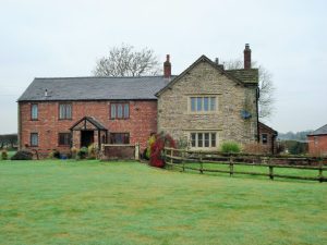
  Again I took the easy drier tarmac option, walking up Huntington Hall Lane past several expensively converted houses and barns. After a steep section, Huntington Hall itself appeared on the right, a 17century house which has had a lot of money spent on it in recent years. At the road corner I was back into the fields with views back to the Ribble Valley, I meant to say this was a rare, sunny, dry day. Cresting a hill Intack Farm came into view, again a place spending lots of money with a horse arena right across the footpath but the diversion was no problem and well signed – but is it legal? A quick peep into Crowshaw Quarry showed it to be remarkably dry, could be bouldering here later this week. Crossing the road the main forest track was taken eventually leading up to the trig point on Longridge Fell. Chipping Vale and the Bowland Hills were fairly clear but that was not really today’s objective.

Huntingdon Hall.

Longridge Fell Trig Point.

when they were up, they were up


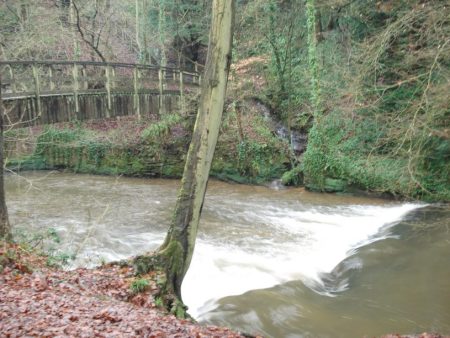
I came down by the track to Lennox Farm near where the Duddel Brook probably starts life.  A lane took me past Goodshaw Farm where the new lambs were being tended, the farmer told me he had 600 sheep to lamb this year and was concerned about the wet fields he was placing them into. Below the farm was an old barn, Smith Bottom, which on close inspection revealed two perfectly shaped cruck frames thus giving a clue to its medieval age. Down steeply through beech woods overgrown with rhododendrons to a bridge over our brook. This lane leads up to the highly secretive Dutton Manor in its cloak of trees.

A young Duddel Brook.

Smith Bottom cruck barn.

Trees hiding Dutton Manor.

Across the next road was Duddel Farm on its exposed hill. The farmer was feeding cattle in the barns and bemoaning the wet conditions, but despite that remained cheerful and chatty – we had many mutual friends and interests. He was right about the conditions as the next few fields leading back to Ribchester were almost afloat and the mud slowly crept above my knees.


I don’t normally take selfies.

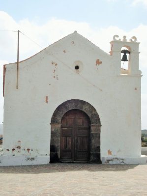
I was keen to reach the last two listed buildings at Stydd. First was St. Saviours a simple C12 chapel. Its plane interior has a flagged floor with ancient gravestones, a stone coffin and wooden pulpit and rails. Very evocative. Further down the lane is Stydd Almshouse built in 1728 to house the poorest parishioners. It is an architectural gem with its central staircase and diminutive size.

St. Saviours.

So back to where I started.

when they were down, they were down


I would like the challenge of an entire ascent of Duddel Brook – obviously in dry summer conditions and with a good degree of so called trespassing. Watch this space.

THE GARDEN IN FEBRUARY.

I must say that it was a slow start to the month with cold weather holding things up, only by the middle of the month did the temperature reach double figures and then came the wind. Even this morning we had a light snow shower. Normally I’m walking or climbing abroad this month but due to procrastinating I’m still suffering the British weather – I have however make good progress with pruning and shredding, neglected lately, so a large area of the borders now has a decent mulch. Accompanying me has been the sound of birdsong – it becomes louder as the month progresses, reminding me to provide some more nesting boxes.  All around in Longridge the fields are being eaten up with new developments, now that planning control has become meaningless, so I’m glad I have my own bit of countryside no matter how small.

The usual bulbs have pushed through and started flowering – snowdrops, crocuses, narcissi, scilla and anemone blanda – Featured ImageA few early herbaceous plants are flowering – a primula variety,   bergenia and pulmonaria officinalis. I have a young prunus ‘Autumnalis Rosea’ which struggles to show a few blossoms, I hope it will improve with age.This exercise of showing a month by month diary of my garden is beneficial in that it is highlighting gaps which I hope to fill. I notice my yellow witch hazel [Hamamelis] has disappeared and needs replacing. Within the last couple of days my pieris japonicas are just coming into flower – the aptly named ‘lily-of-the-valley shrub’.What will March have to offer?

BROCKHALL – OLD AND NEW.

Last week I attended the annual Chris Mayo Memorial Lecture hosted by our Bowland Pennine MRT, for whom Chris had been a doctor; always a sad occasion for me. I worked with Chris and he was a good friend. At the end of January 1993 I did a long walk in the Bowland Hills with Chris as part of my preparation for climbing Mount Kenya and Mount Kilimanjaro in the next month. Whilst I was abroad, and totally unknown to me, 45year old Chris, his 15yr old son Matthew, both from Longridge, and his 40 yr old brother from Edinburgh were killed in a tragic accident in Coire an Lochan in the Cairngorms. Long shall we remember them.
I am worn out from lots of tree felling and pruning in the garden and too many sessions at the climbing walls, its too wet and wild for anything else. So I needed a short relaxing walk at the weekend. Deciding to stay low and sheltered Mike and I headed for Old Langho in the Ribble Valley to explore the area around Brockhall Village. We parked next to the 16th century St. Leonard’s Church.This little sandstone chapel built  c1557 with stones coming from the recently dissolved Whalley Abbey, on the outside are several carved features from the abbey. We were lucky that the church was open, it no longer hosts services but is maintained by the charitable Churches Conservation Trust, so were able to investigate the inside features. Walking past the entrance to Brockhall Village, more of this later, we crossed fields outside Hacking Wood to reach the lane leading to Hacking Hall a grade1 listed early 17th century property. We had distant views of the massive hall with its mullioned windows and prominent garderobe. Closer at hand was Hacking Barn an interesting early Cruck  structure. The exterior has been much modified but the interior cruck trusses are impressive, the agricultural surrounds are a mess.

St.Leonards.

St.Leonard’s.

Hacking Hall.

Hacking Hall.

Cruck barn.

Cruck barn.

We next went down to the River Ribble just where the Calder joins from the south. The path downstream was washed away in parts and even today a large volume of water was charging down to Preston. A couple of canoeists were thoroughly enjoying their rapid transit. It was near here that there was a historic 17thcentury ferry and I believe an old wooden boat was in Clitheroe Museum. The house across the river was apparently occupied by the ferryman up to the 1950s.

Ribble/Calder confluence.

Ribble/Calder confluence.

Hacking Boat House, Kemple end behind.

Hacking Boat House, Kemple End behind.

At the end of Brockhall Wood, above the turbulent water of Jumbles Rocks,  we turned ‘inland’ towards the farm and former site of Brockhall Hospital. From 1904 to 1992 this functioned as one of Europe’s largest mental institutions. On its closure [care in the community!] a property developer Gerald Hitman bought the lease and developed a gated village of 400 properties. Blackburn Rovers have their extensive training grounds here, Mr Hitman also built his own contemporary home in extensive gardens, The Old Zoo. We skirted around the youth football fields and at the first road walked up into the village. On our left was the well secured Old Zoo but we spotted a lake, a few sculptures and a beech hedge maze, it would be fascinating to look around the grounds but I don’t know who now owns the property. The streets wandered through a variety of properties, a few adapted from the hospital buildings, many newish apartments and a scattering of architect designed detached mansions. There didn’t seem to be much soul to the village, no obvious shop or pub, commuting hell or heaven? On the way out through the permanently manned barriers, to keep out the riff raff, we passed an upmarket restaurant next to the modern Rover’s training facilities.

How times have changed here.

Hospital conversion.

Hospital conversion.

Hospital cottage.

Hospital cottage.

More upmarket.

More upmarket.

Oh! for a peek.

Oh! for a peek.

Rusty Rover.

Rusty Rover.

SIMON’S SEAT.

Bolton Abbey Estate riverside car park Tuesday 10am.

£8 please.

Eight?!

Yes it’s half term. But if you had come last week it would have been £4.

It has been in the news this week about airport carparks doubling their charges for school holidays so this is just another example of greedy businesses taking advantage of families. Rip off Briton.

The ‘pieman’ and I set off on today’s walk in a grumpy mood. We had chosen today to climb Simon’s Seat as there was sunshine forecast. Way back this was a regular winter walk for us, then we would extend the route to include the moors above Appletreewick [an interesting name] and Trollers Gill. A straightforward 9mile circuit was planned for today. The paths seemed to have changed now that the land is open access, I seem to remember sneaking in to some of these areas. At one time we also had a major offensive on the climbing routes on the summit rocks of Simon’s Seat – an atmospheric place to be on a summer’s evening. Stand out routes were Arete Direct VS and Turret Crack HVS. See later photos of crag.

The path into the estate passed by some ancient oak trees which must have been several centuries old. The Valley of Desolation was entered and the stream and woods followed upwards – the name derives from a storm in 1826 when most of the vegetation was destroyed but not the oaks obviously. A hidden waterfall was glimpsed through the trees. Once onto the open moor a cold wind kept us on the move. All the surrounding fells had rocky outcrops but we were heading for the highest group of gritstone, 485m, Simon’s Seat itself. The land rover track passed the shooters lunch stone. Scrambling up the summit boulders was tricky with slippy snow scattered on the rocks, it was still winter up here. Goback called the grouse. dsc05552

Below the crag we found a convenient lunch stone of our own, out of the wind, with views over to Perceval Hall and beyond. Classic Dales scenery. Reminisces of shared past trips kept us humoured, the Pyrenees, Greece, Turkey, Dolomites, France, La Gomera, Spain. Above we could trace routes on the rocks. We have been lucky.

Our lunchstone.

Our lunchstone.

The classic arete on the left of the crag.

A paved track cum water course took us steeply down into the valley where we joined the Dales Way, another old favourite. We now met people strolling the river bank commenting on the lovely weather – no idea what it was like up on the tops. We kept to the left bank path on the Wharfe which proved ‘undulating’. Good views down to the deadly Strid though.  https://www.youtube.com/watch?v=mCSUmwP02T8

The car park was full of £8 vehicles when we arrived back at the busy Pavilion. Coffee at the pieman’s was the most economical option before driving home.

A BLEASDALE BLAST.

Bleasdale.

Bleasdale.

The forecast was dire – strong easterlies and minimal temperatures.

Enjoying a Sunday lie in listening to the radio I was disturbed by a phone call at about 10am from Mike wondering if I fancied a walk in the prevailing conditions. He had cancelled sailing in Yorkshire [even worse weather – not suitable for rigging up]. Glad of the prompt I suggested a couple of venues and arranged to pick him up at 11am. Quick breakfast.

We plumped for Bleasdale – lowish lying and good tracks. I’ve done this walk many times in all seasons – ie.  But something new always crops up.

The wind was blowing at 30mph when we left the car but we were sheltered by that magnificent beech hedge along the road. Turning right into the estate road at the desirable small lodge views opened up of the Bleasdale circle of fells. We walked through the estate houses and workshops and headed straight into the wind. As you go into a shelter band of trees there is a tall arched bridge across a small stream, I’ve never taken much notice of this before but today clambered down the bank for a better view. On the parapet downstream is a crest with the stonemasons’ tools highlighted but no date or name.On the open stretch of track the wind was fierce blowing sleet into our faces, we didn’t hang about. The hills disappeared into the cloud and we were glad we weren’t up there. We were passed by a girl on an electric mountain bike with the widest tyres I’ve seen on a cycle. Battered by the wind we passed the track to Bleasdale Circle.

Mystic Bleasdale circle.

Mystic Bleasdale circle.

On to the isolated church and school. The wind turbine was hurtling round and no doubt providing electricity to the grid via the community centre. Things have changed here since my last visit – the well-insulated parish hall has connected to the turbine and also installed an ecological wood pellet burning boiler. Quite a step forward for this small community.

All is not necessarily rural idyll in this area –

After 4.5 miles we were glad to be back at the car and home for soup and rugby on TV.

A PRESTON TEN PARKS WALK.

Preston was at the forefront of providing Municipal Parks in the 19th century with forward-thinking from its Elders, Several of the developments were enhanced by using local unemployed cotton workers during the Cotton Famine due to the American Civil War in the 1860s.  In Haslam Park last year I remember noticing a forlorn blaze mark denoting a Preston Seven Parks Walk and I made a mental note for a future winter walk. The forecast was good for Saturday, most of my walking activities are governed by the forecast these days, so Friday night I did some Internet research with little success. The seven parks were mentioned but nowhere was there any detailed route information so out came the 1:25,000. The first thing I noted was that there were nine obvious parks in Preston, although one, Farringdon Park, was, in fact, a cemetery, so my objective changed and I wanted to also include Fishwick Bottoms, a green area, arguably a tenth.

A clockwise route was devised with hopefully as little street walking as possible taking me to parts of the city I had never explored. Some areas have a bad reputation, rightly or wrongly and I wanted to complete those in the morning rather than potentially in the dusk.

Deepdale Sainsbury’s was a good parking spot and after a heavy shower I set off at about 10am down the delivery bay of the supermarket – it was going to be one of those walks. Gates took me into Brookfield Linear Park and a path followed a little stream, Eaves Brook, through a narrow green strip in Holme Slack. As a result of being so close to housing the amount of rubbish and burnt out debris was disappointing.

Strange fruit.

Strange fruit.

Familiar roads, Cromwell and Ribbleton, were crossed and a bit of scrambling took me into Grange Park. This was much more extensive and at the far end next to the motorway were remains of formal gardens which were better maintained. The park was developed in the grounds of Ribbleton Hall whose foundations have been restored.

From the motorway bridge, I could have followed tracks to Brockholes nature reserve and then the Guild Wheel to the central parks, but I wanted to visit the next three hereabouts. So turning away from the noisy motorway a stroll down the estate took me to Farringdon Park which is the city’s cemetery. Paths weaved between the gravestones, these paths apparently being laid out as a butterfly only visible from above. Rows and rows of sombre ornate Victorian headstones lined the path,  more arresting was an area given over to children’s graves. These were colourful with mementoes of the lost childhoods but very distressing to witness. There are other areas of this park I would like to explore including a Muslim and Jewish burial areas. I emerged onto the road adjacent to Waverley Park which is mainly recreational with football pitches, bowls and children playgrounds. Crossing over to the Fishwick estate I found a path dropping to a large open recreational field in Fishwick Bottoms and then skirting the notorious Callon estate following a lane down again to join the Guild Wheel to Walton Bridge. A better way would have been to enter the Fishwick Nature Reserve linking to the same place, but I was unaware of its existence – next time.

Fishwick fields - not a drug runner in sight.

Fishwick fields – not a drug runner in sight.

The familiar riverside track led into Avenham Park with its open aspect and popular café …

Avenham Park

Avenham Park

then Miller Park, more ornate with terracing, statue, bandstand and fountain. The large brick building towering over Miller Park was formerly the Midland Hotel serving Preston railway station and now used as council offices. Both these parks have had a lot of money spent on them in the last few years to bring them back to their former glory and in today’s sunshine were extremely popular.

Miller Park - ignore the ugly council block top left.

Miller Park – ignore the ugly council block top left.

To reach my next objective I continued on The Guild Wheel along the river into Preston docks, now a marina, stopping off at the welcome café. A short section of road walking, and I was in  Ashton Park again a more open space surrounding the old hall. The  playground seemed to have an entertaining variety of equipment for young and old. Crossing the busy Blackpool Road a short street gave access under the railway and Tom Benson Way [the ultramarathon walker]  into Haslam Park. The pasture land for Haslam Park was the gift of Mary, daughter of John Haslam, a local cotton mill owner, the park opened in 1910. As I entered from the south there were acres of parkland with Tulketh Mill in the background, a reminder of the cotton trade which brought so much prosperity to the city and helped establish the parks I’m visiting. The Savick Brook runs through the park which also has a lake and large recreational spaces. The water for the lake cascades down an artificial grotto from the Lancaster Canal above.

Haslam Park with the iconic Tulketh Cotton Mill in the background.

Haslam Park with the iconic Tulketh Cotton Mill in the background.

The towpath of the canal helped me cross Preston towards my last park. Chatting to a man tending his canal side garden he alerted me to the presence of a Kingfisher which I later luckily saw rapidly disappearing under Blackpool Road. A few back to back streets, and I was entering through the prominent gates into Moor Park which has a long and interesting history detailed here and here. [The observatory has recently been upgraded by the university] Today the sunshine had brought lots of people into the park. I walked around the lake and past Deepdale Stadium, Preston were playing away today, down Tom Finney Way and into Flintoff Way and my car. The latter two along with Tom Benson complete the trio of Preston’s sporting heroes.

This 12-mile circuit of these parks shows to varying degrees how green spaces enhance the city providing recreational facilities for all as well as suitable animal and plant habitats. My only fear is what will be their condition in a few more years of our cash-starved council? I am sure they will not be developing this circuit as a Preston Ten Parks Walk.

THE GARDEN IN JANUARY.

I have been meaning to follow my garden through the seasons for awhile – January is a good place to start. Due to our topsy-turvy climate this year there are no pretty pictures of fragile blossoms pushing through the snow, though a spell of icy weather has retarded some plants. 

The photo above shows a rather bare garden with my progress in cutting down a 50year old Blue Spruce that lost all its needles a couple of years ago and unfortunately shows no sign of recovery. The best wood will fuel my stove but I’ve decided to shred the brash to use as garden mulch.

January is a difficult month for flowers and I’ve relied on hardy shrubs to bulk up this post. From the start of the year the Mahonia, Jasmine and Virburnum have been in constant bloom. Slowly the Hellebores have come into flower and that’s about it really but I’m hoping things will get going next month. Maybe I should plan ahead for next January with more plantings.

Mahonia Charity

Mahonia Charity

Jasmin nudiflorum.

Jasmin nudiflorum.


Viburnum Bodnatense

Viburnum Bodnantense.   

Helleborus argutifolius. Corsican Hellebore.

Helleborus argutifolius. Corsican Hellebore.

Helleborus sternii

Helleborus sternii

Helleborus purpurascens.

Helleborus purpurascens.                                                     

Helleborus niger.

Helleborus niger, Christmas Rose.

I’ve just come in from the garden as the sun sets and starlings congregate in a nearby tree for possibly some murmuration later.

BOLLIN VALLEY WAY. Into the Mersey.

Ashley to Partington.

Arrived back in Ashley courtesy of my son on his way to work. A long surfaced bridleway had me off to a good start as the sun rose to a beautiful day. I was not expecting too much from this stretch so the blue sky was a bonus. Again the few walkers I met were dog walkers. A stretch next to the M56 was distinctly noisy and poorly waymarked, the River Bollin looking a little worse for wear. Things improved as I entered Dunham Massey estate, the path on a flood bank as the river meandered through the fields. There was a perfect example of an Ox Bow lake. The brick walls of the hall gardens up to my right hid any views and I didn’t have the inclination to divert into the grounds, magnificent as I know them to be from previous visits. Crossing the river at Bollington Corn Mill I wandered through the hamlet of Little Bollington too early for the Swan with Two Nicks to be open. A cobbled lane led to the Bridgewater Canal and then fields took me across to the village of Dunham Woodhouses. Here to stay nearer to the river in its last few miles I diverted onto the Trans Pennine Trail, an old railway on this stretch, and walked quickly to Heatley where the Bollin disappears across fields in to the Mersey Ship Canal. I followed lanes to the canal and then a pleasant path into Partington and a bus back to Piccadilly. A great walk improved by the start at the source.

Last view of the River Bollin as it disappears to the Mersey.

Last view of the River Bollin as it disappears to the Mersey.

The Mersey Ship Canal.

The Mersey Ship Canal.


BOLLIN VALLEY WAY. The middle stretch.

Prestbury to Ashley/Hale.

Rush hour.

Rush hour.

Having braved the morning rush hour at Piccadilly I was back at Prestbury before 9am. Spent the first half hour adjacent to the largest sewerage plant I have ever seen. All was quiet, I really mean quiet after all that commuter bit, as I rejoined the ‘way’ – I saw nobody till Wilmslow. That was apart from the lady with a plum in her mouth who instructed me how to open a difficult gate in her garden obviously designed to deter walkers. Nice house by the way.

Recent floods have eroded the banks of the river and attempts to restore the channel have been made – why not let nature take its course. There was a perfect example of an oxbow lake further on today.

Arriving in Wilmslow I went up into town to find a coffee, the first place was a Waitrose store which I thought would host a cafe but only offered an expensive machine which sufficed. Refreshed I returned to the river and a popular walk along it. Dogs and elegant ladies. I fell into step with one of the latter with her equally elegant terrier Spikey – he mistook me initially for a postman and yapped loudly. Having made friends I was escorted through the grounds of Quarry Bank Mill and Styal Estate – fascinating and worthy of a return visit when the gardens are open. Thanks to my anonymous guide. Strangely the official Bollin Valley Way doesn’t use this section of river bank but the North Cheshire Way does.

Quarry Bank Mill.

Quarry Bank Mill.

Styal Village.

Styal Village.

Quarry Bank Gardens.

Quarry Bank Gardens.

I returned to the river and had a roller coaster trail  – at one point alongside it and minutes later up steep steps high above. This continued for some time until I realised I was below one of Manchester Airport’s runways and had to disappear into  a tunnel under it. Emerging the other side I climbed up to a view point to be told by an ‘observer’ that an A380 flight was taking off – it was dramatic when it appeared – Massive. Planes continued taking off every couple of minutes as I walked on through reclaimed wetlands and woodlands on the airport perimeter. I have to say they know how to make mud in Cheshire. Strangely I found walking in the vicinity of the M56 more noise polluted than the airport environment. Speeding up to catch a 4pm train I made some simple navigation errors around Hale golf club and the back tracking lost me valuable time so as I walked towards Ashley the train disappeared. Luckily the Greyhound pub provided a warm welcome for the hour wait for the next train and reflect on a hugely enjoyable 14miles.


BOLLIN VALLEY WAY. Out of the forest.

Source to Prestbury.

Baby sitting duties in Manchester brought me down this way so I took the opportunity of exploring a new area. A dark early morning start from home on the bus and then trains transported me to Cheshire. When I researched this route on the LDWA site I was surprised to see it started in Macclesfield town, what about the true source of the River Bollin up in Macclesfield Forest? The helpful taxi driver dropped me off in Standing Stones car park high in the Forest. In thick mist I had to take a compass bearing to find the right path out. Amazingly within 50m I found a stream gurgling out of the hillside, was this the Bollin? I decided it was and began my walk down it. From my map I expected to be following lanes for a few miles but to my delight there were new paths everywhere and I was lucky that some took me through the forest in the right direction. The reservoir walks were popular with dog walkers,  above would be Teg’s Nose but no chance of a view today. Dropping into a a hidden valley the Bollin Brook picked up pace. Here I came across Gritstone Trail signs, a walk I enjoyed many years ago. A little further and I walked below the canal used by the Cheshire Ring walk, more recently completed.

It was already lunchtime when I walked into Langley, the interesting looking pub was closed so a park bench sufficed. A sign celebrated a William Smith who founded, in 1826, Langley Mill [now derelict] which became the largest silk printing works in the world. There are many humble cottages around presumably mill workers’ dwellings originally. quite a contrast to Langley Hall down the road. The were other signs of past industry – dsc05115

The Bollin has an unhappy journey through the industrial part of Macclesfield, famous for its silk mills. It emerges the other side in a country park which gives easy riverside walking, mainly used by dog walkers, to the village of Prestbury. Along here I picked up the official Bollin Valley Way markers.

As dusk approached I caught my train up to Manchester in time for the rush hour crush on the Metro tram.


BEACON FELL CIRCUIT.

It was one of those out of body experiences – I was 11years and cycling as fast as I could around the Teesdale lanes getting strong for some time trialing; then I was in my teens touring various parts of Britain with my mates; now I’m 30 and exploring the Trough of Bowland and further afield doing 100 mile days; next I’m 50 and cycling across Europe on endless adventures. Now I’m off my bike and having to walk up a steepish hill onto Beacon Fell. Bugger.

Today’s circuit from home is about the same distance as the Preston Guild Wheel which I’ve been using recently but with HILLS – over a 1000ft of ascent. Your are on your own here.Still the roads are quiet, the sun is shining and I’m wrapped up against the freezing temperatures.

Beacon Fell is a local landmark and popular with strollers and families. It is one of my regular haunts usually walking as previous posts detail. I had forgotten how impregnable it was on a bike. Still the cafe is open all year. Despite the icy roads it was mainly fast downhill from here on the long way round to Chipping under the Fairsnape Fells. There were a few more hills I’d forgotten about!

and then I’m sprinting to the finish on the Champs-Élysées.

***

As an aside I passed several laneside garages long since abandoned, they were a feature of the countryside 50 years ago. They were never open when you needed petrol  on a Sunday afternoon but their skilled mechanics kept the locals cars and tractors on the road. No plug in diagnostics in those days.


TAME VALLEY WAY. 2 Stalybridge to Stockport.

The cobbled steps down into Stalybridge were icy, I crossed the River Tame and continued on the Huddersfield Canal. There is something about canals as they pass through towns, graffiti and rubbish unfortunately abound and here was no exception. The canal has been restored, no doubt at great expense, as part of a millennium project and should be a great asset to the town but sadly it provides a haven for ‘ne’er-do-wells’. Enough said, but we have moved on from…

Dirty Old Town – YouTube

The river and canal are in close proximity, but the route favours the towpath just because of its existence. Crossing from one to the other I used The Alma road bridge constructed in the same year, 1854, as the first major battle of the Crimea War. On the outskirts the usual light industry flourishes and there always seems to be a background hum from the units reminiscent of the sound track from some old Sci Fi movie. Relief came at Portland Basin where the area has been gentrified with living accommodations  and boat trips. Here is a junction with the Ashton Canal heading into Manchester and the Peak Forest Canal coming from Derbyshire – what a network. I had a feeling of deja vu and it was only sitting down with the map I realised I was on The Cheshire Ring which I walked last year Rivers lose there character hemmed in and stagnating through towns and industry  but when I next joined the Tame it was in pastoral green fields. Amazingly these have been created from  what was the largest refuse tip in the area! All that tranquility was soon disturbed by  passing under the thunderous M67 whose six lane highway has replaced a two lane main road. What will we need in another 25 years?  The remaining few miles into Stockport were all surprisingly rural in country parks and close to the River Tame. The problem was with so many well trodden paths and poor signage one had to sometimes make an educated guess as to the route, keeping close to the river seemed to be a good idea. At the end of all these fields I emerged into Reddish Vale where the world and his dogs were congregating, there was a nearby carpark. The ducks were showing their skills at walking on water. A dismantled railway  gave fast walking, I had a train time in sight, before dropping to the River Tame for its finale. Under the M60, as it bypasses Stockport, one would never normally know that the Tame joins the Goyt at the end of its journey down from the Pennines. Having congratulated myself on reaching this point in good time I was dismayed by the length of traffic dodging streets up to the station to catch that train back to Preston. Another two day route completed in perfect winter conditions, apart from the dazzling low sun, and a good start to 2017.