Tag Archives: Bowland

CALDER VALE FROM BLEASDALE.

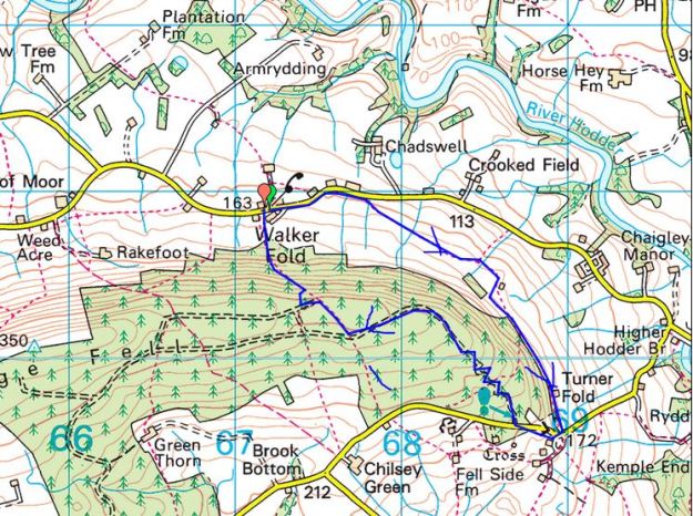
Thursday  10th December.      6.5 miles.          Calder Vale.


My last visit to Calder Vale was in February just before the lockdowns commenced. Almost a whole year gone when I have been restricted by one Covid measure or another, its grim up North. That day I walked through the yard of Cobble Hey who run a popular farm café,  they were due to open the next day for the season. Speaking to a girl there today they have  been barely able to function at all, the customers just disappeared.  She was hoping for better things next year.

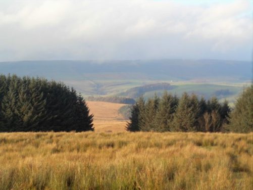
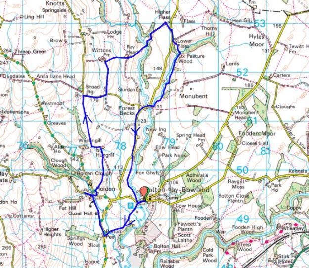
The route I had planned for today had me approaching the Calder from above using paths untravelled. I parked at the summit of Stang Yule, the road linking my area to Dolphinholme across the edge of the Bleasdale Hills. All was grey all around me. The distant Fylde Coast a blur and the surrounding fell tops uninviting.

At the first farm I came to, Rough Moor, a couple were planting a new hawthorn hedge, well over 600 plants, I admired their enthusiasm and the renovated farm and barns will become desirable country living advertised in Lancashire Life. At least they had provided good stiles and waymarking around the property. As you walk down the hillside there is no clue that below is the once thriving mill village. I passed a few more smart houses before walking through the grounds of St. John’s Church and adjoining school. The church and school were built in this rather isolated position as they served both the Calder Vale and Oakenclough communities. A path leads down through the woods into Calder Vale, I wonder how many children still walk this way to school each day.

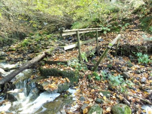
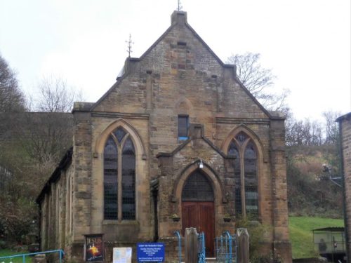
There is plenty to see in the village which always seems busy because of the working mill in the centre, There are remnants of the water power from the Calder, workers’ cottages, Methodist Chapel, manager’s house and the large Lappet Mill itself. The post office and village shop have closed and there is no sign of the Temperance Hotel. I left your Christmas presents under the tree.

I departed the village by a stile and age-old stone steps onto a lane linking to farms on the fell above. They all had a sad and unkempt look about them on this grey day.

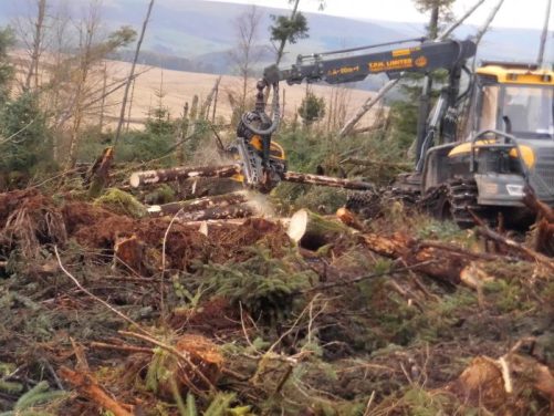
Lots of wet fields led me to Cobble Hey which as I said was deserted and I certainly didn’t expect to meet this Juggernaut on a narrow farm lane.

The paths through the next few fields were untrodden even this year when the world and his dog have been out exercising. My legs became more and more splattered with mud and I don’t know what else. On reaching Delph Lane I could have easily walked up it to my car but something made me obstinately carry on with my planned route. The footpath was sensibly diverted around the next  farm, High Moor, but I was apprehensive as I approached Broadgate, a typical sprawling shambles of a farm – more industrial than agricultural. My GPS proved essential to navigate through. The continuing lane was a  mess from timber extraction.

I knew the next field to be muddier than most from a visit a few years back with my old mate Mel, sadly deceased this year. We had set off on a simple walk in trainers on the estate roads around Bleasdale when I suddenly spotted a footpath leaving the dry lanes across this very field. I cannot repeat his comments as we slowly sank into the almost knee-high mud but kept going nonetheless and laughed about later in the pub. That’s what friends are for. Today I was heading in the opposite direction towards the big house, Bleasdale Tower which looks austere at the best of times – I often imagine a face at that upper window, Rochester and Jane Eyre below. Today I just get the face of a friendly sheep in the paddock below.

I’ve touched on the interesting history of the Bleasdale Estate in previous posts.

Today as the afternoon wore on I had an easy walk back up the estate road to my car at the high spot. It was still grey all around but I’d perversely enjoyed the afternoon though I doubt few others would have.

*****

I’ve just come back from the supermarket where outside a class of junior children were singing carols. I was emotional today, and they brought tears to my eyes which is always difficult when wearing a mask.

*****


WINTER SUN.

Sunday.   6thDecmber.  7.5 miles.   Longridge.

 I’m usually still in my dressing gown at 10am, drinking my second or third coffee. That’s how life is at the moment what with lockdowns, third tiers, grieving days and short winter days. My cleaner is still not coming to my house, in fact nobody has really been in nine months, but I can’t be bothered with the ‘hoover’ today. It’s Sunday.

I should be writing Xmas cards and words of encouragement to my distant friends but I can’t find my address book. I’m sure I had it yesterday.

It’s now 12noon and I grab a bite to eat. There is little sun but no wind or rain. I can’t face muddy fields or driving anywhere, so I opt to do my short Longridge Fell Walk on roads for some exercise. We have walked this route many times, I apologise.

I don’t meet as many people out as expected, maybe they are Xmas shopping whilst the stores are open. A few cyclists pass by, struggling on the hills, as well as puffing joggers. I just march on at a steady pace stopping now and then to take a photo, and I don’t take many of those, being so familiar with the scenery.

The Newdrop Inn is soon reached, now sadly closed for ever and then up the long drag to the high point of the walk. I think about past sunny days bouldering with friends in a couple of quarries up here, what a wonderful way to while away a few hours in utmost concentration on the rock. On a gate post is a simple arrangement, a memorial to whom?

I walk down the road alongside the golf course in contrast to the other day when we just followed the fairways. A few lost golf balls were picked out of the verge as swag. Again in contrast to before the golf car park was full now playing is allowed. Some wayside gorse brings a little colour and there is a dusting of snow on Fairsnape if you look carefully.

Once home I had another go at getting rid of the leaves on the lawn. Now where is that address book?

THE FYLDE AROUND GREAT ECCLESTON.

Wednesday 2nd December.  6.5 miles.  Great Eccleston.

Great Eccleston is a village in the Fylde, that often gloomy and flat area of Lancashire not known for its walking. It was mentioned in the Domesday Book so has ancestry. It is known locally for its traditional shops, good pubs, a weekly market and its annual agricultural show which incorporates tractor pulling competitions, a niche motor sport. I parked up at noon on a sunny day, one needs the bright sun on these featureless landscapes. There was a bit of a market in the main street. I noticed one of the pubs has closed. There is an old pinfold down the street.

I left by Leckonby House, named after a wealthy local who bankrupted himself and ended up In Lancaster Prison. There was a C18th dovecote strangely isolated in the next field.

The St. Annes church at Copp was a prominent landmark up the road. It was established here in 1723 halfway between Gt. Eccleston and Elswick as a chapel of ease for St. Michaels. Nearby is a local primary school and opposite the old schoolhouse. It seems odd that the school is so isolated but I suppose it followed the church originally.

Elswick down the road is another small village on the road to Blackpool famous for its ice cream parlour. Also tucked next to the United Reformed church is an old chapel with a date stone of 1671 when this area was a centre for Nonconformity. The chapel is rather plain and has a house built onto it, it is now used as a hall for the adjacent church.

It was time to take to the boggy fields just as a hail storm blew through giving rainbows over the distant Bowland Fells.

Another stretch of lanes led towards drainage and flood defences. Here I got tangled up in barbed wire fences obstructing the right of way, later contacting the local authority they already knew of the problem. Surely the fencing contractors should be made aware of the need for stiles in the appropriate places. At last, I was on the embankment and following the Wyre downstream, a popular route for dog walkers. Walking around the loop was fast and easy which was needed as the sun was beginning to set. I had time to look at the Cartford toll bridge and the adjacent pub which has been modernised since I used to drink here 40 years ago. More rainbows appeared with the passing showers.

Being back here reminded me of a rather disastrous day walking the start of the Wyre Way.

The lights were on when I arrived back in Great Eccleston’s marketplace.

*****

THE LOWER RIVER BROCK.

Friday 27th November.  7 miles.  Inglewhite.

I have done quite a bit of walking on the River Brock recently, in fact most of it from the source to Brock Bottom. Today we walk onwards towards the Wyre a less frequented destination,  I was expecting a lot of boggy fields with awkward stiles and yes that’s what we found.

Leaving the village green of Inglewhite with its market cross we were amazed at the development spreading out into the surrounding fields. It all looked rather fine country living but where will it end. Anyhow, we splodged on to escape on to a minor road just ahead of a herd of inquisitive, threatening  bullocks.

We could relax and chat for the next mile or so until we dropped on an old way to the River Brock. There was a footbridge crossing into the Brock Bottom Mill site, I’ve written about this before. Today we walked on past the mill sites and through fields to Walmsley Bridge.

Then more fields with the River Brock cascading down hidden falls until we seemed to be in someone’s vast garden alongside the river with the no doubt grand house hidden to our left, Brock Side. It is great walking with Mike, an architect, because he seems to have been involved one way or another in the past with many of these rural redevelopments. His, no doubt up to the best standards.

After a bridge and weir the Brock has been tamed along the next stretch by concrete walls. A private road runs alongside to a dead end and a footbridge. On the left, half in someone’s garden, is the remains of a water powered mill, Matshead paper mill. Over the footbridge a lane follows the river downstream under the motorway, railway and canal to disappear without rights of way into the Wyre. No longer the bubbly Brock from Bleasdale.  There is another weir by the road and the site of the old Brock Station, closed in 1939 to passengers and 1954 to freight, now utilised as a nature reserve.


Off to join the Wyre.

Back to the footbridge we were supposed to turn into a yard and follow a path between houses and barns. All I could see was a gate into a ‘private’ garden but Mike spotted someone and asked where the footpath went and was somewhat begrudgingly told – through the gate and past the garage. I doubt few will brave this way. We emerged from a series of gates and gardens back into the fields where all was rural again with open views to the Bleasdale Fells and Beacon Fell.

These fields lead us to Bilsborrow Hall Farm, the hall itself is well hidden in woods across the way. We trusted to our directional sense to find a way through what was more of an industrial site than a farm.

The next short stretch of road was scattered with expensive looking residences, some more pleasing to the eye than others.

More awkward stiles and soggy fields led us back to Inglewhite and the Green Man, closed of course.


I have wonderful memories of Doreen playing the piano, despite her worsening Alzheimer’s, at lunchtime in August 2019.


*****

AROUND MIDDLE KNOLL.

                                                                                  MIDDLE KNOLL.

Thursday  26th November.    7.75 miles.     Dunsop Bridge.

I thought I would incorporate some  possible fish jumping into today’s walk, as I had failed on the Hodder awhile back, so I chose to walk up the waterboard road from Dunsop Bridge. First problem was the road through Whitewell was closed diverting me over via Cow Ark and backtracking  from Newton. I was still early enough to get a free parking place. The mist was just rising as I started up the valley. This is a familiar track for me but I always enjoy the view up the valley with Middle Knoll centrestage, even though today he was slow to appear… I stopped at the fish ladders on the River Dunsop just below where the Brennand and Whitendale converge. No luck, no fish, so I carried on thinking I could spend more time later in the day. You are soon into the Brennand Valley with the farm down below and views into deepest Bowland. It is awhile since I’ve been on this lower track, last time I was here with JD we did a direct ascent up Middle Knoll to satisfy my curiosity of Blue Scar, which proved disappointing.

The Brennand Valley.

Looking back into Brennand.

My route up to the col between the two valleys was as wet as usual. Views back to Brennand Fells were replaced with a bird’s eye views down to Whitendale Farm. It was a steep descent.

Looking back into Brennand.

Wet going.

Whitendale Farm.

Looking back at the steep descent into Whitendale.

This is Duchy of Lancaster land owned by the Queen and yet United Utilities [NW water] seem to manage much of the land as a water catchment area. My way back down the Dunsop valley in fact follows a pipeline taking water to Blackburn. It is a good level track overlooking the valley and I make good progress. In the past I have cycled up the water board road and hidden my bike hereabouts before taking to foot up the rough Whitendale valley, a good tip for exploring deep into Bowland. Today I rest awhile at the river intakes where concrete steps control the waters. Still no sign of fish but it is always good to see the rural postie driving by.

The pipe.

Costy Clough.

Wot? No fish.

The sun comes back out and gives lovely low lighting in the valley. I’m soon back at the car and a Covid takeaway coffee from Puddleducks Café.  It looks like I’ve missed out on the fish going upstream this year but I’ve earmarked several possibilities for next season.

Did some of those pictures remind you of Scotland?

*****


GOING HIGH[ish] – FAIRSNAPE.

Sunday  22nd November.  7.5miles.   Fairsnape, Chipping.

A chance comment from Sir Hugh last week – “glad to see you going high, or highish” when I hadn’t really, up above the Hodder. Time to put things right with the highest fell close to me in Bowland, at 520 m, Fairsnape.  [Pendle Hill I climbed a few weeks ago is 557 m, Sir Hugh must have missed that one, but is now out of my self-imposed lockdown driving limit]

I pull in at a little parking spot on that lonely road heading into the hills above Chipping. This  used to my fell running circuit, up Saddle Side over to Fairsnape and down over Parlick. I decide today to do it in the opposite direction, something new. I play with my camera in panorama mode trying to catch the scene, the result is the header photo.

Walking down the lane I drop into Wolfen Mill, now a group of holiday lets. The Chipping Brook which powered the mill here continues down past several abandoned watermills above Chipping.

Chipping Brook.

Wolfen Mill pond.

As I follow the estate road a rainbow develops over the fells, more fiddling with my camera.

Wolfen Hall, now bypassed by the right of way, was once the old Manor House dating back from C13th. In those days it was said to be a lookout post for marauding wolves! It has been comprehensively rebuilt and the adjacent kennels are a noisy reminder of its present hunting credentials.

I reach Fell Foot and meet the crowds coming up the lane, I estimate well over 60 cars parked down there. Typical lockdown weekend.

As the majority stagger straight up and down the front face of Parlick I take the contouring path round the side but do make the effort to complete the climb to the summit. Everyone is enjoying the day, even the children, and glad to chat.

Around the rim I pace myself along the well-used track. There is nobody sat on Nick’s Chair today, most don’t even notice it.

As I arrive at the 510 m summit I’m trying to get a photo of the scene when along the ridge come three friends. We compare our routes and then pass on, they down with the crowds and I across the peat hags to reach the true summit.

Paddy’s Pole, shelter and trig point.

Visibility is good for this dodgy stretch where you can flounder into serious bog if not careful. I was the only one at the cairn but a man appeared from the delights of Fiensdale looking rather bedraggled.

The true 520 m summit.

On I went using the decent track eastwards and bump straight into Pete, a photographer friend who is compiling a new book on Bowland. He is laden down with long lensed expensive cameras and hasn’t come far. More catching up in these strange days when you don’t see your friends for months.

There are some well-used tracks down Saddle Fell, probably old sledge ways for gathering peat. I stray to look across at Burnslack Fell and down to the remote Burnslack ‘farmsteads’, this gives me the idea to extend my walk around the fell to visit this isolated spot.

Burnslack Fell.

Burnslack farms.

Burnslack Valley.

Burnslack Farm.

Pendle Hill and Longridge Fell.

As I wander back up the lane to my car hail showers blow in – winter’s coming.

*****

THE INFANT HODDER.

Thursday 19th November.  5 miles.    Cross of Greet Bridge.

I remember walking The Hodder Way 15 years ago to check the route description for an upcoming guide. We started on the watershed high on that lonely road from Slaidburn to Bentham. Next to the road is the base of the medieval Cross of Greet.  A large irregular block of sandstone with a flat top having a rectangular socket, once marking the boundary between Lancashire and Yorkshire. This road is a favourite with cyclists continuing over Tatham Fell and perhaps making the return over Clapham Common and Bowland Knotts. This morning the whole area looked appealing in the sunshine.

From up here the Hodder starts its journey and snakes down the valley.

Back at the Cross of Greet Bridge I parked up, the Hodder is already in full flow.  The bridge is strictly utilitarian. The path alongside the river was underwater, so I headed for higher ground. Rough going was to be expected, and the side streams became more and more difficult to cross. I had nagging doubts about whether it was wise to set off when there was so much water about. Everywhere was awash. I was pleased to arrive at the ford over Kearsden Beck dry footed, thanks to my new boots, but the water here was too deep and fast flowing, so I scouted upstream for another crossing finding one without too much difficulty and hopped across.

Spot the barn.

Unfordable ford.

A hop across.

Now back on dry land I was climbing uphill above Catlow farm to a solitary barn on the skyline, seen in one of the photos above.

Remote Catlow Farm.

Sinkhole marked on the map.

That barn.

Old cart.

Pendle portrait.

Bowland Knotts were beyond if I’d fancied an even rougher pathless walk, but I decided to traverse the hillside towards New House barn with Stocks Reservoir and Pendle ahead. I was now on the upper half of the Stocks Reservoir walk which I knew well. Up here above the Hodder I can see across the valley to Lamb Hill where I’m heading. Steeply down to the footbridge over the Hodder where I remember stepping stones, they would have been underwater today. The ruined farm of Collyholme is barely recognisable.

New House Barn.

Lamb Hill across the valley.

Collyholme.

The steep pull-up to the road has been paved in places which was a help in these boggy conditions. I could have just walked back along the road, but there is a footpath marked going up to Lamb Hill farm which I followed.  The farm has massive modern barns making the house virtually invisible.

Lamb Hill Farm.

Across the valley Bowland Knotts filled the scene. A footpath of sorts weaved through and on down the sodden fields. I came out onto the road just above the bridge but wanted to investigate some riverside sheep pens I’d noticed earlier. Climbing over a fence and going through dead bracken gave me a bird’s eye view of the extensive walled folds. These must have been used in the past when bringing the sheep off the fells and sorting them, I doubt they are in present use. The world has moved on even up here.

The road over the fells.

A short day but what a beautiful remote area.

*****

PONIES ON THE FELL.

Tuesday.  November 17th.  5 miles.  Longridge Fell.

What a gift for my ‘a new experience every walk during this lockdown’. Fell ponies welcomed Rod and I to the summit of Longridge Fell. I’ve never seen them up there before and I have no idea where they come from. Three healthy looking, sleek, black ponies. They were used to human presence and searched our pockets for food. It is not a good idea to feed ponies as I believe  they can become ill quickly.

We had arranged to meet on the fell road as we hadn’t seen each other for 6months. A little inventiveness had to be used to get parked amongst all the other lockdown ramblers. I warned Rod in advance to wear boots as everywhere off track is decidedly gloopy. Certainly on the last quarter of a mile from where we had left the forest road it was difficult to stay on solid ground.

The sun shone a little into the Vale of Chipping below us and the Bowland Hills looked – well just like they always look, majestic, if a little hazy. I steered a way through the woods along the ridge avoiding the worst of the mud and the fallen trees. We then made our way back on the solid ground of the main track and caught up with each other’s news, restricted as it is. Home in time for a late lunch before it rained. See you after Christmas Rod? Strange times.

*****

A HISTORY LESSON IN WYRESDALE.

National Library of Scotland.

Monday,   November 16th.    9miles.       Scorton/Dolphinholme.

The river Wyre takes a sinuous route between Scorton and Dolphinholme and you can see from the map many fishing lakes along the way. Years ago it would have been a different scene with leats, millraces, serving the numerous mills in the valley. My ‘guides’ for today live in the area and know an awful lot of relevant history. The last walk with Peter and Denise was a couple of winters ago when we followed and traced the Lancaster Canal from Preston to Kendal.

After driving 14 miles, within my 15mile limit, I meet up as the one other socially distanced person. We are all following the rules now, even Boris has to. Off we go along lanes close to the motorway passing the farm of a close friend, sadly departed 5 years ago, where my family of cats originated from. It is eerily deserted today.

My cats’ homeland.

We pick up the Wyre Way which seems to have changed since I walked it a few years ago. The footbridge over the motorway has been dismantled, apparently the path goes under now. The caravan site we walk through has expanded dramatically but of course nobody is allowed to stay at present. The big attraction is  the fishing lakes established from old gravel pits, stocked with carp, pike, bream, tench, roach and perch. They don’t have a sympathetic feel for a path. A better stretch alongside the Wyre brought us to a bridge that used to lead to Wyreside Hall. Further along is the old Coreless water mill with its restored wheel.

We come out into Lower Dolphinholme. Peter points out the old mill warehouse, now apartments. The road down to the bridge used to come to a ford and when it was built up the doors to the cottages became smaller and smaller. The mill manager’s and mill owner’s houses are prominent and there is a redundant gaslight on the corner. The large mill here was originally for worsted manufacture and was one of the first mills to have its own gas works to light the mill and village.  Apparently behind the private walls is evidence of the gas containers. Peter knew all about this but for you a good history is really worth consulting – https://historicengland.org.uk/listing/the-list/list-entry/1466557


Diminishing doors.

Mill owner’s House.


As we leave the village I’m taken on a slight detour to visit the flue and chimney up the hill. It was built as a dual structure one for the gas and one for the steam from the updated mill.

We were going up  Waggoners Lane an obvious reference to the mill’s transport and then into Tinkers Lane, another reference to the past. This led past Belvidere House with its unusual hexagonal attached tower. Up here we were on the edge of the Bowland Hills and sheep were the only animals in the fields, subsistence farming. We came to a crossroads at Street where the Roman Road from Ribchester to Galgate was supposed to have run.

Now back onto paths alongside becks and fishing lakes. We saw a roe deer pirouette across a stream and vanish into the woods. It was muddy going. We skirted the grounds of Wyreside Hall, a large C18 pile which seems to be undergoing renovations/extensions – maybe a hotel or wedding venue? The local couple we met leading a thoroughbred racing horse didn’t know what was afoot.

The grounds of a farm and barn complex felt unwelcoming – high walls and vicious barking dogs. Coming out onto a road we parted company with Denise who took the direct route home to hopefully put the kettle on., I wanted to go through the grounds of Wyresdale Park which I had noted on my recent visit to Nicky Nook and Peter was all too ready to give me some more history. The hall was the work of  Lancaster architect Paley in the mid C19, better known for his churches, in a Gothic Revival design and over the years has been adapted to its present state as a recreational facility. Cafés, craft centres, camping pods, weddings, playgrounds and fishing are all on offer or at least they normally would be. I couldn’t see the hall but know where to drive through in future for a peep.

Wyresdale Park’s photo.

We strolled through Scorton with its iconic motorway spire. There once was a large cotton mill here, and we could see the line of the millrace now in a modern development. It was easier to walk along the road for a while rather than the soggy fields. I was then shown the lodges for the mill at Cleveley Bridge. We then followed the line of another mill race coming from the Wyre some distance away. Apparently in the early years of the C20 there used to be a series of commercial fisheries along here with water siphoned off the mill race. I had no idea where I was but soon we were climbing up to Shireshead, past the little chapel, now a recording studio, and along the lane for that cup of tea.


*****

FAMILY DURING LOCKDOWN.

Friday.  November 13th.  5.5 miles.  Bleasdale.

Just spotted it, this is Friday the 13th, survived again.

As you may know I’m trying to get something new from each of my lockdown walks. When I say ‘new’ I’m encompassing new perspectives, new experiences and hopefully new encounters with nature or whatever.

I haven’t seen Chris, one of my sons, for about three months so that is something new for today. He is a baker and social distancing is not the best but his firm have had no cases, yet. There is talk amongst some of his workmates with friends who have tested positive but nobody has volunteered to self Isolate. I imagine that is quite a problem generally with people not wanting to lose their wages.  As he works night shifts there are not many afternoons when he is up, but today we arrange to meet in Bleasdale, a short distance drive for us both, well within the ‘rules’.

Social distancing is the order of the day. Since the last time I saw him he has grown a beard, fortunately I knew of that from telephone conversations otherwise it would have been a shock. Strangely half the hair growth is white, so he has gone grey without knowing it. We do the usual walk except the muddy bits. He thinks it is 20 years since he was last up here.

Here are a few photos from our walk.

The postman cometh.

The school master’s house now a desirable country residence.

One of those abhorrent vermin traps but open to any creature. Should be made illegal.

Is this Rhododendron flowering late or early?

Ever the gentleman.


Beacon Fell and a hazy Preston.

Pointing to Parlick

That wonderful beech hedge.

The River Brock on its way.


The afternoon is pleasantly sunny, and we enjoy the catch up. Not sure when we will do it again.

My other son and family are in Manchester and have decided they will keep well clear of me for the time being which I appreciate.

*****

ANOTHER SIDE TO STOCKS.

Thursday 12th November.  6.5 miles.  Slaidburn.

My vitamin D is topped up as I’ve been in sunshine most of the day, a bonus for November and I made sure I got away a little earlier so that I would finish before dark. During the current lockdown I have imposed upon myself a maximum distance of 15 miles [30 minutes] car travel for the purpose of subsequent exercise, I hope that is reasonable particularly into the sparsely populated countryside north and east of me. Today I travelled a shade over 13 miles to Slaidburn. I had been expecting to park outside the village because it has been so popular recently but on arrival the car park was virtually empty. I’d joined some of those red dashed lines on the map to give a circuit to the east of Stocks Reservoir I hadn’t walked before.

Yesterday was Armistice Day and the memorial was appropriately decorated.

From the old bridge over Croasdale Brook I headed out towards Hammerton Hall.

An incident happened here many years ago but is still fresh in my memory. Alan and I were returning from a circuit of Stocks Reservoir and chatting away, arrived at the ford leading straight to a farm in the village. Without consulting the map we just waded through maybe a foot of water knowing we had dry gear in the car. The farmer was leaning on his gate watching us but said nothing until we were well through. A voice then boomed out “you can’t come this way, it’s not the path. It’s on the other side”  Sure enough we should have stayed on the far bank down to the bridge. He showed no compassion so back we trudged through the river certain we could hear faint chuckling.

Over an even older and graceful Holmehead Bridge, past the falls on Barn Gill.

And there was Hammerton Hall on a prominent position above the River Hodder.  It is a large three-gabled Elizabeth house [1600] standing on the site of a 12th century house and incorporating parts of it. Its south facade gives a fine display of mullioned windows. Once the home of the  Hamerton family, a wealthy medieval family who are reputed to have been able to ride from Slaidburn to York (approx. 50 miles) on their own land!
Unfortunately, they lost most of their wealth and power when Sir Stephen de Hamerton joined Abbot Paslew of Whalley in the Pilgrimage of Grace of 1536. This was a protest against Henry VIII’s proposed dissolution of the monasteries. Sir Stephen was executed for treason in 1537.

My arrival at the next farm, Black House, coincided with a window cleaner, for some reason I found it incongruous that he would be out in such a remote spot. We exchanged pleasantries, he was from Colne and had a large rural area to cover. Farmers down country lanes are vulnerable to theft, and he has taken years to build up their confidence. He went on to talk about churches that he works on, for free, again I never really considered the cleaning of all that stained-glass. I walked on whistling George Formby’s favourite – ‘When I’m cleaning windows’

Along the elevated farm lane I had good views of Stocks Reservoir and Bowland Knotts behind although this wasn’t the purpose of the day.

At the end of the farm lane I came out onto tarmac opposite the small Dalehead Chapel. When the reservoir was constructed back in the 30s Stocks-in-Bowland village was engulfed, On the lake bed are remains of cottages, shops, an inn and a school but the church of St. James was dismantled and rebuilt here above the waters on the edge of Gisburn Forest. I sat on the church steps enjoying the sun.

It was easy to walk past my turn off into the forest, so I had to double back along the road to find it. I plunged into the woods for a short distance but then followed a farm track past a barn down to another isolated farm Brook House Green. The usual collection of huts and rubbish surrounded an interesting house with a date stone of 1761.


I always meant to put the engine back in…

I’ll gloss over the next half mile of pathless, reedy and boggy ground to arrive at Higher Stony Bank, another 17th century house. Along the road a man was exercising his large Irish Wolfhound on his own rough plantation. He, not the dog, was eager to chat about how he had bought the land and was planting it up with wild flowers and trees. “Best view in Bowland“…

Asking where I was from and where I was going he also said he had bought Pikefield Plantation, my next destination. This is a  group of trees on a prominent hill in the heart of this countryside. His parents ashes were up there and as his mother had been an archaeologist he had constructed a tumulus. What will future historians make of that? I often do wonder about people who leave litter in the countryside but this had me baffled…

The way back to Slaidburn was complicated through small fields with awkward stiles and poor waymarking. I battled on. Slaidburn remained hidden in the folds of the hills until the last moments.

How much can you get from a 6-mile walk?

*****

RADHOLME and BROWSHOLME.

Tuesday,  10th November.   6.5 miles.  Browsholme.

My road to Whitewell was closed, so I hurriedly chose another route. I was on the way to complete another interesting looking walk from my bumper book of Bowland Walks by Jack Keighley. I found a different parking spot on the circuit which also meant I avoided some unnecessary climbing in and out of Whitewell. There was no reason to include Whitewell as I’m already well acquainted with it. It was nearly 12noon when I set off across the fields where there are some limestone craglets  and an old limekiln. When my children were small we used to come here for a scramble about. The views of the Bowland hills are not so good today.

The first farm was Radholme Laund. I got chatting to the farmer in the yard, and he told me that at one time Matthew Brown breweries leased it and spread their brewing wastes on the land. Matthew Brown started in Preston in 1830 and moved to Blackburn in 1927. In 1984, they acquired Theakston but were eventually bought out in 1991 by Scottish and Newcastle. I well remember their Lyon Ales and many local pubs were tied to them. Radholme goes back to the Domesday Book and was originally a hunting lodge, Laund usually denotes a deer park.  A large area of Bowland was set aside for deer hunting until farming took over in the C16-17th. The present house was built in the C19th and has an impressive southern facade.

Boggy fields took me down past woods which had lost most of their leaves. Longridge Fell was always in the background. The cattle are now all in their winter quarters [the best place for them did I hear you say?] at Higher Lees Farm.  Then I was in and out of a stream before coming out onto the familiar road at Middle Lees. I crossed the course of the Roman Road and followed the farm lane to the cluster of houses at Lees House. I already knew the awkward path going steeply down to a hidden footbridge over Mill Brook and then steeply up the rough ground on the other side where I disturbed pheasants galore. Sheep pastures were climbed to the barking dogs of Micklehurst. I met the farmer who talked of  Covid-19 and the fate of local pubs. Most of these hill farmers must live an isolated life and yet are happy, nay keen to engage in topical conversations  I missed the path further on and ended up with more road walking than necessary. Until now the day had been bright but I seemed to enter low mist and drizzle and yet behind me Longridge Fell and the Ribble valley were in brightness.

I entered the drive of Browsholme Hall by its elaborate gatehouse but saw nothing of the Jacobean house still occupied by the Parker family who were the ancestral owners since 1507. Most of the land I’ve been walking on today at one time was part of their estate.  I’ve added a photo of the hall courtesy of visitlancashire.com As I made my way went up the fields Pendle came into view, I was heading towards the prominent Browsholme Spire. It is said that its castellated folly was built as a landmark for shooters on the nearby rough fells. It has been adorned with satellite communication dishes in recent years no doubt earning rent from telephone companies. A case of selling one’s soul. On a good day up here the Yorkshire fells are seen but today it was just the rather murky local Bowland Hills. At the bottom of the hill in the trees a sulphur spa is marked on the map, so I searched it out but was disappointed  to find only a boggy spring with the water only faintly tasting of sulphur.

Crossing over that Roman Road once more I took the lane to Crimpton with its seven hand loom upper windows. After the reformation a wooden image of Our Lady Of White Well was brought to the isolated Crimpton for safety. Hence, the farm was well known to Roman Catholics as ‘Our Lady Of The Fells’. I found a seat for a snack looking out over Birkett Fell with Mellor Knoll and the Bowland Hills behind. I knew the next stretch through the forest was muddy and awkward but I couldn’t believe my eyes, most of the trees had been cut down and a machine was clearing up. The operator was able to grab a tree trunk in the machine’s claws, whizz it through stripping the branches and then cut it to length and place in a pile. Unbelievable – lift, strip, chop all in one go.

The day was getting on with all these distractions and I wanted to search out some caves in the limestone on the way back to my car. First was Hell Hole in a fenced off copse. There seemed to be two dangerous open deep shafts and a low cave entrance all connected to the same stream system.

Further on over more barbed wire was Whitewell Cave at the base of a rocky outcrop, a small stream disappeared underground leaving a dry cave entrance that would worth a crawl with a torch. There is another pothole down the road but that will have to wait for some other time.

By now it was almost dark, there was no sunset just a little light out to the coast, but I had only a short distance to go up the road.

Another shortish walk with plenty of new interest for me. I’ve just realised I never saw another walker – a perfect lockdown walk.


*****

THE CHAIGLEY SIDE OF LONGRIDGE FELL.

Saturday 7th November.   3.5miles.    Chaigley.

I’ve just returned from a short but worthwhile walk over Longridge Fell on some paths I don’t ever remember using before.

Walker Fold consists of maybe six houses but has won Lancashire Best Hamlet accolade in the past. I park up next to the village seat. I’m late today, faffing in the morning and then calling in at Craig Y Longridge on the way up the fell and chatting to an old climbing friend. There were too many people climbing today with no social distancing, so I continued on my way.


Craig Y Longridge.

Walker Fold.

I wasn’t sure whether this was their winter log pile or part of the construction of the porch…

It is misty and the sun has disappeared for the day. My path is not signed from the road but there is a stile as there are in the next few field boundaries. There is no evidence of recent use but I get through, just. The heavily forested slope of Longridge Fell are up on my right. There is well-marked diversion navigating me around Chaigley Hall Farm, in ruins the last time I passed, if only other landowners would do the same. I now join a line of stunted trees and a sunken track which has the feel of antiquity linking to the next farm. I pass a seat I used on a hot day back in August, today’s view of Pendle is totally different.

Well waymarked!

Chaigley Hall Farm.

Coming out at Kemple End I meet the crowds, cars parked everywhere and a steady stream of folk using the forest tracks. At times there are more dogs than people, what a contrast to the quiet fields on the Chaigley side.  Another old climbing friend approaches me coming down the track. We catch up on news, I’m sorry to hear that he badly injured himself mountain biking in Gisburn Forest a couple of years ago and now is unable to climb or walk long distances. A sobering thought as bikers swoosh past. Some tracks they have created are death defying and I encounter one later on my steep descent of the fell.

I leave the main track and creep through the trees to that well known viewpoint overlooking the Chipping valley with the background of the Bowland Hills. It is all rather hazy today but I can pick out Walker Fold and my car way down below. The footpath is steep and slippy but nothing compared to the near vertical mountain biking courses alongside.

My steep way.

Mountain bikers’ direct way.

I spot a vivid toadstool growing in the farm at the bottom.

Driving home I hear the welcome news on the radio that Trump has been defeated, although he may mount legal challenges. I’m keeping my fingers crossed that the USA will come out of its last divisive four years and move forward as a respected nation.

*****

DEJA VU – LONGRIDGE IN LOCKDOWN?

Friday October 30th.  5.5 miles.  Longridge.

I’m stood at the entrance to Sainsbury’s giving my hands a good sanitising wash and wiping down the handles of my basket. Probably a half dozen other shoppers pass me going straight into the isles without even the most rudimentary hand sanitisation. The scientists say we have to go into stricter measures to combat the virus. The politicians vacillate. The public obviously can’t be bothered. Go back six months to April and I had stopped coming out to shop, home deliveries were the thing. People stepped aside to let you pass on the pavement. We clapped the NHS on a Thursday. What’s changed? The virus hasn’t, the scientific advice hasn’t – ‘way past the worst scenario’. Unfortunately the politicians have stopped daily updates, too much bad news – 274 deaths today. So the public have stopped listening.

I’m not sure I will be coming out to Sainsbury’s again, could it be classified as a superspreader?

*****

This afternoon as the sun came out I felt emboldened with my new boots to walk some sodden field paths around Longridge.  I used these in the height of lockdown for relatively safe exercise as one didn’t meet anyone. Time to resort to them once more as the local virus count escalates. We have been in the third tier restrictions for a while.

Back in Spring, remember that lovely weather when we were all frightened, these paths were well-used by locals getting their daily exercise. Today I feel I’m the only one.

I splodge on through the wet fields. I’m out in the open and free and get my fill of views to all the surrounding hills.

Longridge Fell.

Parlick and Fairsnape Fells.

One of the local pheasant/partridge shoots are relaxing at the inn, Ferraris Country House. Ironically another, The Dog and Partridge,  has closed under the stringent economic circumstances. Incidentally today DEFRA and the government have been dragged into some sort of legislation of Game Bird shooting. We do not know the effect of releasing millions of Pheasants and Partridges into local environments. And can you believe we are still allowing the use of lead shot?    https://raptorpersecutionscotland.wordpress.com/2020/10/30/licensing-scheme-for-release-of-pheasants-red-legged-partridge-in-england-following-wild-justice-legal-challenge/

I calm down and cross the road into Little Town Dairy who have continued to keep their shop and café open during the present crisis. Notice the clever use of milky flowers on their sign. I meet up with the matriarch of the family business, and we talk about past times. Somehow I end up in her kitchen where all the family decisions are enacted.

By the time I get to Sainsbury’s the sun is setting.

Sorry but I won’t be calling in to my local pub. The country needs an efficient lockdown now.*****

NICKY NOOK ANOTHER WAY.

Wednesday Oct 28th.  6.75 miles.  Scorton.

When I phoned Sir Hugh and suggested Nicky Nook there was some hesitation in the air. Maybe he was tired from his daily walk, maybe he was tuned to Autumn Watch, maybe the forecast was dubious but most probably he had ‘done’ Nicky Nook too many times in the past. Of course, being the gentleman that he undoubtedly is, he agreed tomorrow  – Scorton. 9.30am SD 503 485.

I had visited the summit back in February just before lockdown proper and again recently with the Cheshire set.

*****

9.30 AM. I was stood taking pictures of my new boots when he arrived. It was several hours later that we met many other walkers at the trig point on Nicky Nook. Sir Hugh kept reminding me that we had been walking uphill all day, a slight exaggeration.

Lanes had taken us out of Scorton with a delightful stretch of old pathway into lower Grizedale. There is a footbridge which I’ve passed many times with an inviting path up into the woods on the other side. Today that’s the way we went.  Delightful. The boggy field at the top was not so good,  I was glad of my new boots with high ankles. We passed quickly through the grounds of Burns farm. Suddenly we were high above the coastal plain and could pick out various landmarks, notably Blackpool Tower although you can’t see it or much more in the picture below. Good waterboard tracks led us around the two Barnacre Reservoirs up to the three wireless stations. This was moorland walking on the edge of the Bowland Hills and I think we reached a point higher than our intended summit. We were still climbing.

We came out onto the fell road at a point where in the past we had followed the River Calder up to Arbour, of rhinoceros fame, as part of the straight line route linking our houses. Walking down the road we could see Nicky Nook from its far side. The car park at Grizedale Bridge was full and lots of walkers started appearing. More squelchy fields took us past the large and untidy Fell End Farm. Some drainage pipes served as seats for lunch when we had the only drops of rain all day. Rams were sparring and butting each other to try and win the affections of a passing ewe.  At last, we set foot on Nicky Nook and slowly made our way to the top. What you think, hope, is the top turns out to be a surveying column from the reservoirs’ construction. There are always people on top and today was no exception. We studied the motorway trail up through Lancashire, picking out the Forton Service station tower and further on Lancaster University. The lakes were in cloud and I forgot to look for the Isle of Man. Whoever Nicky was he had superb views.

The track down has been resurfaced and stepped awkwardly. The lane at the bottom was busy but not as chaotic as earlier in lockdown, where does everybody come from? Some day I will have to walk alongside Wyresdale lake, the hall there was apparently designed by the renowned Lancaster architect Paley. The Priory, where I always stopped for a coffee when cycling the ‘Trough’, looked closed and the Barn busy, so we were soon back at the car close to the church with the spire that you see from the motorway.

My new boots performed admirably and I’m looking for a long association.

*****

AN AFTERNOON AROUND BARNACRE.

Monday 26th Oct.  5.5miles.  Barnacre.

I was kicking myself by lunchtime today. The forecast was for rain but there was hardly any and now the sun was shining. Could easily have had a meet up with friends for a day’s walk. My new boots haven’t arrived yet, tomorrow?, so walking in trainers I need to stay on dry ground which is difficult around here at the moment. A cursory look at the map and I had inspiration for a quick afternoon’s outing on lanes around Barnacre, a rural area to the south and east of Garstang.

In less than half an hour’s drive I’m parked by another deserted looking pub, the Kenlis Arms.  originally  an 1856 hunting lodge,

The walk itself is on quiet lanes on the edge of the Bowland Hills passing a few farms and lots of sheep.

White sheep of the family.

My first real  objective is the Church of All Saints, yet another designed by Austin and Paley of Lancaster, 1905. Set in a peaceful woodland area its red roof stands out across the fields and its tower is castle-like. A lane takes me down to cross the motorway and main railway line.

Forge Lane passes the old forge where the family are splitting logs with a hired machine, looks great fun.

The lane continues down to a ford on the swollen Wyre but fortunately there is a nearby footbridge. This whole low-lying area is part of the local flood defences when water can be diverted into the fields to reduce the flow downstream. I walk through the Millennium Green past the hydraulic weirs for controlling the flow of the Wyre. It must be quite a sight to see the floodplain filling up. I’ve been this way before on The Wyre Way.

Millennium Green with a misty Nicky Nook in the background.

A diversion into Garstang’s High Street highlights several interesting buildings.

The old grammar school, C18th.

The old Town Hall. 1760.

I walk over the twin arched bridge on the Wyre and a little later drop down to the Lancaster Canal for about a mile of quiet towpath back to my car.

Garstang Castle.

A walk snatched from nothing and dry feet at the end of it.

*****


MORE OF THE BROCK.

I’ve spent too much time today researching some new boots on the internet. I still haven’t made a choice but I need to soon as my present pair are deteriorating rapidly after, I admit, 2 years of heavy use. It was raining when I logged in and now when I look out the sun is shining. I had a 7 mile walk in mind alongside the River Brock and over Beacon Fell, did I have time to complete it. Let’s see. I park at a strategic place giving me road walking at the end in case I run out of daylight. 3 pm start.

I’m soon going down an old track to meet up with the River Brock at a footbridge where I cross to the northern side. Up to Brock Bottoms parking this is a popular walk and I meet a few families splashing about in the river. At the bridge there are plenty of cars parked.

Once past the parking/picnic site I meet nobody for the next hour or so. Slippy boardwalks seem dangerous, the paths are merely boggy. Autumn colour is appearing everywhere. I complete my stretch along the Brock at Jack Anderton Bridge, no I don’t know who he was.

Then I’m on that wonderful lane, lined with beech hedges, on the edge of Bleasdale.  Parlick peeps over the hedge like an extinct volcano.

Now some brisk road walking with the Bleasdale Fells in the background. The sun is already low in the trees as I climb up onto Beacon Fell. There is always somebody at the trig point though the car park on the other side is virtually empty. A new path, to me, takes me steeply off Beacon Fell down alongside a little clough to emerge next to the beautifully situated Salisbury House. All I have left is a mile or so of quiet roads to my car. 6pm finish.

The clocks change this weekend so don’t forget your head torch.

*****

A BIT OF COUNTRYSIDE NORTH OF BOLTON BY BOWLAND.

I had to check the map this morning to ensure I wasn’t straying out of Lancashire on today’s walk, we are in Covid-19 Tier 3 after all. An extra mile and I would have been in Yorkshire but I don’t think anyone would have known.

Another route out of Jack Keighley’s Bowland walking guide taking me into the farmlands north of Bowland-by-Bowland. I have walked from B-by-B many times but this route promised some good riverside tracks unknown to me and probably unknown to any as I discovered.

After my recent rather long-winded posts I hope this will be more concise, it all depends on what I find.

There is a little car park in the village next to the bridge and surprisingly I was the first in this morning. I went south for a short while towards Sawley passing a sandstone cross base isolated in a field, I’m not far from Sawley Abbey. The last time I approached Bolton Peel from a different direction I had to ford the beck, so I was a little apprehensive of what I would face today after heavy rain. To my delight there was a footbridge alongside the ford, and I was soon up to the road at Bolton Peel. This is a sturdy C17th farmhouse with a preaching cross in front of it. From the original Peel family came Sir Robert Peel, he of police fame. There was nobody about this morning, so I had a sneaky peek into the adjacent barn with its cruck roof beams.

Now heading north I used a path by a lively beck into the little hamlet of Holden. There were some impressive waterfalls deep in the gorge. I have been visiting Holden Clough Nursery for years but now in younger hands it has become a thriving garden centre. Plants are still at the heart of the business, but they run a café and shop which I hoped would be open.  On with my mask and through the gift shop, I got their first brew of the day. The first time I’ve been in a café for 7 months – maybe the last.

Across the road is the exquisite Broxup House.

I knew the next stretch from a previous walk. It starts through the narrowest of gaps.  I was soon passing the C17th Hungril Farm and its posh barn conversion neighbour.

The next farm along was equally expensively renovated and yet round the back was the ubiquitous rubbish ‘waiting for Godot’

Muddy fields took me higher to the road at Broad Ing. Up here was expansive rolling farming lands with views to Pendle [in cloud] and Weets Hill. My heading photo depicts the scene and if you click to enlarge and look closely flocks of Lapwings or Redwings, perhaps both, can be made out above the trees. They were a common sight today.

Climbing higher I arrived in the farmyard of Wittons where a few waymarks wouldn’t have gone amiss. I blundered on into the next valley where some delicate barbed wire climbing was needed on the steep pull up to an old barn. Round the corner was an arrow pointing down a better route, one at the bottom pointing up would have been useful.

From Lower Flass my guide [admittedly 25years old] describes a permissive path alongside Monubent Beck, just follow the ‘white arrows’. A Right of Way took me down to a footbridge and it then climbed the hillside away from the beck. The permissive path was nowhere to be seen, so I just set off close to the water imagining I was on a track. A stile appeared and the odd footbridge but in between was jungle. It was obvious that nobody comes this way any more, there were certainly no white arrows. I was more concerned I might get shot if there was a pheasant shoot on. A bonus was that I glimpsed several roe deer running off through the trees. Every time I came to a stile I was emboldened to go further.

Eventually after this interesting trespassing section I came out the far end onto a road which I recognised from our cut through way to Settle and the limestone crags. By the bridge the Monubent Beck joined into Skirden Beck. This group of houses around the bridge is called Forest Becks and on foot I was able to see them better than when driving through. A lot of them have had recent facelifts.

A little further on the road I also Had a closer look at Stoop Lane house, 1703.

A familiar path above Skirden Beck led me straight back to my car at the bridge. I didn’t explore the village of B-by-B as I have covered it in a previous post.

*****

AMBLING AROUND ABBEYSTEAD.

*****

http://www.map-of-uk.co.uk/maps/map-of-lancashire.gif

The green area on the above map is the County of Lancashire which as you may well know has, as of this last weekend, gone into the highest Covid-19 restrictions – Tier 3.  So my wanderings in the foreseeable future will be solely in the Red Rose County. There are far worse places to be. As it happens I was already planning to visit Abbeystead today for a walk plucked out of Jack Keighley’s  Cicerone ‘Walks in the Forest of Bowland’  guide which seemed to have several points of interest. I’ve been following quite a few from this guide in the last weeks and have been impressed by their quality. The forecast is for cloud so a low level walk suits.

*****

I arrived at the carpark at 12noon to find it full, I’d half expected that. Fortunately a couple of early birds were just finishing their walk so I grabbed their spot. The River Wyre has two initial tributaries, The Marshaw and The Tarnbrook. I started my walk alongside the latter and soon came to the former. My curiosity had me bashing through the undergrowth to find the confluence of the two – a Dr. Livingstone experience. The two small streams meet and soon the River Wyre takes on a more majestic flow. Satisfied I go back to where I had started, it’s going to one of those days.

Marshaw Wyre bridge.

Meeting of the Waters

The Wyre flows on.

I took some photos of these large plants growing profusely along the banks – I don’t know their name? I thought the leaves were too large for Japanese Knot weed but I’m not so sure now.

My path left the Wyre Way and shot up some steep stone steps which kept on going. Eventually fields followed to come out onto the road at Hawthornthwaite with the fell road heading across to the Trough of Bowland just above me. All around were the Bowland Fells looking a bit dismal today.

The mole catcher has been working overtime.

A farm track took me past Marl House and then into open fields with no obvious track. For this walk the guide states “A somewhat complex route requiring careful reference to map and directions”  Well I was soon searching for the next stile and essential footbridge across a formidable little gorge, Cam Brook. Walking up and down my GPS didn’t seem to be helping. I persisted with my search and finally found a new looking bridge across but not where shown on my map. Anyhow, I was across and climbing fairly new steps but at the top where I should have gone right to an old mill a new pheasant fencing blocked my way and shepherding me upwards. I tried an open space in a hollow but at its end a high gate. I could see no path continuing, so I decided to head for a barn shown on the map and follow the track from there.   As I walked on I spotted three walkers coming the other way towards where I should have been. After pleasantries with them, I set forth or was that back, determined to find the mill ruins. After a couple of stiles I came across them in the woods, sad reminders of a bygone time. It had been a water driven cotton spinning mill until destroyed by fire in 1848. Associated workers’ cottages were disappearing nearby. That hollow I had been walking in half an hour ago was in fact the old empty mill pond.

Satisfied I returned to pass again the cheerful three sat on a log having lunch.

Last of the summer wine.

Now I knew where I was going – Little Catshaw 1763 and Catshaw Hall 1678. I passed through here before with Sir Hugh on our straight line walk from Longridge to Arnside in November 2018.

Little Catshaw.

Catshaw Hall.

The steep track led down over a sparkling side stream and to the Wyre in its heavily wooded valley. A sturdy bridge was crossed before stone steps went straight up the opposite hill to Lentworth Hall. These tracks must be centuries old linking farms and maybe going to the church where I was heading.

More stone steps.

A gate at the top of a field, suitably full of sheep, admitted me into the churchyard of Christ Church, The Shepherds’ Church.  [The gate has its own story which I thought was a joke at first] The church dates back to the C14th but was rebuilt in 1733 and a spire added to its tower later.  Its stained-glass windows depict Biblical shepherd scenes, these would have been better appreciated from the interior but it was locked. In the porch are rows of hooks supposedly for visiting shepherds to hang their crooks. Above the door is an old inscription –  ‘O ye shepherds hear the word of the Lord

I found a bench to sit on for lunch, it was 2.30 after all.  Next to me was a war memorial with a thought-provoking inscription perhaps aimed at the agricultural soldier.

My next objective was a Friends Meeting House and Quaker burial ground up the hill at Brook House. As well as the meeting house there had been a school and schoolmasters house in this little complex of buildings, now residential conversions. The graveyard with its simple uniform headstones was accessible and was a very calming place. Apparently the Friends Meeting House In Lancaster has use of it but there didn’t appear to be many recent burials.

I was now quite high on the northern flanks of the Wyre Valley but views were limited by the weather. More fields took me past Chapel House Farm with its barking dogs and over a rickety stile to the road at Summers House.

Then a walk across rough country in worsening light to Grizedale Bridge over the Tarnbrook Wyre. A cart track was followed back to Stoops Bridge.

Grizedale Bridge.

Stoops Bridge.

Before I got my car I had a wander into Abbeystead  itself. All the C19th buildings are now part of the Duke of Westminster’s vast estate and built in an Elizabethan style. The big house is hidden from view. The hamlet is named after an Abbey founded here in the C12th by Cistercian monks from Furness. It didn’t last long and was soon abandoned.

All I needed was a bit of sunshine to bring out the Autumn colours.

For a walk visiting the reservoir and dam itself have a look here..

*****

THE LUNE AT AUGHTON.

This was the first half of a walk from the Crook Of Lune Car park. There was so much of interest that I’m posting in two halves.

Feeling generous, I paid a pound to park all day at ‘The Crook of Lune Car Park and Picnic Site’.

I’ve a walk planned up the Lune to Aughton and then back on higher ground. I have to give Sir Hugh credit for suggesting this route and I’m doing it while he is ‘hors de combat’.

The Autumnal mist is just lifting from the valley as I set off through green fields. A couple of dog walkers have beaten me to it. The river flows gently beside me,

I pass a weir and in some places there is a rushing of water round eddy pools.

Ahead is the bridge carrying the Thirlmere Aqueduct in giant pipes on its way to Manchester, unusually for waterboard bridges it also provides a foot crossing. Next I’m in an ancient forest; oaks, beeches, birches and ash. It once provided charcoal for iron smelting but is now a nature reserve managed by the Lancashire Wildlife Trust. The path does a roller coaster through the trees before depositing me on a green beach. There is a gulch ahead which I don’t fancy jumping. Sir Hugh had already said the large loop of the Lune here was boring, so I decide to go straight across the neck of the isthmus. That works OK although I don’t see much more of the river. Ingleborough is just coming out of the mist. Across the Lune is smoke from the Claughton brick factory  which I wrote about a few  weeks ago. As I’m keeping fairly local my walks all seem to be linking up with each other. I’m soon at the large agricultural barn marked on the map. More interesting is the cottage being upgraded a little further on before the steep hill up into Aughton. It  is  steep and brings me out at a miniature village green with a few cottages. The next steep stretch brings me to the higher part of the village where I go in search of the church marked on the map with the old school house next door. A bench in the sun is perfect for lunch. Walking up the minor lanes is a joy with Ingleborough behind, distant Lakes across the bay and closer at hand across the Lune are Caton Moor wind turbines with the Bowland Hills behind. I seem to be on a cycle route judging from the number of cyclists passing by, all with a cheery wave. A local dog walker passes the time of day and explains the different pronunciations of Aughton – orton. ayton, eighton. Take your choice.

The lane steepens heading back down towards the Lune. A herd of sheep are being brought up the road by sheep dogs, as soon as their job is done they can’t wait to jump on the back of the quad bike. The large house at Halton Park was a surprise. From here I can see the C18th cotton mill at Caton, originally powered by the Lune and later steam driven, now converted for residential use. The bridges on the Lune where my car is parked show up well, the surrounding trees taking on Autumn colours. Part two to follow.

*****