Tag Archives: Walking.

NORTHING 438. BARROW TO NELSON.

We are out walking our Northing 438 line again. A lane leads steeply out of Barrow through mainly new housing, ribbon development if ever I saw it. Crossing the busy A59 we continued climbing into Wiswell, an interesting little hamlet with a famous gastropub. A van was delivering organic vegetables to houses, one of these expensive subscription ideas where you probably finish each week with a box still full of potatoes and carrots. 
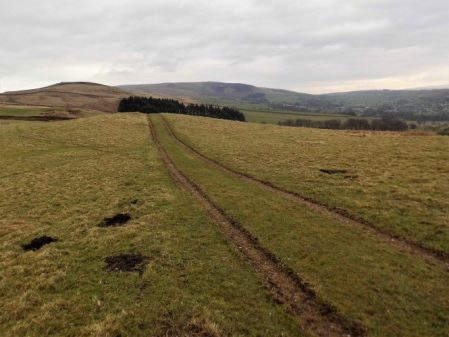
From here the route became moorland onto a ridge which was really an outlier of Pendle Fell, the mast marked on the map seems to have disappeared. We had climbed 500ft in a mile and were beginning to steam in the mild weather. Sabden could be seen in the distance. 
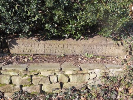
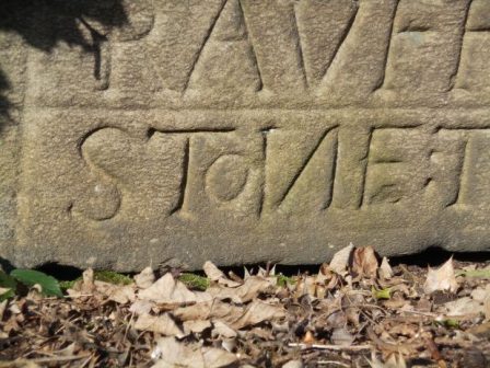
Below us was the large hidden valley of Sabden Brook and we slowly made our way down to pick up tracks into the village. I mentioned the famous Sabden Treacle Mines of which Sir Hugh had no knowledge, sadly they are no more and I will leave those with curiosity to investigate. We followed lanes to the 19th-century church and then out past a farm from where a pipe led into the fields. This pipe actually came out of the midden slurry tank and snaked into the fields, a tractor pump was starting up to inflate the pipe which we followed almost hypnotically for several fields. Eventually, the pipe seemed to connect up with another tractor with spreading machinery, but nothing happened. By now we realised we were off track so diverted back onto a rough farm road. This led to the 16th century Dean Farm with its wonderful mullioned windows and incongruous 19th-century extension.  Muddy fields and rough reedy grass below the ridge of the so-called Forest Of Pendle led us to lunch on the wall of Tinedale House. A climb onto the grandly named Rigg of England which was mainly equestrian farms. Up here were good views back to the massive bulk of Pendle and across to Newchurch in Pendle which we had visited on The Lancashire Witches Walk. Below to the south was the industrial Burnley – Nelson – Colne corridor. It didn’t look too bad from up here. Ancient tracks down the hillside brought us into Fence alongside the White Swan pub where I recalled a seasonal wild garlic meal.  Where do these memories unexpectedly come from?

We made a mistake in trying to follow footpaths parallel with the busy road, we were hemmed in by unnecessary plastic ‘hedging’ on the boundary of more equestrian enclosures. Escaping eventually into a large graveyard, where we were surprised by the number of Muslim graves. We started dropping down into the valley alongside a small beck. Surprisingly green paths led us into the heart of the Lomeshaye Industrial Estate. At the large Wellocks complex we enquired what  ‘The perfect ingredient‘ was but unfortunately only Polish was spoken. Subsequently, we discovered that it was a high-end food distribution firm to the restaurant trade founded originally by a potato merchant whom Sir Hugh had known from his Yorkshire days. It was pleasant to enter Nelson through Victoria Park with its bandstand and paths alongside Pendle Water.

Under the motorway, over the canal and then a steep road heading up into Nelson town centre where we found the modern bus station which gave us a busy ride back to Barrow.

*****


SKIPTON TO LONGRIDGE 3 – the two rivers.

Chatburn to Hodder Bridge.

As you may know I’m juggling a couple of routes giving winter walking, the northing SD38 across England with Sir Hugh and this shorter walk with The Pieman between our two towns. We meet up outside Hudson’s Ice Cream Parlour where we finished last time. I’ve enrolled JD [aka Doug] into today’s stroll, The Pieman appears from behind the ice cream cone.

We left the road by the church and followed paths down towards the river. An area popular with dog walkers judging by the number of poo bags hanging in hedges, I’ve given up commenting.

The Ribble was full with last night’s rain and snow melt. We were now on The Ribble Way skirting round the massive Horrocksford complex which produces a significant amount of England’s cement. The first bridge we came to was at West Bradford. After this we entered  a sculpture trail on the outskirts of Clitheroe. I think we missed most of the sculptures but noticed a few. None was outstanding.

After Brungerley Bridge we looked across to the impressive Waddow Hall a 17th century building owned by the Girls Guide Association and nowadays used as a wedding venue.Somewhere along here we passed muddy paddocks and then got sucked into new housing developments, they are everywhere, to arrive back onto the road at the sports centre. In the recreational ground we found a bench to watch the river go by and eat lunch. Edisford Bridge was built, at a former ford, in the 14th century and until 1600 was the only bridge upstream from Preston.

On the far side of the bridge is the eponymous hotel, having eaten we walked on by.

Complicated field paths led across to the complex of buildings at Withgill. All the while Kemple End, the eastern end of Longridge Fell, loomed above us, our onward route for another day.

The scenery improved and the paths became more interesting as we dropped down to the River Hodder.The river was crossed by the Higher Hodder Bridge with its historical boundary markings.This bridge is on our Skipton to Longridge line and from here our route will be up Kemple End and along Longridge Fell. But to finish off today we want to show the Yorkshireman some stunning scenery alongside the Hodder between the bridges.The familiar path undulates above the Hodder in splendid isolation. At one point a cross is seen, it has no inscription and local opinion is that it marks the spot of a drowning.Above us is the Stonyhurst estate and the long established Jesuit College. Down by the river are the remains of bathing houses where pupils changed before a bracing swim.And yet above us are buildings previously used by St. Mary’s Hall, a preparatory school for Stonyhurst College. It was closed in 1970 and converted into high-end living accommodation. There is a connection between Stonyhurst and Tolkien and hence there is a carving of Gandalf, the wizard, in the garden.

All that remained was a stroll alongside the Hodder to the Lower Bridge where the customany diversion was made onto Cromwell’s Bridge.

We had finished for the day. Rather mundane but highly enjoyable.

*****

NORTHING 438. LONGRIDGE TO BARROW [Whalley]

Pendle in all its glory.

A bus runs two hourly back to Longridge from Barrow, there is one at about 5pm.  My bus app says there is one due in 5 minutes, we should be OK.   As we approached we found ourselves in newly developing housing,  we took to the access road only to find it was blocked with that wire fencing erected around building sites. Panic followed as we peered through the fencing at the nearby bus stop. We didn’t have time to burrow Colditz style under the security barrier but with a little lateral thinking we made our escape onto a nearby lane and as we arrived at the road an unidentified bus was approaching. A desperate outstretched hand somehow halted the bus and we clambered on thanking the driver. We were home and dry.

The day had started more sedately with a stroll through housing estates in Longridge until we were level with the quarries at the top of town. The caravan site in the largest quarry was closed for a few weeks and there was no one climbing in the esoteric Craig Y Longridge. Here we left the roads and took to a bridleway below the incongruous ‘chalet’ development that was so controversial when planne, it pales into insignificance with todays developments in the town.The only thing of note was a new seat with an agricultural theme.

Walking on water.

Down the old lane we arrived at ‘The Written Stone’ which I’ve mentioned several times in local blogs.

What I hadn’t noticed before was the typo error where the carver had misspelt stone and added a small o later.  We then spent the morning traversing the southern side of Longridge Fell on paths and tracks between ancient farmsteads crunching through the snow in bright sunshine. One of the first farms, 250year old Hoardsall, has the appearance of years gone by. This morning the farmer was busy splitting logs, his source of fuel, in an outhouse with his black and white cat watching on. We fell into conversation and gleaned a fascinating history of sheep farming in the area. His farm yard was cobbled with local sandstone setts which had been augmented in the past with granite setts removed from Brook Street in Preston. [I knew of an antique  business which purchased old setts, street architecture, pub paraphernalia and red phone boxes etc when Preston was being ‘modernised’] A fascinating encounter which makes me think that these insights should be recorded for posterity.

New Row Cottages in Knowle Green formerly belonged to cotton weavers and are now a peaceful haven away from the main road.

Ahead was a tree topped hillock of unkown origin. Eventually we joined the delightful bridleway alongside Dean Brook into Hurst Green. One of my favourite walks. We lunched on a wall by the Shireburn Almshouses which were first built on Longridge Fell in 1706 but moved and rebuilt in Hurst Green in 1946. The village is closely associated with nearby Stoneyhurst College whose grounds we walked through. Much has been written about this famous Jesuit establishment. https://en.wikipedia.org/wiki/Stonyhurst  All the while a snowy Pendle loomed in the background.

Leaving the grounds we dropped down to cross the River Hodder at the historic border between Yorkshire and Lancashire. You take your life in your hands to view the inscription on the bridge and the nearby ‘Cromwells Bridge’

We did not enjoy the forced road walking into Mitton and were glad to escape into a quieter land leading to the 12th century All Hallows Church. Next door was the stately 17th century Great Mitton Hall. Downhill on the busy road we crossed the River Ribble with more views of an arctic Pendle Hill. This is fantastic Lancashire countryside. Pleasant field paths led us to our debacle with the new housing estate. The best day so far on our SD38 journey.There were signs of spring all along the way.

*****

FURTHER UPDATE ON SHORT WALK OBSTRUCTIONS.

Last June I experienced problems  on one of my regular short walks from home, barbed wire across the path. I reported the obstruction to LCC highway department.  A month later the obstruction had been temporarily removed though no stile provided. Early this month I had an email from the council stating that the fence has been opened up and a gate erected. This morning there was substantial snow and I wasn’t inclined to take the car onto the roads so later in the day, as there was some brightening, I thought it a good idea to do a walk and check the above footpath situation at the same time.

Once off the road I was on virgin snow, nice and crunchy. Surprisingly the first stile which was in good condition had been replaced by a kissing gate. Walking on I could see that the obstructed fence now also had a brand new gate. Problem resolved.

On closer inspection the gate had not been fitted correctly and wouldn’t close so the orange bailing twine was being utilised. Shoddy and no doubt expensive workmanship.

Anyhow I could now proceed with the walk which I continued across fields to Gill Bridge and then quiet back lanes to pass through the grounds of Ferraris Country Hotel. The bad weather had resulted in fewer visitors than usual.https://cdn.ostrovok.ru/t/1024x768/second2/1430170966/852be815eb041e63f83871d98193f8b2.jpg

The sun was making a brief feeble appearance as I walked home past the cricket pitch.

*****

A MISTY BEACON FELL.

Normally I can see Beacon Fell from my house – but not this morning. A freezing mist hung over the landscape. Not to be deterred I wanted to walk up there and back, in deference to the weather and my late start I took the car some part way. I know these footpaths well as I often do this walk or a variation, it is in fact the first section of my Longridge Skyline Walk.

The snow was disappearing from the fields as I set off. Soon I was walking through the first of several developments where an original farmhouse with its surrounding barns has morphed into an expensive looking ‘hamlet’. This one is based around Higher Barker.

Familiar field paths [I didn’t need a map today] lead to the Cross Keys Inn where holiday type units have been built around the site, none ready for occupation in what is a speculative development. The Cross Keys was a farm-cum-basic pub run by brothers and known affectionately and ironically by locals as The Dorchester. What of its future?

The lane ahead is always soggy and today was no exception. I could hear a woodpecker in the trees of Whitechapel.

The sun was trying to break through the mist as I crossed fields to Crombleholme Fold another group of houses old and new. The sheep were surprised to see me emerging from the gloom.

Still no view of Beacon Fell which I knew was looming up above me.  The trees were soon reached and as I entered them a small herd of Roe Deer passed in front of me seconds after taking this picture.

The car park at the visitor centre was virtually empty and I was the only one in the cafe where I enjoyed a good coffee. To reach the summit I followed the latest version of the walking snake, this one is expertly crafted from stone so should be more durable than the previous wooden sculpture.

I had the summit to myself with tantalising glimpses of Parlick and Fairsnape Fells through the mists.

A newish path, there are many since the storms of last year, and a concessionary bridleway through deciduos plantings took me out of the park.

A field footpath led me down to the fishing lake/holiday homes of Woodfold, another development which seems to be enlarging every time I pass this way. Do these places go under the planning radar?

My next aim was Barnsfold Farm environs where more sympathetic conversions were carried out decades ago.

Then it was muddy fields to Bullsnape Hall and back to my car just as the sun finally burst through. The final stile was a challenge.

An enjoyable day from nothing.

*****

WINTER ARRIVES ON MY DAILY WALK.


The moon was still bright and large while I was having my reviving first coffee, always the best of the day.

Overnight an inch of snow had softly fallen and now in the morning sunshine all was glistening white, time for that short walk before going out for lunch. I try to put in a few miles most days even if it is only my  daily walk cum shopping trip.

Out past the white cricket pitch and up the lane with views to the Bowland Fells, rabbits had been out much sooner than I.

Fields take me onto the toe of Longridge Fell, around the icy reservoir road with views to Beacon Fell.

I arrive for a peep into Craig Y Longridge. Despite the snow the rock was in perfect condition in the sunshine and if I hadn’t other appointments I would have been tempted back later for some bouldering.

I was soon down through the town, a quick supermarket dash and home for a second coffee. Oh and the lunch at The White Bull in Gisburn was excellent, I think I had worked up an appetite.

*****

SKIPTON TO LONGRIDGE 2 – winter sunshine.

Barnoldswick to Chatburn.

Late sunshine under Pendle.

In Gisburn churchyard hidden in the long grass is the grave of Francis Duckworth, 1862 – 1941.  One of my recent diversions has been searching for significant gravestones with the help of a book by Elizabeth Ashworth – Lancashire Who Lies Beneath? and I’d recently found his. He is remembered as the composer of the hymn tune ‘Rimington’. Have a listen –

https://hymnary.org/hymn/SCM/56

We had found a bench in Stoppers Lane for lunch opposite the Rimington Memorial Institute and on a nearby row of cottages I noticed this plaque –


JD [now aka Doug} the Pieman and myself had started outside a Rolls Royce factory in Barnoldswick and wandered indirectly through the mill streets as close as possible to our Skipton to Longridge line. It was a perfect sunny winter’s morning.Until the 1974 local government reorganisation historic ‘Barlick’ was in West Yorkshire, as several of the other villages visited today. The rivalry/frienship between the two roses counties is continued today and highlighted on some benches in town. We spent the morning navigating fields and lanes past both old and renovated farmsteads, through the hamlet of Howgill and into the scattered Rimington village. We were in close proximity to streams which eventually become Swanside Beck that joins the Ribble near Sawley.

To the northeast were Ingleborough and Penyghent and to the northwest Longridge Fell, Beacon Fell and Fairsnape.

After lunch using back lanes we seemed to avoid one of Rimington’s famous features – Cosgrove’s fashion shop. We dropped down to Ings Beck and Downham Mill.Soon the Ings Beck Joined Swanside Beck and we were alongside the familiar packhorse bridge. The next bridge we were on was that high one crossing the A59…… from where there was our last view of distant Ingleborough before we stroll down into Chatburn before the sun sets.

*****

NORTHING 438. COAST TO COAST.

An email dropped into my box –

What about:
Longridge to the Sea – Eastwards.
Following the OS line 38. I have had a quick look and it appears more or less possible. Straight line 104 miles and interesting – certainly a lot of new territory for me.  Conrad. 
[Sir Hugh to those familiar with this blog]

I ignored this for a day or so, thinking it was too ambitious, and I had better things to do; like finish off the GR131 in the Canary Islands and complete my protracted Land’s End to John o’Groats. But the idea gnawed at the back of my mind, and I foolishly looked up the maps. The SD 38 Northing in question runs virtually past my house. It becomes the SE38 and the TA38 further east, thus is better described as 438 Northing. My mind was in action now, why not start on the west coast and finish on the east, 122 straight miles Blackpool to Aldbrough.

A bit of a pipe dream. Better do some gardening.

SKIPTON TO LONGRIDGE 1 – another straight line.

Skipton to Barnoldswick.Following on from the success of the straight line from Longridge to Arnside completed with Sir Hugh at the end of last year I have persuadedthe piemana resident of Skipton to undertake a similar scheme between our respective abodes.

The Pieman.

He is a lifelong friend, possibly blood related though I tend to ignore that, with whom I’ve shared many backpacking trips throughout Europe but recently we have not been able to meet up as much as required. So this was a good opportunity to get 2019 off on a better note. Thus I was drinking coffee in his house in Skipton early this morning before setting off on what could only be described as a drab day.

My local guide takes us across Aireville Park, where I used to play as a child, over the Leeds Liverpool Canal and out of town through an industrial estate with some interesting relics awaiting restoration.

Airedale Park.

We crept under a main road and crossed the placid River Aire on an old track into Carleton. This essential bridge for our route was just within the mile either side of our arbitrary straight line  The C19 mill in the village was originally for cotton-spinning but I remember buying carpets there in the 70s, apparently it is now luxury apartments.

Carleton.

Today we didn’t visit the village but took to unmarked footpaths through green drumlin fields. I have to concede that satellite tracking maps were a great help in navigating this section. We were going parallel to a disused railway [Skipton to Colne] and eventually we found ourselves walking along it for convenience until stopped by vegetation.Possibly we touched on a Roman Road leading to Elslack where there was a fort. Our priority was to find a picnic bench and there right in the middle of the hamlet was one in some sort of memorial garden. Having put his instant coffee powder into a cup he looked for the flask containing the hot water, unfortunately it was on the worktop back in Skipton. I had hot apple tea in my flask so he ended up with a strange brew.

We walked past the C15 Elsack Hall but at a discreet distance and then along the abandoned railway into Thornton-in-Craven joining the Pennine Way for a short stretch. The village has interesting old houses but no shop or pub and the heavy traffic deterred us from lingering.

Tree planted for the Coronation of Queen Elizabeth.

?Millenium Clock.

On the edge of the village are Almshouses built for poor women, there is not much of that charity evident today.

By the church a sign guided us to a Holy Well in the grounds, dating from Saxon times it is covered by an octagonal structure erected in 1764 by the rector.

On a short stretch of golf course we joined The Pendle Way. It weaved around a church and graveyard where every grave was decorated with flowers, presumably from Christmas.

Rolls Royce have a large presence in Barnoldswick and we passed one of their factories before joining the Leeds – Liverpool Canal for the final stretch into town. My overall impression today was of green fields and a rich historical background.

*****

AROUND LONGRIDGE TO SEE WHAT’S NEW.

I was drinking coffee and debating whether to go for a stroll or even rescue my bike from the garage for a ride when JD phoned suggesting a walk, we chose a short one circumnavigating the village as I was interested in the changes taking place. On reflection if we’d had more time we should have climbed onto the fells to take advantage of the perfect weather.

Anyone who knows Longridge will be aware of the rash of indiscriminate housing developments. These are immediately obvious from the road where for some reason the football club have sold off a field within their grounds, previously used for youth training, for six houses. Already this is creating problems on match days as now their parking is limited there is dangerous parking on both sides of the busy road and footways, time will tell.  Across the road the cricket pitch is being surrounded by development. I was surprised to see this strange buiding practice…

Climbing up through the estate onto Higher Road was an alteration of a different sort, the local Thai restaurant’s entrance porch has been destroyed by drunken drivers badly affecting trade over the Xmas period.

There were however peaceful views from up here over the Spade Mill Reservoirs. The little the bridleway past the reservoirs is popular with dog walkers and leads onto Alston Lane. Once across we followed a farm lane and found our way into fields with occasional waymarkers, so we only lost our way once heading down to a bridge across a beck. The next farm, Alston Lodge, was a mud bath.

The path weaves its way between the Alston Reservoirs, built for Preston as it increased rapidly in size. A large group of Canada Geese had descended looking for food. Alongside the last stretch of water a wetland reserve has been created and there are hides to observe the birds. Today we saw mainly Mallards!

At the end of Pinfold Lane onto the main road all is changing with a large housing development on its north side and unfortunately a long stretch of hedging has been unnecessarily removed. Fortunately our onward footpath bypasses the development, for how long?  Mardale playing fields give us a bench for refreshments before we cross the old railway line into Shay Lane industrial area. An old path follows a small stream where one used to hop across on stones but recently a wooden bridge has appeared.  Green Nook Lane is usualy quiet but at he end are more new houses on the left and then even more being built across the road and guess what – an Aldi has arrived.

Round the corner is Halfpenny Lane whose fields will all be built on before my next walk round our previously lovely little community. So a day where the negatives outweighed the positives I think.

*****

CROASDALE/BULLSTONES WALK.

                                               Looking down a murky Croasdale.

One seldom meets another person in upper Croasdale, but today the Salter Fell track was busy with contractors making repairs to a steep section of the road above New Bridge. The road, also known as Hornby Road, dates from Roman times as Watling Street, which ran from Manchester to Carlisle.  It was along this road that the Lancashire Witches were taken from Clitheroe to Lancaster, and in fact, the last time I walked it was following a long distance walk called the Lancashire Witches Walk from Barrowford to Lancaster. Back to today, I was with JD, both of us needing some exercise. A lorry was taking stone up to the repairs, and the driver told us of the cost to Lancs. County Council, who apparently are obliged to maintain the highway, for whose benefit I’m not sure. An awful lot of potholes around Longridge could have been repaired for less. The repairs were extensive and thorough but not lot of work seemed to getting done today. More stone was being extracted from the higher quarry which in the past had been used for the construction of Stocks Reservoir dam in the thirties.

Track repairs with one of the Lancashire Witches Walk tercet waymarkers.

It took longer than usual to reach the top gate where we left the track and headed uphill through the heather. Looking westwards are views of upper Whitendale and remote Wolfhole Crag, this is wild Bowland country. I found the tiny sheep trod that traversed to the first group of Bull Stone boulders where we had our refreshments. The day was rather dull but there was no wind and silence prevails up here. Looking down the wide valley of Croasdale a misty Pendle rose in the distance. I had resisted bringing up my rock shoes but now regretted it as the conditions were perfect. Big boots would not have stuck to the friction slabs.

Sketch of the same scene from the Bowland Beth book mentioned below.

For a taste of the bouldering up here, have a look at  https://vimeo.com/183222521

We wandered on below more rocks, all bringing back memories to me, though JD had never been here. So it was a great pleasure to show him the massive stone trough carved on the hillside.

We found the little trod heading down valley, and at the ford we decided to continue down rough marshland to look at the bothy and surrounding sheep-pens. About ten years ago, I spent a couple of nights here with my teenage grandson whilst we explored the surrounding fells. In those days, Hen Harriers were a common sight on these Bowland fells, which were an important breeding ground for these beautiful birds. Things have gone downhill since then, with more and more persecution of raptors on grouse moors where the shooting lobbies run roughshod. I have just been reading a little book about the short life of Bowland Beth, born near this spot. A thoughtful analysis of the plight of wildlife on shooting estates.

Bowland Beth. The life of an English Hen Harrier.   David Cobham.     William Collins.

The bothy was unlocked, but animals had soiled the flagged floor. It did not look an attractive proposition for an overnight stay now, but would soon clean up.

Onwards down the valley with a few stream crossings and then we climbed back up the road passing on the way the remains of the House of Croasdale, a 17th century farmhouse built on the site of an ancient hunting lodge. It would have witnessed the witches being taken across the fells.

Remains of House of Croasdale.

An interesting circuit as usual, although a little sunshine would have helped with the photos.

*****

THE WAY OF THE CROW. Seventh day. Carnforth to Arnside.

Was today going to be anticlimax of lane walking  into Arnside?  No, with Sir Hugh’s local knowledge we weaved our way through unknown woods, nooks and crannies. Our plan a few week’s ago was to walk between our residences, they sound grand, as close as possible to a straight-line drawn on the map. We have actually kept it to within a kilometre of said line.

The road from the Carnforth/Warton marshes was busier than we had hoped so at the earliest opportunity we took a hidden path up onto the higher lane. We knew this area well from climbing on the  numerous limestone crags. Warton Main Quarry was a place to fill you with fear but the higher outcrops were far more attractive. We had met up at Warton Pinnacle Crag before.

Warton Main Quarry.

Passing on we dropped down to Crag Foot where there is a distinctive chimney, the remains of a pumping station for the low-lying fields that now are abandoned for the reed beds of Leighton Moss Reserve made famous for its Bitterns. The other chimney seen across the marshes at Jenny Brown’s Point is related to copper smelting works dating from the end of the 18th century.

Crag Foot Chimney.

Jenny Brown’s Point

Saltmarshes.

Soon we were crossing those saltmarshes towards an RSPB hide named in honour of Sir Eric Morecambe. We had no binoculars so we bypassed towards the wooded Heald Brow where a limestone track wandered through the woods towards Silverdale. This was all new to me and I was enjoying the atmosphere. Devious lanes and paths were taken around the edge of Silverdale through various National Trust Properties and despite a basic navigational error, not knowing which road we were on, we arrived at Waterslack Farm where I remembered a garden centre and cafe in days gone by. On the way we passed several wells, Lambert’s Meadow, Ancient woodlands, lots of limestone outcrops and The Row of houses. This whole area is worthy of detailed exploration.

Limestone pavement.

Burton Well Scar.

Lamberts Meadow.

Burton Well.

Dog Slack Well.

The Row.


The Black Dyke runs parallel with the railway into Arnside but we first had to have a look into Middlebarrow Quarry, a large abandoned limestone site where there would be climbing possibilities if it wasn’t on the dreaded private Dallam Estate land where any public access is unwelcome.

We heard shots in the distance and were wary of this guy with a high-powered rifle.

Black Dyke.

A final sting in the tail was when Sir Hugh launched up a steep slippery track to arrive into the village next to his house.

Mission accomplished before the end of 2018.  Happy New Year for 2019. What next.


*****


THE WAY OF THE CROW. Sixth day, The Lune to Carnforth.

                                                       We’ve had a lot of rain.

It was going to be difficult today to stay within the kilometre of our self-imposed straight line from my house in Longridge to Sir Hugh’s in Arnside. To get this far, as the crow flies, we had employed dubious means and been lucky with the positioning of important bridges. Another footpathless zone faced us this morning. Simple, said Sir Hugh just ask the farmer if we can tramp across his fields and walls, I wasn’t convinced.  In the mist we ghosted through the farmyard, not a dog barked or a cow stirred but there ahead was our adversary.  A burly farmer, I pushed Sir High forward with his simple proposition. Please sir… ” Yes just go down that field , through a gate and onwards.  But why didn’t you just follow the road?”  Our explanation seem to baffle him, as I thought it would. Rejoicing we ploughed on, the magic straight line was becoming our mantra.

Onwards.

The day had started back at Halton station, a few dog walkers were gathering. The bridge across the Lune was strange, it looked like a railway bridge but carried a single lane highway. The history here explains all…


Safely across we wandered through Halton, a mixture of old and new housing. As soon as we could field paths were followed on surprisingly undulating terrain, Both of us, recovering from chesty coughs, wheezed up hill. The forecast was wrong and we found ourselves in that miserable and annoyingly wetting mizzle. Before long the track to Stub Hall Farm was reached and our fate for the day in the farmer’s hands. A big thank you.

Once on the public footpath we relaxed into Nether Kellet and were soon going out on the wrong lane, a short cut was spotted across the recreational ground. Here was a war memorial to the Second World War from some distant benefactor.

Our next barrier, the M6, was easily crossed and some interesting paths taken through fields, woods and quarries.

Sacrilege to affix onto ancient stones.

We were intrigued by this standing water pipe curiosity.

The Lancaster Canal was reached and the adjacent A6 highway, a convenient seat for lunch next to a bus stop had locals peering at us through the condensed bus windows. I felt quite tramp like under their gaze. Although this was officially Carnforth we walked out through Crag Bank which seemed to have lots of old stone cottages, origins unknown. We were now in the drained marshlands of Morecambe Bay, today a little eerie with the mist.  Getting off the road proved difficult, a gate fell apart in my hands and we encountered impenetrable stiles in the march. Nobody uses the paths past Galley Hall. Another fortuitous bridge took us across the muddy River Keer and we were in the outskirts of Warton, the gloom preventing any views of the limestone crags above us. Hopefully the weather will be better for our last stretch into Arnside.


*****

THE WAY OF THE CROW. Fifth day, Postern Gate to The Lune.

                    The classic English countryside of Qurnmore Hall Park.

Quernmore Park estate forms the most formidable obstacle to our straight line route and over the last week in anticipation Sir Hugh and I have been plotting a military style assault. Using aerial photos and maps we have tried to find a way through, unobserved, without too many unclimbable fences, we have more plan A, B, C and D’s than the present Brexit debacle. There’s not a public footpath in sight. However our chief negotiator is highly skilled and has behind the scenes obtained permission from the owners to walk through on the forbidden lane. Here we are at the Postern Gate on a bright afternoon ready to stride past all the private signs to join the privileged classes.

The hall itself was well hidden behind walls and security gates.

To be honest we enjoyed our passage through the grounds even being greeted by the owner half way through.

At the end we emerged at the North Lodge onto a busy road, which would not have been pleasant or safe to walk along, a quick climb over a gate had us into a steep field leading down towards the River Lune. Fortunately another fence assault brought us onto the Lune Valley Ramble route and a clear walk along the old Lancaster to Wennington railway, closed under the Beeching axe in the 1960s and now a landscaped cycle path as far as Bull Beck, Caton. A complete contrast to the previous parkland.

On the opposite bank were new houses built since my last visit. They looked like affordable housing and were impressively roofed in solar panels.

The old station at Halton was busy, not with passengers but with students gathering for an afternoon’s rowing on the river. They have use of the listed building as a boat house which according to their coach costs a fortune.

A satisfying short walk through forbidden ground, all should be easy from now on.

*****

THE WAY OF THE CROW. Fourth day, Lentworth to Postern Gate, Quernmore.

                                                               Clougha Pike.

Serendipity – whilst we were looking for ways into the extensive private Quernmore Hall estate blocking our ongoing straight line a car drew up and out stepped the daughter of the owners! A pleasant chat ensured and we had their contact phone number for possible further progress on another day. But I’m getting ahead of myself.

Today should be easy walking , paths and lanes keep close to our ‘line’. Last night I’d been kept awake by heavy rainfall, frequent showers and gales were forecast but we set off and enjoyed sunshine and a bracing breeze. A quiet lane climbed away from the Wyre valley giving us a gentle warmup. Opposite the Quaker Friends Meeting House a carved stone was placed close to the stile we needed, we conjectured as to its antiquity. Once across a couple of swampy agricultural fields,  we approached a ramshackle farmyard, Low Moorhead, with trepidation, dogs and obstructions looked imminent. Another carved stone took our attention. As it happened the friendly farmer was busy nearby and we ascertained that he and his wife had created the stones rather than some medieval mason, we congratulated him on their artistry.

Most of the day we traversed Daleslike farmland below Grit Fell and Clougha Pike, gritstone moors above with Morecombe Bay spread out below. Our incursion onto the rough fell, boggy reeds, was not succesful and we were glad to hit the road and subsequently return into pheasant woods. The ‘beast from the east’ had been active here and we picked our way through the fallen trees.

Our incursion onto the rough fell, boggy reeds, was not succesful and we were glad to hit the road and subsequently return into pheasant woods. The ‘beast from the east’ had been active here and we picked our way through the fallen trees.

The last mile or so was along a supposedly quiet lane leading to those private woods above Postern Gate, the only highlight apart from a rainbow above the green valley was Quernmore Church.

*****


THE WAY OF THE CROW. Third day, Arbour to Lentworth Hall.

Distant Ward’s Stone Fell.

First a moan…                                                                                                                                             The Countryside and Rights of Way Act of 2000 ( the CROW Act, not the crow we are following )  gives a public right of access to land mapped as ‘open country’  known as open access land. A large area of the Bowland Fells are so designated which should give some degree of freedom to roam on the moorlands. However not all is as it seems. The 1:25,000 OS maps highlight open access land with  orange shading but the areas do not always link up with the public rights of way, creating a problem of reaching the access area in the first place. There are actually some ‘islands’ of access land with no access! This morning we are faced with one of these dilemmas, the lane back to Arbour is private for the first kilometre [red dots] so the logical way into the access area is denied legally. Who came up with these walker unfriendly ideas? I’m afraid those powerful landowners had too much influence when the plans were being drawn .Anyhow here we are back at the Arbour shooting lodge in its remote setting, ready for another ‘up and over’. Today we have to climb over Stake House and Grizedale Fells. There is still no sign of the rhino. We take the opportunity of some shelter by the lodge to divest of some clothing before the sweaty climb. A vague track is lost and then found as we puff up the steep slope alongside a series of very posh shooting butts. This track in fact takes us to the unmarked summit of Stake House, 402m, where we can admire views of Morecambe Bay, the Clougha Pike, Grit Fell, Ward’s Stone and Wolfhole Fell group with  the Trough Of Bowland spread out below. We take a compass bearing to a pond which should be near the start of the track at Grizesdale Head. We are in the middle of a wilderness here though the going is better than we’d anticipated, short heather and not too much bog. The weather is changeable!

A hazy Morecambe Bay with another storm coming in.


Wilderness – on a compass bearing.


Out of nowhere a gate in the boundary fence appears and this gives us easy access to the landrover track we are relying on to take us off the moors. We do so in swoops down the hillside as the weather takes a turn for the worse, wind and hail. At the road we are glad to hide behind a wall for lunch and watch the lazy antics of some contractors trying to offload fence posts. I do not envy their work outside in these conditions.

Opposite is a private lane to Catshaw Farms which is right on our route line, we wave enthusiastically at farm workers who pass us but nobody seems bothered by our presence. Once at the large farm complex we are back on public rights of way. Catshaw Hall Farm dates from the 17C, grade II listed with mullioned windows. There was work going on today.Muddy fields drop down towards the River Wyre where many trees are down from recent storms.   At a side stream the path has been washed away leading to some undignified bum sliding to reach the newly reconstructed footbridge. The bridge over The Wyre is made of sturdier timbers.  I realise have been here before.

Steep slippy steps bring us into fields belonging to Lentwoth Hall, now divided into apartments.

The final lane with ‘walking’ trees.

This whole area of Abbeystead is part of the Grosvenor estate owned by the Dukes Of Westminster. It holds the record for the biggest grouse bag in a day. On 12 August 1915, 2,929 birds were shot by eight shooters. We have survived the day through their estate and will carry on no doubt to trespass further estates on our straight line. I’m glad we finished when we did as the weather became atrocious, it’s the first day of winter tomorrow.

*****


THE WAY OF THE CROW. Second day, Bleasdale to Arbour, Calder Valley.

JD seemed worried when I described the next leg of our straight line way – “it is extremely rough going, the game keepers are unfriendly and there are rumours of a wild rhinoceros”. Despite all that he agreed to join us on his recommended shortened version. The picture above was taken from his house when I picked him up in the morning, The Bleasdale Fells which we had to cross are to the left of the higher Fairsnape group. Beacon Fell is far left.

The car park at Bleasdale Church was busy with Sunday worshippers.

It was a glorious sunny morning as we used field paths into the heart of Bleasdale discussing our individual Saturday night’s exploits, I probably had the largest hangover, Sir Hugh had been consructing a cat flap and JD entertaing his family.

Donning extra layers when we realised how cold it was.

No that’s not the rhino but pretty scary anyhow.

After the isolated Hazelhurst Farm we found the beginnings of a land rover track that would, via a series of zigzags, take us steeply into the open access area and onto the fell top. We puffed our way up with frequent stops to admire the views over the nearby Fairsnape/Parlick fells with Bleasdale and  the Fylde below. Surprisingly and fortunately another quad track led to the remote trig point, 429m, of Hazelhutst Fell. We are on grouse shooting moors up here and much has been written about the persecution of other wildlife in this vicinity to try to promote the shooting fraternity. Whatever one’s opinions about grouse shooting I am strongly against the wilful and unlawful killing of our protected species. On this stretch of the walk we came across several loaded Fenn Traps which are legally only allowed for stoat trapping [killing] but are known to trap other species. These are lethal looking spring-loaded traps which could almost take the tip off your walking pole.

From the trig point there were hazy views across Morecambe Bay to Black Combe and Barrow. Taking a compass bearing we set off across the heather in a NNW direction and fortunately found another quad bike track taking us down past shooting butts so avoiding all the heavy going. After what I’ve said about the grouse shooting land owners we were thankful for their tracks. The final descent was vertiginous. The surroundings were reminiscent of a Scottish Glen and we found the bridge over the Calder to the Victorian shooting cabin of Arbour. This must be one of the best kept secrets of Lancashire.

We found a sheltered spot out of the cold east wind for lunch. There were no windows into the shooting lodge to see the rhinoceros head. The story goes that a rhino escaped from a train near Garstang and had to be shot, it’s trophy head being mounted in the lodge.

By now all the excitement was over and we had an easy walk out on the track alongside the River Calder.  We were back at Sir Hugh’s car much sooner than we’d planned because of those good moorland tracks. We will have to walk back in next time to rejoin our line.

*****


THE WAY OF THE CROW. First day, Longridge to Bleasdale.

I was apprehensive, walking in a straight line as possible would take us on unfrequented paths, would the way be feasible. We left the village down overgrown Gypsy Lane and shortly after found a gate secured by a cord, a veritable Gordian Knot. Out came Sir Hugh’s, I’ll blame him, Swiss Army Knife and we were through.

‘Gypsy Lane’

We passed the ponds, ‘figure of eight’ where my children used to go fishing without much success but I’m sure they had an adventure away from parental supervision – they never drowned so I must have been doing something right.

The next farm-yard, where I’d previously climbed walls to escape, was now well signed and we even had a resident directing us to the hidden stile ahead though the accompanying foot plank, couldn’t call it a bridge, didn’t inspire confidence.

The slippery plank.

We reached a farm gate on a public footpath which was securely padlocked, no Swiss Army knife could cope, but as if on cue a lady drove up in her battered pick-up and opened up for us. Remonstrating about obstructed footpaths didn’t seem to be appropriate. All was pleasant rural scenery with scattered farms, some in better condition than others.

The next problem was of our creation, contentedly walking along the tiny River Loud we were almost in someone’s back garden when we realised we’d missed our path but fortunately a gate allowed our escape onto the road.

The infant Loud.

Things improved as we headed closer towards the Bowland Hills and Bleasdale. We passed the small rural Bleasdale School and headed for the church where our car was parked. We were last here in gale force Ali. A group of fell runners were just setting off for a quick few miles and we exchanged pleasantries. Walkers, climbers , cyclists, runners tend to have a common background.

Is that an Ofsted verdict?

We had completed the first leg of our project with very little deviation from the straight and narrow and to be honest no serious obstacles except a lot of slippery stiles. Our way ahead over Hazelhurst Fell could be seen, the fell runner is pointing the way, but will there be any paths?

Yet another slippery stile.

***** 

THE WAY OF THE CROW. LONGRIDGE TO ARNSIDE.

My good friend Sir Hugh  [http://conradwalks.blogspot.com/ ] inhabits that lovely village Arnside whereas I have to put up with the gross overdevelopment of Longridge. For the last few winters we have had projects to keep us active in the shorter days. He has emailed once or twice with suggestions for this year but nothing has struck me as original, boringly I seem to have walked most of the Long Distance Paths in the NW. I came up with a counter suggestion – why don’t we draw a straight line between our houses and follow it as closely as possible. I know this idea has been used before, particularly successfully  by Nic Crane on his straight line Two Degrees West journey from Berwick-on-Tweed to The Isle of Purbeck. I seem to remember he gave himself  a kilometre leeway either side but had a lot of media support, I wonder if we could be even stricter. True to form Sir High has taken the bait and the line has been drawn.

It is the wrong time of year for backpacking so we will split the route into day walks. The distance as the crow flies is 26.5 miles but we will be lucky to keep it under 35 miles. No rules except keeping as close to the line as possible preferably on footpaths or quiet lanes, legal ground or not. There are some obvious obstacles in the way – the fells of Bleasdale, the Rivers Wyre and Lune, Quernmore Hall Estate and the M6. It will be a challenge overcoming them, lets get started.

THE SEFTON COASTAL PATH. Formby to Crossens.

I’m the only person on the beach and I can hear music across the dunes,     yes that is the ‘Last Post’ being played and I realise it is the eleventh hour of the eleventh day of the eleventh month. What a place I’d found to quietly contemplate. Of course 2018 is 100 years since the end of WW1 and special events are being held, on the train this morning were army cadets off to one. I didn’t know at this time that back on Formby beach the face of one of the fallen soldiers was being temporally created in the sands. I’d arrived onto the southern end of Southport beach to escape the busy road I’d found myself walking on, another example of the present deficits of the Sefton Coastal Path.

An early start from my airbnb and I was back at Freshfield station and walking through the golf course which was already busy. In Ainsdale Dunes I followed the SCP as marked on my leaflet. This started really well through the woodland, no Red squirrels, and the undulating track was popular with dog walkers, runners and cyclists. The rain started heavily just as I emerged from the tree cover onto a less pleasant track so finding a marked trail leading back into the dunes and trees I blindly followed thinking it would take me back to the coast so I could avoid the busy coast road.

There were enticing tracks everywhere in this attractive wilderness and I somehow arrived at the depot of Natural England who care for the area. Sheltering under a store for a snack gave me time to speak to one of the wardens who admitted that it is a well kept secret. He pointed me on a way to the coast and I was back in the expansive dunes. Walking was not easy once the path was lost. As I headed for the coast I could see Pontins Holiday Camp looming in front of me and made the mistake of avoiding it on the right which had me alongside that busy road.

Simple but very effective stile on NE Reserve.

I don’t want to be here…

… or here.

After the dismal looking Pontins I continued for 2 miles up the lonely beach towards the pier and then began to worry about getting back to solid land before the tide turned, there seemed to be a lot of marshy grassland to cross. What followed was not pleasant, 300m of bog hopping with some sizeable channels  amongst the reeds, more serious than I thought. Time for a sit down and a sandwich – phew. Across the bay was Blackpool and Lytham, I’m just glad I won’t be attempting any more of the coast  – too many inlets to negotiate. By now the tide had come right in to the sea wall and the sun had come out.

What’s the history of this case?

Here is the start of the Trans Pennine Cycling Trail and there were sculptures to mark it. Seaside resorts look empty in the winter but the boating lake was busy. An easy stretch along the promenade was marred by the constant traffic.

Start of the Trans Pennine Trail.

At the first opportunity I took a side road which gave access to a lovely footpath across a golf course and then into the RSPB’s Marshside Reserves. The afternoon was sunny by now and the paths were popular with locals and their dogs. On my right was a housing estate and on the left the marshy reserves with lots of distant bird life but without binoculars identification becomes guesswork. Ahead I could see the distant Bowland Fells which appeared giants in the clear sky. At the end a walk alongside a Ribble Estuary drainage channel brought me conveniently to my bus stop home.

Sefton Coastal Walk has been mixed with plenty of highlights and quite a few lows. Some of the latter were unavoidable and some were my mistake, a decent map would help as would waymarking through the forests and dunes, and local knowledge of the beaches and tides.  I suspect it was designed by committee rather than enthusiastic walkers. Nonetheless a decent 23 mile walk fortunately blessed with decent weather.

*****