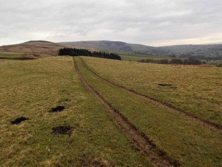
What could have been an uninspiring day in the hinterland of Bradford and Leeds turned out to be almost a green corridor of pleasant walking. It was not difficult to keep close to our lateral line with the proviso from Sir Hugh to incorporate a visit to his primary school in Thackley.
From the rail station in Saltaire we quickly reached the Leeds – Liverpool Canal to follow it off and on throughout the morning. At first all was industrial, historically relating to the canal with some fine mill buildings brought into the 21st century.
There were a few scattered sculptures including this one which was a pun on the Salt Mill connection…Hanging on the wall of my garage is an Ellis-Briggs cycle frame, probably 40years old, so I was delighted to pass their establishment which has been building steel frames since 1936. The cycling scene was booming in the 1930’s and the other notable established builder was W.R. Baines, whose factory was based at Thackley, see above and further into the walk. Coincidentally I rode a 1950’s Baines ‘Flying Gate’ cycle for many years.
Some nondescript scenery followed enlivened by some dubious and unsuccessful canal boat manoeuvering, it is difficult to do a three point turn.
Climbing away from the canal on cobbled paths above railway tunnels we entered Thackley, a mixture of old stone houses and modern estates, and found Sir Hugh’s school still open and extended since his time. Up here was the local cricket club with a very challenging sloping pitch, Sir Hugh’s father had been a member.
From the map we were not sure whether we could access the canal towpath from open country but thankfully there was a bridge. Soon we were sat on a bench looking down locks near Apperley Bridge, this was a busy stretch with pedestrians but no boat movements.Crossing busy orbital roads took time unless there were lights. We switched from the canal to follow the River Aire alongside the sports grounds of Woodhouse Grove School. The river continued through remarkably rural scenery despite being close to the railway and new housing developments.
Pleasant suburbs gave us twisting streets heading for Hawksworth Park which turned out to be a wooded valley. More parkland and upmarket housing and we arrived at our excellent budget hotel for the night.
There were several unexpected highlights on today’s walk and despite heading into the congested Aire Valley we enjoyed rural walking throughout on one of the warmest sunniest February days I remember.
Continuing our straight line walk meant once again logistics of two car parking. Sir Hugh suggested Saltaire as a finishing point so we arranged a rendezvous in the large free car park there, all went well with my journey until I became stuck in early rush hour traffic, not the best of starts for a day’s walking. With the late start and more traffic problems we drove back to our last point in the Ponden Valley. Sir Hugh seemed to know all these intricate Pennine roads and little villages or at least the lonely Public Houses where he spent his money when living in the area as a young man. We were stunned when the lane up to our isolated parking spot was closed necessitating back tracking and finding an alternative route on what was becoming a frustrating morning.
At last we set off down a bridleway high above Ponden Reservoir only for Sir Hugh to realise he’d left his phone on the car, fortunately we hadn’t gone far. This initiated a conversation on things left behind on walks and the cut off distance where one is prepared or able to return. Poles, passports, waterproofs, cameras and particularly hats were prominent on the list. We ran into problems with unmarked, difficult to follow and blocked paths in the Oldfield area and at West House farm admitted defeat and took to the road for a while. None the less there were many interesting houses passed.
High above Ponden Reservoir.
Before he’d realised his loss.
We were concerned with our poor progress after the delayed start on what would be a long day but as often happens things suddenly improved and remained so all day. We encountered a deep gorge not apparent on the map and decided to take the old flagged path alongside down to the River Worth which was then followed for a mile or so through green fields. We reached a road at an old mill that had been restored to provide modern living accommodation. There were several pack horse type bridges on this stretch reflecting the days when the valley was thriving with small riverside mills.
On the edge of Haworth I had noticed on the map a ‘Railway Children’s Walk’. The Railway Children by Edith Nesbit, published in 1906, was set in Yorkshire and a 1970 film used The Keighley and Worth Valley Railway as a backdrop. I remember watching a BBC TV series back in the 50s. Thus Haworth’s tourism benefits from both the Bronte connection and the preserved steam railway. We followed the lane across the Mytholmes railway tunnel made famous in the film …
… I regret now not going the extra few hundred yards to view the authentic Oakworth station featured prominently in the film. No trains today so we climbed up the steep hill to the busy Cross Roads and would you believe it – halfway up a steam train came into view way below us in the valley, bad timing. Up on the road the stone houses all bore that blackened look of the industrial past.
At Barcroft we reached high open countryside and enjoyed marching out with distant views to Bingley. In the fore ground was a prominent rocky tor, Catstones, and we speculated on the climbing possibilities and the height of the faces.
A bench below was perfect for lunch, I didn’t have the energy to ascend to the rocks. An inscription was dedicated to a Cllr. Ron Senior who pioneered a circular walk around Cullingworth, Senior Way. We felt well qualified to follow it.
We ended up just using the pavement through Harden but then entered St.Ives country park for a popular woodland walk to the edge of Bingley. The park is yet another old estate taken into council ownership providing a wide range of activities, we only skirted the edge.
A lane dropped down to bridges and fords at Beck Foot, a site of old mills, all very picturesque in the sun. An ecyclist proudly showed us his bike and extolled the virtues of battery powered leisure, not sure what it is doing for his fitness.
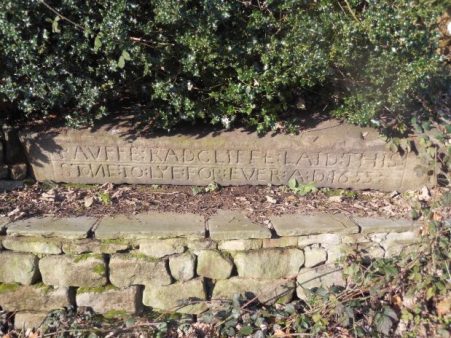
The River Aire, on its way into the industrial Leeds, was followed through fields to give another aspect to this day’s walk. Surprisingly rural although there was rubbish evident. A last stretch of woodland linked to the Leeds Liverpool Canal which took us into the heart of Salts Mill at Saltaire. Formerly a textile mill, now an arts centre, built by the philanthropic Sir Titus Salt in 1853, along with the adjoining Saltaire village in the hope of improving the conditions for working people. The whole complex is worthy of a day’s exploration. We found our car as the sun was setting and joined the heavy traffic home.
This was a day of two halves, first the transition from industrial Nelson to the complex field paths in its rural hinterland and then second glorious moorland walking over to Yorkshire.
We left the car in a dodgy carpark in Nelson assured by a couple of youths we wouldn’t get clamped. With nervous looks back we climbed modest streets eastwards towards Mecca or was that the local bingo hall. Views back down the streets showed a misty Pendle.
Anyhow we found ourselves in Marsden Hall Gardens which proved fascinating. Originally owned by the Walton family [more of them later] the estate passed into Nelson Corporation ownership in 1912. The 16th century hall still stands above the gardens. We came through the ‘Egyptian Gate’ a sandstone edifice with interesting carvings, most notably it is known as ‘the wishing gate’ and to this day people place leaves in the carved holes before passing through and making a wish.
Our next goal was an iron age fort marked on the map at Castercliff, despite its obvious size and prominence there was no local signage. It was constructed maybe 500 BC and there is no evidence it was ever occupied. The views from the summit over the towns in the Pendle Valley were hazy but retained the feeling of being up high. The way kept going upwards and ahead of us on a hill in the distance was the prominent monument to the Walton Family. A Victorian cross place atop a 9th century monolith which would warrant further close investigation.
The next hour or so found us navigating seldom used paths in rough fields between ancient farms. At one stage a Jack Russell harried us noisily for a good half mile through fields from its farm. At the time we were hopelessly lost and the farmer was shouting unclear directions. Things improved as we approached the south of Trawden, walking down a quiet lane we passed the idyllic and listed New Laith Farm. Once on the edge of town we turned off right into the narrow street of White Lee, old cottages gave way to new housing as we turned down an old mill lane to cross Trawden Brook and climb up to more Laith farms, the word meant granary or simply barn and is used a lot in northern England.
A working Will O’ Th’ Moon farm.
Residential New Laith Farm.
The way became rougher as we climbed higher. We found an enclosed track crossing the moorland to the west of Wycoller and lunch was taken high on this ‘Forest of Trawden’ looking over the Wycoller valley.
We dropped into the valley and made our way to Parson Lee Farm which we recognised from coming through on The Bronte Way last year. The winding track climbed slowly up into the moors, our journey pleasantly interrupted by a lengthy conversation with two passionate fell runners enabling Sir Hugh to reminisce on his one and only fell race.A trod took us across a wilderness to reach Watersheddles Reservoir, whereas last time we walked down the dangerous road from here today we found the concessionary path alongside the water. Up here we listened to Oyster Catchers by the shimmering water and Grouse and Curlews further afield, all very evocative.
There was only a short stretch of road before we turned up the quieter side road which gave us panoramic views over the Ponden area. We crossed The Pennine Way back to our car completing a satisfying 10 miles in perfect weather. Somewhere along the way we had crossed from Lancashire into Yorkshire which we will remain in for the rest of our route, so only the two great counties coast to coast.
Longridge Fell from the south, Kemple End is the steep bit at the right.
Higher Hodder Bridge to Longridge.
JD and I are sat in the bus station at Clitheroe waiting for the Skipton bus to arrive with the pieman on board. The alloted time passes and we wonder if we are in the right place, we circle the area in our car but no sign of him or the bus. The phone call elicits that the bus broke down! We look at each other and as the day is dismal and I lack enthusiasm we drive home for other pastimes, ie gardening.
Fast forward 24 hours and we are sat in Clitheroe bus station once again. I must admit the weather was far better today so we hoped the pieman would arrive. He did and within 10 minutes we are parked up at Higher Hodder Bridge at the base of Kemple End, the east end of Longridge Fell. After a stretch by the Hodder we start a fairly easy zigzag ascent of the fell. Behind us were views across the Ribble Valley to Pendle and Waddington Fell. We emerged at the road and stripped down to shirts for the rest of the 1000ft ascent in increasing temperatures.
Higher Hodder Bridge.
Climbing Kemple End, Pendle in the background.
Layers coming off.
A mixture of tracks and paths through the forest where there has been a lot of clearances of late, a magic route opened up in front of us. The lighting seemed to transport us to some alpine approach but there were no snowy peaks above. Familiar tracks head up the fell though in some places wind damaged trees create diversions. We came out of the trees at a well known viewpoint overlooking Bowland, the Three Yorkshire Peaks were in haze.
Magic light amongst the trees.
There is a way through.
More uprooted trees.
That viewpoint.
Our guest from Yorkshire is impressed by the scenery and we eventually arrive at Spire Hill the summit of Longridge Fell at 350m. At the trig point is a man talking on short wave radio as part of the Summits on the Air scheme. He was mainly concerned with radioing his position although he requested a summit photo. Listening in to his pointless conversation with some unknown person made me think why we climb summits. We were sweating from our exertion, ready for lunch, breathing in the air and enjoying the situation and views particulrly of Chipping Vale and the Bowland Hills. It takes all sorts.
Radio ham.
Well deserved lunch with a little Brexit chat.
We had been climbing steadily all morning but from now it was gently downhill. The view over the Fylde was rather hazy but the sunshine became warmer as the day wore on. There was some unavoidable road walking past the golf club. This now popular venue had humble beginnings as a 9 hole course which was amalgamated with Preston Cycling Club at the beginning of the 20th century. They built an early clubhouse shared with the golfers and as time passed the golf developed and the cyclists moved elsewhere but the badge still remembers the joint beginnings.
Heading down with Parlick and Fairsnape in the distance.
When it all started.
Present day signage.
We took to fields again and entered Longridge via the old railway line used by the stone quarries. We had spent the whole time walking Longridge Fell, about 7miles as the crow flies, hence its name. Cutting through the streets we completed our house to house route from Skipton. Well that’s another of my straight lines accomplished and very enjoyable it has been; beautiful varied scenery, interesting history and good companionship with enough exercise on each occasion to fill a winter’s day. But now Spring is upon us thoughts drift to wider horizons.
We are out walking our Northing 438 line again. A lane leads steeply out of Barrow through mainly new housing, ribbon development if ever I saw it. Crossing the busy A59 we continued climbing into Wiswell, an interesting little hamlet with a famous gastropub. A van was delivering organic vegetables to houses, one of these expensive subscription ideas where you probably finish each week with a box still full of potatoes and carrots. From here the route became moorland onto a ridge which was really an outlier of Pendle Fell, the mast marked on the map seems to have disappeared. We had climbed 500ft in a mile and were beginning to steam in the mild weather. Sabden could be seen in the distance. Below us was the large hidden valley of Sabden Brook and we slowly made our way down to pick up tracks into the village. I mentioned the famous Sabden Treacle Mines of which Sir Hugh had no knowledge, sadly they are no more and I will leave those with curiosity to investigate. We followed lanes to the 19th-century church and then out past a farm from where a pipe led into the fields. This pipe actually came out of the midden slurry tank and snaked into the fields, a tractor pump was starting up to inflate the pipe which we followed almost hypnotically for several fields. Eventually, the pipe seemed to connect up with another tractor with spreading machinery, but nothing happened. By now we realised we were off track so diverted back onto a rough farm road. This led to the 16th century Dean Farm with its wonderful mullioned windows and incongruous 19th-century extension. Muddy fields and rough reedy grass below the ridge of the so-called Forest Of Pendle led us to lunch on the wall of Tinedale House. A climb onto the grandly named Rigg of England which was mainly equestrian farms. Up here were good views back to the massive bulk of Pendle and across to Newchurch in Pendle which we had visited on The Lancashire Witches Walk. Below to the south was the industrial Burnley – Nelson – Colne corridor. It didn’t look too bad from up here. Ancient tracks down the hillside brought us into Fence alongside the White Swan pub where I recalled a seasonal wild garlic meal. Where do these memories unexpectedly come from?
We made a mistake in trying to follow footpaths parallel with the busy road, we were hemmed in by unnecessary plastic ‘hedging’ on the boundary of more equestrian enclosures. Escaping eventually into a large graveyard, where we were surprised by the number of Muslim graves. We started dropping down into the valley alongside a small beck. Surprisingly green paths led us into the heart of the Lomeshaye Industrial Estate. At the large Wellocks complex we enquired what ‘The perfect ingredient‘ was but unfortunately only Polish was spoken. Subsequently, we discovered that it was a high-end food distribution firm to the restaurant trade founded originally by a potato merchant whom Sir Hugh had known from his Yorkshire days. It was pleasant to enter Nelson through Victoria Park with its bandstand and paths alongside Pendle Water.
Under the motorway, over the canal and then a steep road heading up into Nelson town centre where we found the modern bus station which gave us a busy ride back to Barrow.
As you may know I’m juggling a couple of routes giving winter walking, the northing SD38 across England with Sir Hugh and this shorter walk with The Pieman between our two towns. We meet up outside Hudson’s Ice Cream Parlour where we finished last time. I’ve enrolled JD [aka Doug] into today’s stroll, The Pieman appears from behind the ice cream cone.
We left the road by the church and followed paths down towards the river. An area popular with dog walkers judging by the number of poo bags hanging in hedges, I’ve given up commenting.
The Ribble was full with last night’s rain and snow melt. We were now on The Ribble Way skirting round the massive Horrocksford complex which produces a significant amount of England’s cement. The first bridge we came to was at West Bradford. After this we entered a sculpture trail on the outskirts of Clitheroe. I think we missed most of the sculptures but noticed a few. None was outstanding.
After Brungerley Bridge we looked across to the impressive Waddow Hall a 17th century building owned by the Girls Guide Association and nowadays used as a wedding venue.Somewhere along here we passed muddy paddocks and then got sucked into new housing developments, they are everywhere, to arrive back onto the road at the sports centre. In the recreational ground we found a bench to watch the river go by and eat lunch. Edisford Bridge was built, at a former ford, in the 14th century and until 1600 was the only bridge upstream from Preston.
On the far side of the bridge is the eponymous hotel, having eaten we walked on by.
Complicated field paths led across to the complex of buildings at Withgill. All the while Kemple End, the eastern end of Longridge Fell, loomed above us, our onward route for another day.
The scenery improved and the paths became more interesting as we dropped down to the River Hodder.The river was crossed by the Higher Hodder Bridge with its historical boundary markings.This bridge is on our Skipton to Longridge line and from here our route will be up Kemple End and along Longridge Fell. But to finish off today we want to show the Yorkshireman some stunning scenery alongside the Hodder between the bridges.The familiar path undulates above the Hodder in splendid isolation. At one point a cross is seen, it has no inscription and local opinion is that it marks the spot of a drowning.Above us is the Stonyhurst estate and the long established Jesuit College. Down by the river are the remains of bathing houses where pupils changed before a bracing swim.And yet above us are buildings previously used by St. Mary’s Hall, a preparatory school for Stonyhurst College. It was closed in 1970 and converted into high-end living accommodation. There is a connection between Stonyhurst and Tolkien and hence there is a carving of Gandalf, the wizard, in the garden.
All that remained was a stroll alongside the Hodder to the Lower Bridge where the customany diversion was made onto Cromwell’s Bridge.
We had finished for the day. Rather mundane but highly enjoyable.
A bus runs two hourly back to Longridge from Barrow, there is one at about 5pm. My bus app says there is one due in 5 minutes, we should be OK. As we approached we found ourselves in newly developing housing, we took to the access road only to find it was blocked with that wire fencing erected around building sites. Panic followed as we peered through the fencing at the nearby bus stop. We didn’t have time to burrow Colditz style under the security barrier but with a little lateral thinking we made our escape onto a nearby lane and as we arrived at the road an unidentified bus was approaching. A desperate outstretched hand somehow halted the bus and we clambered on thanking the driver. We were home and dry.
The day had started more sedately with a stroll through housing estates in Longridge until we were level with the quarries at the top of town. The caravan site in the largest quarry was closed for a few weeks and there was no one climbing in the esoteric Craig Y Longridge. Here we left the roads and took to a bridleway below the incongruous ‘chalet’ development that was so controversial when planne, it pales into insignificance with todays developments in the town.The only thing of note was a new seat with an agricultural theme.
Walking on water.
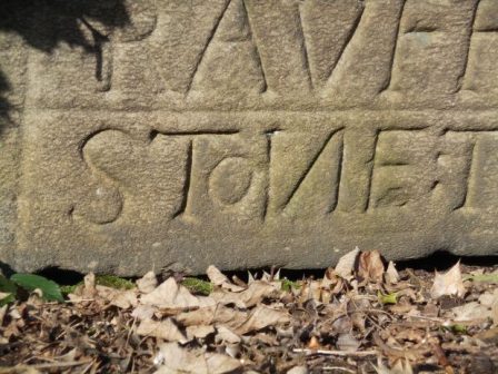
Down the old lane we arrived at ‘The Written Stone’ which I’ve mentioned several times in local blogs.
What I hadn’t noticed before was the typo error where the carver had misspelt stone and added a small o later. We then spent the morning traversing the southern side of Longridge Fell on paths and tracks between ancient farmsteads crunching through the snow in bright sunshine. One of the first farms, 250year old Hoardsall, has the appearance of years gone by. This morning the farmer was busy splitting logs, his source of fuel, in an outhouse with his black and white cat watching on. We fell into conversation and gleaned a fascinating history of sheep farming in the area. His farm yard was cobbled with local sandstone setts which had been augmented in the past with granite setts removed from Brook Street in Preston. [I knew of an antique business which purchased old setts, street architecture, pub paraphernalia and red phone boxes etc when Preston was being ‘modernised’] A fascinating encounter which makes me think that these insights should be recorded for posterity.
New Row Cottages in Knowle Green formerly belonged to cotton weavers and are now a peaceful haven away from the main road.
Ahead was a tree topped hillock of unkown origin. Eventually we joined the delightful bridleway alongside Dean Brook into Hurst Green. One of my favourite walks.We lunched on a wall by the Shireburn Almshouses which were first built on Longridge Fell in 1706 but moved and rebuilt in Hurst Green in 1946. The village is closely associated with nearby Stoneyhurst College whose grounds we walked through. Much has been written about this famous Jesuit establishment. https://en.wikipedia.org/wiki/Stonyhurst All the while a snowy Pendle loomed in the background.
Leaving the grounds we dropped down to cross the River Hodder at the historic border between Yorkshire and Lancashire. You take your life in your hands to view the inscription on the bridge and the nearby ‘Cromwells Bridge’
We did not enjoy the forced road walking into Mitton and were glad to escape into a quieter land leading to the 12th century All Hallows Church. Next door was the stately 17th century Great Mitton Hall. Downhill on the busy road we crossed the River Ribble with more views of an arctic Pendle Hill. This is fantastic Lancashire countryside. Pleasant field paths led us to our debacle with the new housing estate. The best day so far on our SD38 journey.There were signs of spring all along the way.
This is long distance walking in easy stages designed for winter exercise. Todays stage actually finishes in Longridge, my home town, which is convenient for me if not for Sir Hugh who has to travel from Arnside, but it was his idea in the first place. At least today we meet up in the agreed destination, a good start. We are walking by 9.30 on a clear sunny morning with a strong cold wind at our heals. There must have been a lot of rain last night judging by the pools on the road – an ominous sign. We take to footpaths as soon as we can and end up in deep mud similar to where we left off last week. The stiles around Singletons Farm are virtually impassable, blocked by hawthorn, but we push through.Crossing a field we are confronted by the next stile leading into a lake, no way we can go that way so we retreat and hit the minor lane to Cuddy Hill [sounds Scottish] and the well-known Plough Inn. After all the frustrating obstacles I was ready for a drink but of course they hadn’t opened. Eventually we find the onward path and emerge onto a lane which took us over a canal. In the past we have both walked the The Black and White, Lancaster Canal. but we didn’t recognise the location,
We were on the A6 for a short distance before crossing over onto tracks to end up in fields, navigational errors had us back tracking to reach Jepps Lane. The A6 seemed like the transition from the flat floodplain of The Fylde to the pleasant countryside of the Ribble Valley. The wind by now had intensified and many of Sir Hugh’s pearls of wisdom were lost. I had never been down the lane to Barton Old Hall before, but it conveniently crossed the motorway for us. The Old Hall was hidden behind trees and the cluster of houses and conversions at the hall were rather depressing.
I think we were deterred from the actual path through the properties, but still found ourselves in rolling countryside alongside the proverbial babbling brooks. Time passed as we weaved our way through the pleasant Lancashire countryside. The Bowland Fells rose in the background and ahead was a glimpse of Longridge Fell.
We passed the stately Goosnargh Lodge, joined some local routes and reached Goosnargh Mill, not the best of conversions.
I was now on home ground and confidently marched across fields finding hidden stiles until we reached one that was in such a dangerous state we had to retreat yet again and find an alternative way. Worse was to come as what had been open fields was divided up by permanent electric fencing, the sort used for equine enclosures, with no regard for any public rights of way. Attempts at crawling under on the wet ground were not pleasant, so we took to dismantling the top wires to step over, there was fortunately no electric current. Reports to LCC are on their way. A rather sour note towards the end of the day.
He who dares – SAS training.
Just before Longridge we passed Sea View cottages, and yes you could just about see back to the coast where we had started SD 38.The road into Longridge is now surrounded on all sides by new housing developments, the Fell can just be glimpsed above the roofs. It is no longer the attractive, honest, little town that I moved to all those years ago.
The night before I arrange with Sir Hugh where to meet up for our next stretch along northing 438 . I’m sat waiting at New Hall whilst he is sat waiting at Cuddy Hill a mile and a half away, a misunderstanding compounded by the wrong mobile numbers. Red faces and ‘mea culpa’ all round. Once communications are re-established we drive to Singleton to start walking later than we had planned. By now there is a glimpse of sunshine.
Singleton is an interesting village with an old PO, several lodges and halls, picturesque cottages, a fire engine shed and a Parish Church. The estate was developed from 1853 onwards by the Miller family, wealthy cotton manufacturers working with the Horrocks family in Preston. The estate is now held in trust and appears well maintained. There are permissive paths through the estate but we lack the maps to use them.
At Singleton Hall’s South Lodge the original gates bear the initials of Thomas Horrocks Miller and on the gate posts ‘Demi Wolves’ taken from the Miller coat of arms.
The old PO.
Lodge gates.
A Demi Wolf.
The timber-framed fire engine house is nearby, it has decorated plastered walls and a louvred bell tower. The engine was horse-drawn and before a fire could be attended the horse had to be rounded up in the adjacent field.
Estate cottages lined the lane and worshippers were leaving the church as we passed.
Thistleton, Elswick and Inskip villages were visited in turn. Not far off is the site of Cuadrilla’s controversial fracking wells and the local feeling is demonstrated by all the anti posters.
Does fracking cause earthquakes?
Todays walking was easy through fields but we lost count of the high awkward styles and muddy farm tracks.
The farms we passed were a mixture of traditional working and modernised for rich commuters. The strangest was an old thatched cottage with a very modern residence built within yards of it. Strange, who would want to do that?
Everywhere were ponds, former marl pits, that look as though they are used for fishing and duck shooting.
Elswick is known for the Bond’s ice cream shop, now more of a restaurant.
Inskip is known for RNAS Inskip, a former forces base and airfield. It is now used as a military high-frequency radio transmitting station and the antennae can be seen for miles in this flat landscape.
The last farmyard was the worst for muck just before we reached the car. Jolly Japes.
In Gisburn churchyard hidden in the long grass is the grave of Francis Duckworth, 1862 – 1941. One of my recent diversions has been searching for significant gravestones with the help of a book by Elizabeth Ashworth – Lancashire Who Lies Beneath? and I’d recently found his. He is remembered as the composer of the hymn tune ‘Rimington’. Have a listen –
We had found a bench in Stoppers Lane for lunch opposite the Rimington Memorial Institute and on a nearby row of cottages I noticed this plaque –
JD [now aka Doug} the Pieman and myself had started outside a Rolls Royce factory in Barnoldswick and wandered indirectly through the mill streets as close as possible to our Skipton to Longridge line. It was a perfect sunny winter’s morning.Until the 1974 local government reorganisation historic ‘Barlick’ was in West Yorkshire, as several of the other villages visited today. The rivalry/frienship between the two roses counties is continued today and highlighted on some benches in town. We spent the morning navigating fields and lanes past both old and renovated farmsteads, through the hamlet of Howgill and into the scattered Rimington village. We were in close proximity to streams which eventually become Swanside Beck that joins the Ribble near Sawley.
To the northeast were Ingleborough and Penyghent and to the northwest Longridge Fell, Beacon Fell and Fairsnape.
After lunch using back lanes we seemed to avoid one of Rimington’s famous features – Cosgrove’s fashion shop. We dropped down to Ings Beck and Downham Mill.Soon the Ings Beck Joined Swanside Beck and we were alongside the familiar packhorse bridge. The next bridge we were on was that high one crossing the A59…… from where there was our last view of distant Ingleborough before we stroll down into Chatburn before the sun sets.
Lunch time, Poulton-le-Fylde suburbia and we are sat in reclining chairs in someone’s front garden, This followed a trip by Sir Hugh depositing himself into the middle of the road with no serious injury but blood [as well as egg] on his face. It all looked dramatic to passing motorists who came to our aid and one particularly kind lady took us into her property for tea and sympathy. Spare glasses fitted and he was ready to continue on our walk along Northing 438
The day had started in a rather gloomy and windswept Blackpool where we picked up the 38 at North Shore. There is nothing to recommend British seaside resorts in winter. Sir Hugh had a new hat that kept blowing away until he stuffed it into his rucksack and donned a more suitable beanie. At the start is a striking statue to our emergency services which I’d seen before on a trip along this promenade.
Northing SD 38
We passed rows of basic guesthouses, probably full of ‘social housing clients’ and then followed the pavement alongside a not too busy road out to Warbreck where the Ministry of Pensions and whatever else has an office. A colleague of mine worked here for many years in some secret role to entrap fraudsters.
Branching into housing estates we weaved around crescents and groves. You think that they could have created pleasanter address names than Block 50 although some of the street names had a familiar ring.
We were heading for a green space shown on the map and eventually, a path was reached along the edge of the estate. I’d soon collected a fair amount of dog excrement on my boots although a responsible owner with two rescue German Shepherds was interesting to chat to. One of the dogs had cigarette burns inflicted upon it when he intervened but both dogs were now even-tempered. The border of the estate was a disgrace with every form of rubbish you could imagine thrown into the ditch, the mind boggles.
Green fields took us into the outskirts of Poulton where the housing improved but the navigation was complicated by dead ends.
After our ‘sedate lunch break’ we headed into the countryside [for how long] with cows, hens and sheep.
Unfortunately, our way further on was blocked at a closed level crossing and we diverted onto the busy main road and then had to negotiate a complex industrial estate which I didn’t think we would emerge from. Eventually, we squeezed between groaning industries into the countryside.
The country fields here are all recycled marshland and the draining ditches define the fields although the drainage is not always good.
All-day I’d been looking unsuccessfully for signs of spring, catkins etc but near a farm, I saw my first lambs of the year.
We finished in Singleton just as the rain started to beat a quick retreat to the car, it looks an interesting village so will delve further when we resume the SD38.
What about:
Longridge to the Sea – Eastwards.
Following the OS line 38. I have had a quick look and it appears more or less possible. Straight line 104 miles and interesting – certainly a lot of new territory for me. Conrad. [Sir Hugh to those familiar with this blog]
I ignored this for a day or so, thinking it was too ambitious, and I had better things to do; like finish off the GR131 in the Canary Islands and complete my protracted Land’s End to John o’Groats. But the idea gnawed at the back of my mind, and I foolishly looked up the maps. The SD 38 Northing in question runs virtually past my house. It becomes the SE38 and the TA38 further east, thus is better described as 438 Northing. My mind was in action now, why not start on the west coast and finish on the east, 122 straight miles Blackpool to Aldbrough.
Was today going to be anticlimax of lane walking into Arnside? No, with Sir Hugh’s local knowledge we weaved our way through unknown woods, nooks and crannies. Our plan a few week’s ago was to walk between our residences, they sound grand, as close as possible to a straight-line drawn on the map. We have actually kept it to within a kilometre of said line.
The road from the Carnforth/Warton marshes was busier than we had hoped so at the earliest opportunity we took a hidden path up onto the higher lane. We knew this area well from climbing on the numerous limestone crags. Warton Main Quarry was a place to fill you with fear but the higher outcrops were far more attractive. We had met up at Warton Pinnacle Crag before.
Warton Main Quarry.
Passing on we dropped down to Crag Foot where there is a distinctive chimney, the remains of a pumping station for the low-lying fields that now are abandoned for the reed beds of Leighton Moss Reserve made famous for its Bitterns. The other chimney seen across the marshes at Jenny Brown’s Point is related to copper smelting works dating from the end of the 18th century.
Crag Foot Chimney.
Jenny Brown’s Point
Saltmarshes.
Soon we were crossing those saltmarshes towards an RSPB hide named in honour of Sir Eric Morecambe. We had no binoculars so we bypassed towards the wooded Heald Brow where a limestone track wandered through the woods towards Silverdale. This was all new to me and I was enjoying the atmosphere. Devious lanes and paths were taken around the edge of Silverdale through various National Trust Properties and despite a basic navigational error, not knowing which road we were on, we arrived at Waterslack Farm where I remembered a garden centre and cafe in days gone by. On the way we passed several wells, Lambert’s Meadow, Ancient woodlands, lots of limestone outcrops and The Row of houses. This whole area is worthy of detailed exploration.
Limestone pavement.
Burton Well Scar.
Lamberts Meadow.
Burton Well.
Dog Slack Well.
The Row.
The Black Dyke runs parallel with the railway into Arnside but we first had to have a look into Middlebarrow Quarry, a large abandoned limestone site where there would be climbing possibilities if it wasn’t on the dreaded private Dallam Estate land where any public access is unwelcome.
We heard shots in the distance and were wary of this guy with a high-powered rifle.
Black Dyke.
A final sting in the tail was when Sir Hugh launched up a steep slippery track to arrive into the village next to his house.
Mission accomplished before the end of 2018. Happy New Year for 2019. What next.
It was going to be difficult today to stay within the kilometre of our self-imposed straight line from my house in Longridge to Sir Hugh’s in Arnside. To get this far, as the crow flies, we had employed dubious means and been lucky with the positioning of important bridges. Another footpathless zone faced us this morning. Simple, said Sir Hugh just ask the farmer if we can tramp across his fields and walls, I wasn’t convinced. In the mist we ghosted through the farmyard, not a dog barked or a cow stirred but there ahead was our adversary. A burly farmer, I pushed Sir High forward with his simple proposition. Please sir… ” Yes just go down that field , through a gate and onwards. But why didn’t you just follow the road?” Our explanation seem to baffle him, as I thought it would. Rejoicing we ploughed on, the magic straight line was becoming our mantra.
Onwards.
The day had started back at Halton station, a few dog walkers were gathering. The bridge across the Lune was strange, it looked like a railway bridge but carried a single lane highway. The history here explains all…
Safely across we wandered through Halton, a mixture of old and new housing. As soon as we could field paths were followed on surprisingly undulating terrain, Both of us, recovering from chesty coughs, wheezed up hill. The forecast was wrong and we found ourselves in that miserable and annoyingly wetting mizzle. Before long the track to Stub Hall Farm was reached and our fate for the day in the farmer’s hands. A big thank you.
Once on the public footpath we relaxed into Nether Kellet and were soon going out on the wrong lane, a short cut was spotted across the recreational ground. Here was a war memorial to the Second World War from some distant benefactor.
Our next barrier, the M6, was easily crossed and some interesting paths taken through fields, woods and quarries.
Sacrilege to affix onto ancient stones.
We were intrigued by this standing water pipe curiosity.
The Lancaster Canal was reached and the adjacent A6 highway, a convenient seat for lunch next to a bus stop had locals peering at us through the condensed bus windows. I felt quite tramp like under their gaze. Although this was officially Carnforth we walked out through Crag Bank which seemed to have lots of old stone cottages, origins unknown. We were now in the drained marshlands of Morecambe Bay, today a little eerie with the mist. Getting off the road proved difficult, a gate fell apart in my hands and we encountered impenetrable stiles in the march. Nobody uses the paths past Galley Hall. Another fortuitous bridge took us across the muddy River Keer and we were in the outskirts of Warton, the gloom preventing any views of the limestone crags above us. Hopefully the weather will be better for our last stretch into Arnside.
The classic English countryside of Qurnmore Hall Park.
Quernmore Park estate forms the most formidable obstacle to our straight line route and over the last week in anticipation Sir Hugh and I have been plotting a military style assault. Using aerial photos and maps we have tried to find a way through, unobserved, without too many unclimbable fences, we have more plan A, B, C and D’s than the present Brexit debacle. There’s not a public footpath in sight. However our chief negotiator is highly skilled and has behind the scenes obtained permission from the owners to walk through on the forbidden lane. Here we are at the Postern Gate on a bright afternoon ready to stride past all the private signs to join the privileged classes.
The hall itself was well hidden behind walls and security gates.
To be honest we enjoyed our passage through the grounds even being greeted by the owner half way through.
At the end we emerged at the North Lodge onto a busy road, which would not have been pleasant or safe to walk along, a quick climb over a gate had us into a steep field leading down towards the River Lune. Fortunately another fence assault brought us onto the Lune Valley Ramble route and a clear walk along the old Lancaster to Wennington railway, closed under the Beeching axe in the 1960s and now a landscaped cycle path as far as Bull Beck, Caton. A complete contrast to the previous parkland.
On the opposite bank were new houses built since my last visit. They looked like affordable housing and were impressively roofed in solar panels.
The old station at Halton was busy, not with passengers but with students gathering for an afternoon’s rowing on the river. They have use of the listed building as a boat house which according to their coach costs a fortune.
A satisfying short walk through forbidden ground, all should be easy from now on.
Serendipity – whilst we were looking for ways into the extensive private Quernmore Hall estate blocking our ongoing straight line a car drew up and out stepped the daughter of the owners! A pleasant chat ensured and we had their contact phone number for possible further progress on another day. But I’m getting ahead of myself.
Today should be easy walking , paths and lanes keep close to our ‘line’. Last night I’d been kept awake by heavy rainfall, frequent showers and gales were forecast but we set off and enjoyed sunshine and a bracing breeze. A quiet lane climbed away from the Wyre valley giving us a gentle warmup. Opposite the Quaker Friends Meeting House a carved stone was placed close to the stile we needed, we conjectured as to its antiquity. Once across a couple of swampy agricultural fields, we approached a ramshackle farmyard, Low Moorhead, with trepidation, dogs and obstructions looked imminent. Another carved stone took our attention. As it happened the friendly farmer was busy nearby and we ascertained that he and his wife had created the stones rather than some medieval mason, we congratulated him on their artistry.
Most of the day we traversed Daleslike farmland below Grit Fell and Clougha Pike, gritstone moors above with Morecombe Bay spread out below. Our incursion onto the rough fell, boggy reeds, was not succesful and we were glad to hit the road and subsequently return into pheasant woods. The ‘beast from the east’ had been active here and we picked our way through the fallen trees.
Our incursion onto the rough fell, boggy reeds, was not succesful and we were glad to hit the road and subsequently return into pheasant woods. The ‘beast from the east’ had been active here and we picked our way through the fallen trees.
The last mile or so was along a supposedly quiet lane leading to those private woods above Postern Gate, the only highlight apart from a rainbow above the green valley was Quernmore Church.
First a moan… The Countryside and Rights of Way Act of 2000 ( the CROW Act, not the crow we are following ) gives a public right of access to land mapped as ‘open country’ known as open access land. A large area of the Bowland Fells are so designated which should give some degree of freedom to roam on the moorlands. However not all is as it seems. The 1:25,000 OS maps highlight open access land with orange shading but the areas do not always link up with the public rights of way, creating a problem of reaching the access area in the first place. There are actually some ‘islands’ of access land with no access! This morning we are faced with one of these dilemmas, the lane back to Arbour is private for the first kilometre [red dots] so the logical way into the access area is denied legally. Who came up with these walker unfriendly ideas? I’m afraid those powerful landowners had too much influence when the plans were being drawn .Anyhow here we are back at the Arbour shooting lodge in its remote setting, ready for another ‘up and over’. Today we have to climb over Stake House and Grizedale Fells. There is still no sign of the rhino. We take the opportunity of some shelter by the lodge to divest of some clothing before the sweaty climb. A vague track is lost and then found as we puff up the steep slope alongside a series of very posh shooting butts. This track in fact takes us to the unmarked summit of Stake House, 402m, where we can admire views of Morecambe Bay, the Clougha Pike, Grit Fell, Ward’s Stone and Wolfhole Fell group with the Trough Of Bowland spread out below. We take a compass bearing to a pond which should be near the start of the track at Grizesdale Head. We are in the middle of a wilderness here though the going is better than we’d anticipated, short heather and not too much bog. The weather is changeable!
A hazy Morecambe Bay with another storm coming in.
Wilderness – on a compass bearing.
Out of nowhere a gate in the boundary fence appears and this gives us easy access to the landrover track we are relying on to take us off the moors. We do so in swoops down the hillside as the weather takes a turn for the worse, wind and hail. At the road we are glad to hide behind a wall for lunch and watch the lazy antics of some contractors trying to offload fence posts. I do not envy their work outside in these conditions.
Opposite is a private lane to Catshaw Farms which is right on our route line, we wave enthusiastically at farm workers who pass us but nobody seems bothered by our presence. Once at the large farm complex we are back on public rights of way. Catshaw Hall Farm dates from the 17C, grade II listed with mullioned windows. There was work going on today.Muddy fields drop down towards the River Wyre where many trees are down from recent storms. At a side stream the path has been washed away leading to some undignified bum sliding to reach the newly reconstructed footbridge. The bridge over The Wyre is made of sturdier timbers. I realise have been here before.
Steep slippy steps bring us into fields belonging to Lentwoth Hall, now divided into apartments.
The final lane with ‘walking’ trees.
This whole area of Abbeystead is part of the Grosvenor estate owned by the Dukes Of Westminster. It holds the record for the biggest grouse bag in a day. On 12 August 1915, 2,929 birds were shot by eight shooters. We have survived the day through their estate and will carry on no doubt to trespass further estates on our straight line. I’m glad we finished when we did as the weather became atrocious, it’s the first day of winter tomorrow.
JD seemed worried when I described the next leg of our straight line way – “it is extremely rough going, the game keepers are unfriendly and there are rumours of a wild rhinoceros”. Despite all that he agreed to join us on his recommended shortened version. The picture above was taken from his house when I picked him up in the morning, The Bleasdale Fells which we had to cross are to the left of the higher Fairsnape group. Beacon Fell is far left.
The car park at Bleasdale Church was busy with Sunday worshippers.
It was a glorious sunny morning as we used field paths into the heart of Bleasdale discussing our individual Saturday night’s exploits, I probably had the largest hangover, Sir Hugh had been consructing a cat flap and JD entertaing his family.
Donning extra layers when we realised how cold it was.
No that’s not the rhino but pretty scary anyhow.
After the isolated Hazelhurst Farm we found the beginnings of a land rover track that would, via a series of zigzags, take us steeply into the open access area and onto the fell top. We puffed our way up with frequent stops to admire the views over the nearby Fairsnape/Parlick fells with Bleasdale and the Fylde below. Surprisingly and fortunately another quad track led to the remote trig point, 429m, of Hazelhutst Fell. We are on grouse shooting moors up here and much has been written about the persecution of other wildlife in this vicinity to try to promote the shooting fraternity. Whatever one’s opinions about grouse shooting I am strongly against the wilful and unlawful killing of our protected species. On this stretch of the walk we came across several loaded Fenn Traps which are legally only allowed for stoat trapping [killing] but are known to trap other species. These are lethal looking spring-loaded traps which could almost take the tip off your walking pole.
From the trig point there were hazy views across Morecambe Bay to Black Combe and Barrow. Taking a compass bearing we set off across the heather in a NNW direction and fortunately found another quad bike track taking us down past shooting butts so avoiding all the heavy going. After what I’ve said about the grouse shooting land owners we were thankful for their tracks. The final descent was vertiginous. The surroundings were reminiscent of a Scottish Glen and we found the bridge over the Calder to the Victorian shooting cabin of Arbour. This must be one of the best kept secrets of Lancashire.
We found a sheltered spot out of the cold east wind for lunch. There were no windows into the shooting lodge to see the rhinoceros head. The story goes that a rhino escaped from a train near Garstang and had to be shot, it’s trophy head being mounted in the lodge.
By now all the excitement was over and we had an easy walk out on the track alongside the River Calder. We were back at Sir Hugh’s car much sooner than we’d planned because of those good moorland tracks. We will have to walk back in next time to rejoin our line.
I was apprehensive, walking in a straight line as possible would take us on unfrequented paths, would the way be feasible. We left the village down overgrown Gypsy Lane and shortly after found a gate secured by a cord, a veritable Gordian Knot. Out came Sir Hugh’s, I’ll blame him, Swiss Army Knife and we were through.
‘Gypsy Lane’
We passed the ponds, ‘figure of eight’ where my children used to go fishing without much success but I’m sure they had an adventure away from parental supervision – they never drowned so I must have been doing something right.
The next farm-yard, where I’d previously climbed walls to escape, was now well signed and we even had a resident directing us to the hidden stile ahead though the accompanying foot plank, couldn’t call it a bridge, didn’t inspire confidence.
The slippery plank.
We reached a farm gate on a public footpath which was securely padlocked, no Swiss Army knife could cope, but as if on cue a lady drove up in her battered pick-up and opened up for us. Remonstrating about obstructed footpaths didn’t seem to be appropriate. All was pleasant rural scenery with scattered farms, some in better condition than others.
The next problem was of our creation, contentedly walking along the tiny River Loud we were almost in someone’s back garden when we realised we’d missed our path but fortunately a gate allowed our escape onto the road.
The infant Loud.
Things improved as we headed closer towards the Bowland Hills and Bleasdale. We passed the small rural Bleasdale School and headed for the church where our car was parked. We were last here in gale force Ali. A group of fell runners were just setting off for a quick few miles and we exchanged pleasantries. Walkers, climbers , cyclists, runners tend to have a common background.
Is that an Ofsted verdict?
We had completed the first leg of our project with very little deviation from the straight and narrow and to be honest no serious obstacles except a lot of slippery stiles. Our way ahead over Hazelhurst Fell could be seen, the fell runner is pointing the way, but will there be any paths?
My good friend Sir Hugh [http://conradwalks.blogspot.com/ ] inhabits that lovely village Arnside whereas I have to put up with the gross overdevelopment of Longridge. For the last few winters we have had projects to keep us active in the shorter days. He has emailed once or twice with suggestions for this year but nothing has struck me as original, boringly I seem to have walked most of the Long Distance Paths in the NW. I came up with a counter suggestion – why don’t we draw a straight line between our houses and follow it as closely as possible. I know this idea has been used before, particularly successfully by Nic Crane on his straight line Two Degrees West journey from Berwick-on-Tweed to The Isle of Purbeck. I seem to remember he gave himself a kilometre leeway either side but had a lot of media support, I wonder if we could be even stricter. True to form Sir High has taken the bait and the line has been drawn.
It is the wrong time of year for backpacking so we will split the route into day walks. The distance as the crow flies is 26.5 miles but we will be lucky to keep it under 35 miles. No rules except keeping as close to the line as possible preferably on footpaths or quiet lanes, legal ground or not. There are some obvious obstacles in the way – the fells of Bleasdale, the Rivers Wyre and Lune, Quernmore Hall Estate and the M6. It will be a challenge overcoming them, lets get started.
 What could have been an uninspiring day in the hinterland of Bradford and Leeds turned out to be almost a green corridor of pleasant walking. It was not difficult to keep close to our lateral line with the proviso from Sir Hugh to incorporate a visit to his primary school in Thackley.

 Hanging on the wall of my garage is an Ellis-Briggs cycle frame, probably 40years old, so I was delighted to pass their establishment which has been building steel frames since 1936. The cycling scene was booming in the 1930’s and the other notable established builder was W.R. Baines, whose factory was based at Thackley, see above and further into the walk. Coincidentally I rode a 1950’s Baines ‘Flying Gate’ cycle for many years.


 Crossing busy orbital roads took time unless there were lights. We switched from the canal to follow the River Aire alongside the sports grounds of Woodhouse Grove School. The river continued through remarkably rural scenery despite being close to the railway and new housing developments.