Tag Archives: Walking.

MELLOR KNOLL AND THE HODDER.

Totridge Fell and Mellor Knoll from Burholme Bridge at the start of the walk.

Mellor Knoll is a 344m lump in Bowland, I didn’t actually climb it but I came close.

I was in my dormouse mode this morning and stayed in bed with my second coffee looking at maps whilst the day warmed up. Eventually, I stirred and drove out to park at Burholme Bridge on the River Hodder. Early morning cyclists were already returning from their Trough of Bowland circuit, a popular ride with Lancashire cyclists: one of the most prominent I met later in the day. I last cycled it 5 years ago.

A quiet lane leads up into the limestone area of Bowland with its Reef Knolls and caves.  A footpath brought me onto the farm track to Whitmore, a lonely farm at the base of Totridge Fell. In the past there were free-range hens wandering about although today the scattered wooden hen-houses looked deserted.


Welcoming committee.

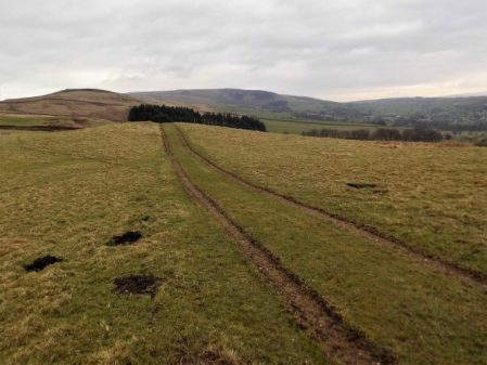
A bridleway takes off towards the woods on a track that was always muddy but tree felling has opened up the landscape and things are improved. This bridleway cuts through between the cone of Mellor Knoll and the parent fell of Totridge. Contouring the hillside was a joy with bluebells and fresh green beech leaves; views down to the snaking Hodder and the little known Birkett Fell, Waddington Fell and distant Pendle; towering above me was Totridge Fell with stone walls going straight up the steep slopes.

With all this excitement I wandered off course at the col and was heading the wrong way into Hareden Valley, it wouldn’t have mattered on this open ground but I traversed back to the correct track. Up here the hardy sheep only seem to have one lamb as opposed to their lowland softies with twins and triplets. 
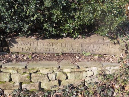
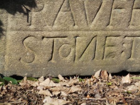
Oh and this is how to mend a wall…

I was now looking down on the farms of Hareden with the Trough of Bowland in the background. The hounds at the farm always give you a greeting long before you arrive.

Crossing Hareden Brook [dippers were seen] and then Langden Brook brought me onto a short stretch of The Trough of Bowland road.

Looking up the ‘Trough’ road.

I followed this for a short way before I could continue across fields to the water board road following the River Dunsop past cottages to the hamlet.

I’m sure these weren’t designed for outdoor seating.

Mellor Knoll above the new houses in Dunsop Bridge.

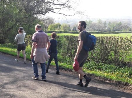
This is a popular walking area and lots of families were out enjoying the sunny weather and the delights of Dunsop Bridge hamlet – often cited as the geographic centre of Great Britain, although different measurements give different results. I passed the BT phone box which celebrates this fact.

A line of tall pines leads to Thornyholme Hall and farm over a bridge on the Hodder. The last time I passed here in 2013 a chain saw artist was just beginning rendering a stump into a statue of the thinking man and the results were seen today.


There is a lovely stretch along the River Hodder, ducks and their ducklings were swimming by the bridge and further on I watched sand martins going back and forth to their holes in a sandbank. If you click and enlarge the photo I actually caught some of them in flight and at the nest entrances. It was on this stretch I met an elderly couple walking towards me on a short river ramble, somehow the conversation turned to cycling and it transpired that the 80yr old gent was Dave Brown. He had been a prominent racing cyclist with impressive time trial results over all distances, only retiring after he had passed 70yrs. https://www.lancashiretelegraph.co.uk/sport/3829912.east-lancashire-cyclist-retires-after-53-years/  He told me he had written a weekly cycling column in the Lancashire Telegraph for 40 years until they recently decided to scrap it!  We swapped tales of cycling in the past, what a lovely chance encounter.

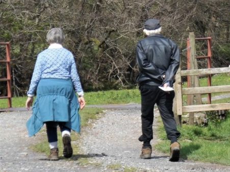
Soon I was back at Burholme Bridge having completed an interesting, if modest, 7 mile circuit feeling privileged to be living within this beautiful Bowland area.


*****


ZIG ZAGGING UP FAIRSNAPE.

The way to the zig zags.

From Bleasdale if the light is right one can see a zig zag track going up the southern slopes of Fairsnape. Today, Easter Sunday, the sun was strongly shining onto that slope and the way was not obvious but a look at the satellite map shows the track clearly from Higher Fairsnape Farm..Fairsnape is usually climbed from the outskirts of Chipping following tracks over Parlick but I have not used these zig zags and I thought today would be a good time to avoid the crowds. Sure enough when I reached Fell Foot the were already a dozen cars parked up, this is the spot where the paragliders start their trek up the hill. An insignificant footpath pointer on the corner led me into rough fields  where few go, but stiles some more substantial than others link up a pathless route which traverses round below Parlick to above Blindhurst farm.The sound of Lapwings and Curlews was everywhere, a hare popped up directly in front of me before disappearing into the distance. There seem to be an abundance of Orange Tip butterflies this year. There are new-born lambs and in the sky early paragliders. To my right is open access land [rough poor land that the landowners were happy to allow to be designated in the CRoW act] and it struck me that the colour of the land resembled the brown colouring on the 1:25,000 maps.

I dropped into a valley with a tributary of the River Brock and passed a green spot that would be ideal for a wild camp with my youngest grandchild if I could get him off his iPad. There was nobody about at Higher Fairsnape farm except new-born lambs. The buildings look old with mullioned windows and one wonders about the hardships of farming these remote places in the past and even now.

A signpost pointed the way on a concessionary path to reach the start of my zigzags. Once on the open fell I enjoyed a leisurely ascent up the well graded tracks, I always assume these tracks were for bringing peat down from the fells.

At one of the turns was the remains of a building, perhaps a shelter for the workers.

Years ago I can remember a similar structure with a disintegrating roof on the way up nearby Saddle Fell, it has now become a pile of stones but perhaps hides a sombre history.

On 26th March 1962 three siblings left home and travelled by bus to Chipping and walked over the fells, maybe to Langden Castle, on their return over Saddle Fell they were faced with severe winter conditions which result in the two brothers losing their lives due to hypothermia. Their sister Sheila survived to raise the alarm at Saddle End Farm. The brothers probably took shelter in the hut.  There was no Mountain Rescue Team in the area at that time so it was left to the police and locals to search, British Aircraft Corporation loaned their whirlwind helicopter to help. Shortly after this tragedy a South Ribble Rescue team was set up, now the local Bowland Pennine team.

  Above me were paragliders soaring the thermals and lots of people coming up the route from Parlick, I had seen nobody for two hours. My track came onto the plateau only a few hundred yards from the summit. Up here there is a cairn with Paddy’s Pole, a wind shelter and the trig point, 510m. I had a quick look around for a suitable bivi spot in the near future.

I was able to take a summit photo of a couple on their first ascent of Fairsnape and pointed out that the true summit, 520m, was half a mile away NE and that today conditions were perfect for visiting it as the peat hags that guard it have virtually dried up. I met up with them there later. the views were hazy – no Lakeland Hills or Three Peaks, Pendle and Longridge Fell were a blur.

520m summit.

A romp down the wallside and round Parlick. Looking back across Bleasdale towards Fairsnape showed no evidence of my zig zags. I walked below the popular spots for launching parapentes and many were still in the air. I passed a late starter walking up with his load.

The day was finished before lunch back at the road at Fell Foot.

*****


EVEN MORE OF DINKLEY ON A GOOD FRIDAY FAMILY WALK.

The successful walk last week along the Ribble must have been at the back of my mind when some of the family pitched up on Good Friday. So after a quick lunch of soup I suggested something similar as the weather was perfect. Parking at the Marles Wood site was tricky but we luckily managed a space as someone drove away. Since last week the bluebells have moved on a touch and the ‘blue carpet’ was making an appearance in the woods.

Sales Wheel.

A steady stream of walkers made their way through the woods to and from the river at Sales Wheel, early picnickers on the banks had been testing the cold water and were now relaxing with beers – typical Brits on holiday, some will have red skin tonight.

We pressed on to the open area along the river and descended to the shingle beach for a prolonged session of enthusiastic stone skimming. Despite the abundance of perfect flat stones none made it to the opposite bank.

After some time simple stone chucking became the order of the day before a drinks stop.

We admired the new bridge and noticed the plaque from the 1951 opening of the original suspension bridge, which I’d missed last time.

Rather than walk the long way back along the opposite bank, protestations from the grandchild, we decided to head uphill to the road on this side. Looking at the 1:25,000 I spotted a track going virtually all the way without too much road walking. Of course this was not a right of way but looked inviting so we went for it. This worked well and we followed tracks of sorts all the way without obstruction except at the end emerging onto the road where the gate was locked with dire warnings to trespassers. I was particularly pleased with the route which gave magnificent views back down to the river and the bridge as well as more distant views of Hurst Green, Longridge Fell and Pendle Hill, and brought us back to the car without too much family stress – we had only covered two miles in two hours.

‘forgive us our trespasses’


Back to my place for beers, bagatelle and Ratatouille.

*****

MORE OF THE RIBBLE WAY AND DINKLEY BRIDGE.

Following on from last Saturday’s walk from Hurst Green, JD and I decided on a section of the Ribble Way taking in the newly opened Dinkley Bridge.

We parked at Marle Wood carpark and crossed the road away from the river into fields rising above the valley behind what was Salesbury Hall. Unfamiliar views opened up over the Ribble Valley with Longridge Fell in the background as we ascended, and then suddenly Pendle was alongside us. No sooner than we were up, we were down, back at Ribchester Bridge over the Ribble. We were guided alongside properties converted from the former De Tabley Arms.

Downstream past the de Tabley.

Upstream.

Here we joined the Ribble Way, which goes upstream alongside the river as you would expect, but before long is diverted away from it because of anglers ‘rights. This has been a problem for this long-distance path in several places, thus depriving the walker of beautiful stretches of the river, an access problem that was never resolved, and I think resulting in the walk never gaining the popularity it could have. It feels a little neglected now.

The woods hereabout always have evidence of flooding, lots of twigs and logs, along with lots of plastic, but it is a delightful stretch nonetheless. Soon we were at Dinkley Bridge, reopened after several years since flood damage. The old suspension bridge has been replaced with an elegant, modern-looking structure with ramps at either end for access. Hopefully, it stands well above flood levels; it certainly doesn’t wobble like the old one.

I searched my photos for a picture of that suspension bridge in vain, so here is one from Lancashire Life.

On the far side, we rejoined the riverbank for the stroll downstream, which gave the best views of the bridge. We walked through fresh wild garlic, the bluebells were just starting to colour, wood sorrel, celendines and wood anemones were plentiful.   This mile alongside the river is popular because of the car park, which gives access to the shingle banks, goes through Marle Wood and looks over Sale Wheel, a whirlpool on a bend.

Long may this spring weather last.

*****

ANOTHER HURST GREEN CIRCULAR.

JD suggested a walk from Hurst Green, well actually he first suggested a circuit of Fairsnape Fell but I wasn’t feeling up to that but the day was too good to miss.

Our object today was to see if Dinkley Bridge over the Ribble was open again after a major rebuild following damage from Storm Desmond back in 2015 when flood waters buckled the upper part of the 1951 structure.   All pictures from my cheap phone.

We parked up in the village and made our way down to the magic Dean Brook. Just off the path  is a hidden rock face on which we put up a hard route 20 odd years ago, I was keen to have another look to assess any bouldering possibilities. The rock was still a bit green from the winter but there appeared to be plenty of clean rock low down, I will return to investigate.

Our route was to be circuitous to explore some unknown paths.  Searching for the first of these had us wandering into the back garden of the old hunting lodge of Greengore, we hastily retreated into the neighbouring field. Hidden stiles guided us across splendid Lancashire countryside to arrive at Higher Hud Lee Farm where an unlikely route took us through the untidy yards. On our way through we were press-ganged into helping two farmers push a car onto a low loader.

A stroll down the lane brought us to the long closed and now derelict Punch Bowl where another lane left the road heading for Bailey Hall. After a short distance we diverted to follow fields down to the thickly wooded Starling Brook and a footbridge. Once onto the next lane we were on familiar territory, or so we thought as all these lanes have a similar appearance. Strangely a small pond alongside seemed to have the remains of a speedboat embedded in it.

The Ribble Way joined us from the right and we followed the waymarks to Trough House where a diversion to the new Dinkley footbridge was made. What a splendid structure it appears though a trip to the far side would be needed for a proper view, an idea for next week. The old cantilevered structure has been  replaced. We were content to watch the Ribble flowing from the middle of the bridge. A lot of people were out and about enjoying the sunshine, many no doubt attracted by the new bridge’s opening.

The dogs at Trough House were in fine voice. Lambing Clough Lane climbed back up to Hurst Green where a wedding was in progress in The Shireburn Arms – what a day for it.

PS. The tyres on mountain bikes are getting bigger…

*****


NORTHING 438. HORSFORTH TO BARWICK IN ELMET.

It would be a challenge to find green footpaths across the north of Leeds so we ate a hearty breakfast. If we weren’t doggedly following SD38 we could have used the waymarked Leeds Country Way which skirts northern Leeds. Away at 9am the morning was cool but promised a clear day. Within a street or two of our hotel we entered Meanwood Park for an interesting mile of varied park and woodland – what a good start to the day. Even the incursion into strange David Lloyd territory gave us open access across a park into Moortown where we watched but failed to photo a low flying Red Kite, what a magnificent bird – how can people shoot them out of the skies?

Meanwood Park.

Anyone for the gym?

Blackthorn in profusion.

Our next aim was Roundhay Park and we had no option but to take to the pavements weaving through quiet streets.

Classic walking territory.

The park was busy with families enjoying the warm sunshine and open spaces. Our first priority was a coffee at the Mansion House overlooking the park. A stroll through the grass down to the lower lake, here we left the crowds and climbed up through the woods to cross Leeds Golf Course out onto a lane by Cobble Hall.

Grand entry to Roundhay Park.

Expensive coffee break.

Looking back at the Mansion.


Across another busy road was an industrial area where we thought we may be able to creep through to Red Hall, but no such luck new building is in progress and the whole area fenced and gated. We stood around wondering about some form of trespass when only 10yds away was a signed permissive path going in our direction. We skipped along pleased with our SD38 fortune and came out the other side en route.

No way …

… but how lucky are we?

A mile and a half straight rural road looked promising on the map but turned out to be the highway from hell, our worst section of the whole trip, I suspect it was a short cut out to the A1[M].

With relief we found a footpath, time for lunch and some peace and quiet. The scenery changed becoming rolling open fields, the start of the Wolds. Our destination was Barwick in Elmet a busy little village with a cross, the largest maypole I’ve ever seen [26m], a few good-looking pubs and more importantly a bus stop to Leeds.

Barwick in Elmet.

Leeds centre on a Saturday was all a buzz and we were glad to catch the crowded train back to Skipton. Two excellent days walking across the Bradford – Leeds corridor on surprisingly green paths.  We are now over halfway across our 438 line and looking forward to rural walking to the coast.

*****

LONGRIDGE FELL WANDERINGS.

A rather gloomy Longridge Fell with Pendle in the background.

I rose Phoenixlike from the ashes for a stroll on Longridge Fell. I had not been out for a month due to some chest infection or other and I wheezed my way round today. The weather was not the promised spring sunshine, in fact I wished I had donned an extra layer to cope with the cold wind.

I chose an anticlockwise circuit for some reason but before long this was denied to me by forestry work on wind-blown trees that had closed some paths. Over the last few years there has been a lot of tree felling partly due to fungal diseases attacking the spruce, and the edges of the remaining trees are susceptible to strong winds. I lost a Blue Spruce in my own garden two years ago and wonder whether I brought the disease back from the fell.

The diversions led me into parts of the forest long forgotten and rarely visited.

My favourite tree on the fell.

Approaching problems.

No further.

Deep in the hidden parts.

On the way back I enjoyed a  long open section past the trig point with decent views into Chipping Vale and across to the Bowland Hills. I met the only people I’d seen all day flying an extremely fast model glider.

The Bowland view.

What’s eating this?

The modern non-edible variety.

It was windy.

You can see from my plotted map that I walked an erratic route with some backtracking but managed 7 miles which pleased me.

*****

NORTHING 438. OLDFIELD TO SALTAIRE.

There were several unexpected highlights on today’s walk and despite heading into the congested Aire Valley we enjoyed rural walking throughout on one of the warmest sunniest February days I remember.

Continuing our straight line walk meant once again logistics of two car parking. Sir Hugh suggested Saltaire as a finishing point so we arranged a rendezvous in the large free car park there, all went well with my journey until I became stuck in early rush hour traffic, not the best of starts for a day’s walking. With the late start and more traffic problems we drove back to our last point in the Ponden Valley.  Sir Hugh seemed to know all these intricate Pennine roads and little villages or at least the lonely Public Houses where he spent his money when living in the area as a young man. We were stunned when the lane up to our isolated parking spot was closed necessitating back tracking and finding an alternative route on what was becoming a frustrating morning.

At last we set off down a bridleway high above Ponden Reservoir only for Sir Hugh to realise he’d left his phone on the car, fortunately we hadn’t gone far. This initiated a conversation on things left behind on walks and the cut off distance where one is prepared or able to return. Poles, passports, waterproofs, cameras and particularly hats were prominent on the list. We ran into problems with unmarked, difficult to follow and blocked paths in the Oldfield area and at West House farm admitted defeat and took to the road for a while. None the less there were many interesting houses passed.

High above Ponden Reservoir.

Before he’d realised his loss.

We were concerned with our poor progress after the delayed start on what would be a long day but as often happens things suddenly improved and remained so all day. We encountered a deep gorge not apparent on the map and decided to take the old flagged path alongside down to the River Worth which was then followed for a mile or so through green fields. We reached a road at an old mill that had been restored to provide modern living accommodation. There were several pack horse type bridges on this stretch reflecting the days when the valley was thriving with small riverside mills.

On the edge of Haworth I had noticed on the map a ‘Railway Children’s Walk’. The Railway Children by Edith Nesbit, published in 1906, was set in Yorkshire and a 1970 film used The Keighley and Worth Valley Railway as a backdrop. I remember watching a BBC TV series back in the 50s. Thus Haworth’s tourism benefits from both the Bronte connection and the preserved steam railway.  We followed the lane across the Mytholmes railway tunnel made famous in the film …

… I regret now not going the extra few hundred yards to view the authentic Oakworth station featured prominently in the film. No trains today so we climbed up the steep hill to the busy Cross Roads and would you believe it – halfway up a steam train came into view way below us in the valley, bad timing. Up on the road the stone houses all bore that blackened look of the industrial past.

At Barcroft we reached high open countryside and enjoyed marching out with distant views to Bingley. In the fore ground was a prominent rocky tor, Catstones, and we speculated on the climbing possibilities and the height of the faces.

A bench below was perfect for lunch, I didn’t have the energy to ascend to the rocks. An inscription was dedicated to a Cllr. Ron Senior who pioneered a circular walk around Cullingworth, Senior Way. We felt well qualified to follow it.

We ended up just using the pavement through Harden but then entered St.Ives country park for a popular woodland walk to the edge of Bingley. The park is yet another old estate taken into council ownership providing a wide range of activities, we only skirted the edge.

A lane dropped down to bridges and fords at Beck Foot, a site of old mills, all very picturesque in the sun. An ecyclist proudly showed us his bike and extolled the virtues of battery powered leisure, not sure what it is doing for his fitness.

The River Aire, on its way into the industrial Leeds, was followed through fields to give another aspect to this day’s walk. Surprisingly rural although there was rubbish evident. A last stretch of woodland linked to the Leeds Liverpool Canal which took us into the heart of Salts Mill at Saltaire. Formerly a textile mill, now an arts centre, built by the philanthropic Sir Titus Salt in 1853, along with the adjoining Saltaire village in the hope of improving the conditions for working people. The whole complex is worthy of a day’s exploration. We found our car as the sun was setting and joined the heavy traffic home.

*****

NORTHING 438. NELSON TO OLDFIELD.

This was a day of two halves, first the transition from industrial Nelson to the complex field paths in its rural hinterland and then second glorious moorland walking over to Yorkshire.

We left the car in a dodgy carpark in Nelson assured by a couple of youths we wouldn’t get clamped. With nervous looks back we climbed modest streets eastwards towards Mecca or was that the local bingo hall. Views back down the streets showed a misty Pendle.

Anyhow we found ourselves in  Marsden Hall Gardens which proved fascinating. Originally owned by the Walton family [more of them later] the estate passed into Nelson Corporation ownership in 1912. The 16th century hall still stands above the gardens. We came through the ‘Egyptian Gate’ a sandstone edifice with interesting carvings, most notably it is known as ‘the wishing gate’ and to this day people place leaves in the carved holes before passing through and making a wish.

Our next goal was an iron age fort marked on the map at Castercliff, despite its obvious size and prominence there was no local signage. It was constructed maybe 500 BC and there is no evidence it was ever occupied. The views from the summit over the towns in the Pendle Valley were hazy but retained the feeling of being up high. The way kept going upwards and ahead of us on a hill in the distance was the prominent monument to the Walton Family.  A Victorian cross place atop a 9th century monolith which would warrant further close investigation.

The next hour or so found us navigating seldom used paths in rough fields between ancient farms. At one stage a Jack Russell harried us noisily for a good half mile through fields from its farm. At the time we were hopelessly lost and the farmer was shouting unclear directions. Things improved as we approached the south of Trawden, walking down a quiet lane we passed the idyllic and listed New Laith Farm. Once on the edge of town we turned off right into the narrow street of White Lee, old cottages gave way to new housing as we turned down an old mill lane to cross Trawden Brook and climb up to more Laith farms, the word meant granary or simply barn and is used a lot in northern England.

A working Will O’ Th’ Moon farm.

Residential New Laith Farm.

The way became rougher as we climbed higher. We found an enclosed track crossing the moorland to the west of Wycoller and lunch was taken high on this  ‘Forest of Trawden’ looking over the Wycoller valley.

We dropped into the valley  and made our way to Parson Lee Farm which we recognised from coming  through on The Bronte Way last year. The winding track climbed slowly up into the moors, our journey pleasantly interrupted by a lengthy conversation with two passionate fell runners enabling Sir Hugh to reminisce on his one and only fell race. A trod took us across a wilderness to reach Watersheddles Reservoir, whereas last time we walked down the dangerous road from here today we found the concessionary path alongside the water. Up here we listened to Oyster Catchers by the shimmering water and Grouse and Curlews further afield, all very evocative.

There was only a short stretch of road before we turned up the quieter side road which gave us panoramic views over the Ponden area. We crossed The Pennine Way back to our car completing a satisfying 10 miles in perfect weather. Somewhere along the way we had crossed from Lancashire into Yorkshire which we will remain in for the rest of our route, so only the two great counties coast to coast.

*****


SKIPTON TO LONGRIDGE 4 – A sunny Longridge Fell.

Longridge Fell from the south, Kemple End is the steep bit at the right.

Higher Hodder Bridge to Longridge.

JD and I are sat in the bus station at Clitheroe waiting for the Skipton bus to arrive with the pieman on board. The alloted time passes and we wonder if we are in the right place, we circle the area in our car but no sign of him or the bus. The phone call elicits that the bus broke down! We look at each other and as the day is dismal and I lack enthusiasm we drive home  for other pastimes,  ie gardening.

Fast forward 24 hours and we are sat in Clitheroe bus station once again. I must admit the weather was far better today so we hoped the pieman would arrive. He did and within 10 minutes we are parked up at Higher Hodder Bridge at the base of Kemple End, the east end of Longridge Fell. After a stretch by the Hodder we start a fairly easy zigzag ascent of the fell. Behind us were views across the Ribble Valley to Pendle and Waddington Fell. We emerged at the road and stripped down to shirts for the rest of the 1000ft ascent in increasing temperatures.

Higher Hodder Bridge.

Climbing Kemple End, Pendle in the background.

Layers coming off.

A mixture of tracks and paths through the forest where there has been a lot of clearances of late, a magic route opened up in front of us. The lighting seemed to transport us to some alpine approach but there were no snowy peaks above. Familiar tracks head up the fell though in some places wind damaged trees create diversions. We came out of the trees at a well known viewpoint overlooking Bowland, the Three Yorkshire Peaks were in haze.

Magic light amongst the trees.

There is a way through.

More uprooted trees.

That viewpoint.

Our guest from Yorkshire is impressed by the scenery and we eventually arrive at Spire Hill the summit of Longridge Fell at 350m. At the trig point is a man talking on short wave radio as part of the Summits on the Air scheme.  He was mainly concerned with radioing his position although he requested a summit photo. Listening in to his pointless conversation with some unknown person made me think why we climb summits. We were sweating from our exertion, ready for lunch, breathing in the air and enjoying the situation and views particulrly of Chipping Vale and the Bowland Hills. It takes all sorts.

Radio ham.

Well deserved lunch with a little Brexit chat.

We had been climbing steadily all morning but from now it was gently downhill. The view over the Fylde was rather hazy but the sunshine became warmer as the day wore on. There was some unavoidable road walking past the golf club. This now popular venue had humble beginnings as a 9 hole course which was amalgamated with Preston Cycling Club at the beginning of the 20th century. They built an early clubhouse shared with the golfers and as time passed the golf developed and the cyclists moved elsewhere but the badge still remembers the joint beginnings.

Heading down with Parlick and Fairsnape in the distance.

When it all started.

Present day signage.

We took to fields again and entered Longridge via the old railway line used by the stone quarries. We had spent the whole time walking Longridge Fell, about 7miles as the crow flies, hence its name. Cutting through the streets we completed our house to house route from Skipton. Well that’s another of my straight lines accomplished and very enjoyable it has been; beautiful varied scenery, interesting history and good companionship with enough exercise on each occasion to fill a winter’s day. But now Spring is upon us thoughts drift to wider horizons.

*****

THE TOLKIEN TRAIL.

                                           THE WINKLEY OAK.

I was weary from my day’s exertions with Sir Hugh on our SD 38 walk which involved quite a bit of travelling time today so I asked JD to sort something out for the morrow whilst I soaked in the bath.

He had researched in a book ‘Birdwatching Walks In Bowland’ by David Hindle…

… and came up with The Tolkien Trail.

Author J.R.R. Tolkien regularly stayed at Stonyhurst College in the Ribble Valley whilst his son was studying there. It is thought, perhaps optimistically, that he derived inspiration for his Lord of the Rings trilogy from the surrounding scenery. So JD had conjured up a historical and ornithological walk for this lovely sunny day, if I’d thought I would have brought my binoculars.  There is plenty of information for The Tolkien Trail on the VisitLancashire web site.

We started in Hurst Green and were surprised at the amount of housing development creeping into the green fields. A well used path into Stonyhurst College sports grounds, but there is a new sport, clay pigeon shooting, and warning signs have been erected as well as a probably ineffective ‘alarm bell’.

I had recently been reading of the original observatory at the college built in 1838 and succeeded by the modern one in 1866. So as we approached the school buildings I was keen to identify them both, old and new.

We walked out past the gardener’s cottage and then the houses of Woodfields were masters live. Pleasant fields take you into Over Hacking Woods and a staircase down to meet the Hodder. We hadn’t seen many birds up to this point, apart from Robins singing full throat, but the woods had a truly Tolkien atmosphere.

Below us were the original ruined changing rooms for the college’s swimming lessons in the river, I think they have an indoor pool nowadays. I mentioned these in a recent post when we passed this way. Up the slope is Hodder Court previously a preparatory school, but now private dwellings with a statue of Gandalf in one of the gardens. shame the trail leaflet doesn’t mention it. See the above post for pictures.

An Australian couple were following us with their friendly dog and it couldn’t wait to get immersed in the river. We saw a few ducks along this wonderful stretch of the Hodder.

This was the third time I’d arrived at Lower Hodder Bridge in a week so didn’t intend to show more views of ‘Cromwell’s Bridge’ however when we joined The Ribble Way and rose above the river there was a good view back down to the two bridges.

We knew about the heronry in the tall trees next to Winkley Hall Farm and sure enough we saw Herons flying in to their nests. Whilst watching them I spotted a small bird flitting through the hedge, a rare sight of a Gold Crest.

Where the Hodder meets the Ribble we found a fisherman’s hut with a bench, a perfect spot for lunch and watching the rivers run by.

Along the next stretch is the site of Hacking Ferry used until 1955, the last boat is in Clitheroe Castle Museum apparently. Across the river is the 17th century Hacking Hall near where the Calder enters the Ribble.

An Egret was spotted on the far bank, a couple of Canada Geese also but no Kingfishers or Dippers.

Before long we left the river and headed back to Hurst Green coming through the car park of the Shireburn Arms, we were tempted by a pint but looking at the state of our muddy boots decided not to. All day Pendle had been brooding in the background.

*****

NORTHING 438. BARROW TO NELSON.

We are out walking our Northing 438 line again. A lane leads steeply out of Barrow through mainly new housing, ribbon development if ever I saw it. Crossing the busy A59 we continued climbing into Wiswell, an interesting little hamlet with a famous gastropub. A van was delivering organic vegetables to houses, one of these expensive subscription ideas where you probably finish each week with a box still full of potatoes and carrots. From here the route became moorland onto a ridge which was really an outlier of Pendle Fell, the mast marked on the map seems to have disappeared. We had climbed 500ft in a mile and were beginning to steam in the mild weather. Sabden could be seen in the distance. Below us was the large hidden valley of Sabden Brook and we slowly made our way down to pick up tracks into the village. I mentioned the famous Sabden Treacle Mines of which Sir Hugh had no knowledge, sadly they are no more and I will leave those with curiosity to investigate. We followed lanes to the 19th-century church and then out past a farm from where a pipe led into the fields. This pipe actually came out of the midden slurry tank and snaked into the fields, a tractor pump was starting up to inflate the pipe which we followed almost hypnotically for several fields. Eventually, the pipe seemed to connect up with another tractor with spreading machinery, but nothing happened. By now we realised we were off track so diverted back onto a rough farm road. This led to the 16th century Dean Farm with its wonderful mullioned windows and incongruous 19th-century extension.  Muddy fields and rough reedy grass below the ridge of the so-called Forest Of Pendle led us to lunch on the wall of Tinedale House. A climb onto the grandly named Rigg of England which was mainly equestrian farms. Up here were good views back to the massive bulk of Pendle and across to Newchurch in Pendle which we had visited on The Lancashire Witches Walk. Below to the south was the industrial Burnley – Nelson – Colne corridor. It didn’t look too bad from up here. Ancient tracks down the hillside brought us into Fence alongside the White Swan pub where I recalled a seasonal wild garlic meal.  Where do these memories unexpectedly come from?

We made a mistake in trying to follow footpaths parallel with the busy road, we were hemmed in by unnecessary plastic ‘hedging’ on the boundary of more equestrian enclosures. Escaping eventually into a large graveyard, where we were surprised by the number of Muslim graves. We started dropping down into the valley alongside a small beck. Surprisingly green paths led us into the heart of the Lomeshaye Industrial Estate. At the large Wellocks complex we enquired what  ‘The perfect ingredient‘ was but unfortunately only Polish was spoken. Subsequently, we discovered that it was a high-end food distribution firm to the restaurant trade founded originally by a potato merchant whom Sir Hugh had known from his Yorkshire days. It was pleasant to enter Nelson through Victoria Park with its bandstand and paths alongside Pendle Water.

Under the motorway, over the canal and then a steep road heading up into Nelson town centre where we found the modern bus station which gave us a busy ride back to Barrow.

*****


SKIPTON TO LONGRIDGE 3 – the two rivers.

Chatburn to Hodder Bridge.

As you may know I’m juggling a couple of routes giving winter walking, the northing SD38 across England with Sir Hugh and this shorter walk with The Pieman between our two towns. We meet up outside Hudson’s Ice Cream Parlour where we finished last time. I’ve enrolled JD [aka Doug] into today’s stroll, The Pieman appears from behind the ice cream cone.

We left the road by the church and followed paths down towards the river. An area popular with dog walkers judging by the number of poo bags hanging in hedges, I’ve given up commenting.

The Ribble was full with last night’s rain and snow melt. We were now on The Ribble Way skirting round the massive Horrocksford complex which produces a significant amount of England’s cement. The first bridge we came to was at West Bradford. After this we entered  a sculpture trail on the outskirts of Clitheroe. I think we missed most of the sculptures but noticed a few. None was outstanding.

After Brungerley Bridge we looked across to the impressive Waddow Hall a 17th century building owned by the Girls Guide Association and nowadays used as a wedding venue.Somewhere along here we passed muddy paddocks and then got sucked into new housing developments, they are everywhere, to arrive back onto the road at the sports centre. In the recreational ground we found a bench to watch the river go by and eat lunch. Edisford Bridge was built, at a former ford, in the 14th century and until 1600 was the only bridge upstream from Preston.

On the far side of the bridge is the eponymous hotel, having eaten we walked on by.

Complicated field paths led across to the complex of buildings at Withgill. All the while Kemple End, the eastern end of Longridge Fell, loomed above us, our onward route for another day.

The scenery improved and the paths became more interesting as we dropped down to the River Hodder.The river was crossed by the Higher Hodder Bridge with its historical boundary markings.This bridge is on our Skipton to Longridge line and from here our route will be up Kemple End and along Longridge Fell. But to finish off today we want to show the Yorkshireman some stunning scenery alongside the Hodder between the bridges.The familiar path undulates above the Hodder in splendid isolation. At one point a cross is seen, it has no inscription and local opinion is that it marks the spot of a drowning.Above us is the Stonyhurst estate and the long established Jesuit College. Down by the river are the remains of bathing houses where pupils changed before a bracing swim.And yet above us are buildings previously used by St. Mary’s Hall, a preparatory school for Stonyhurst College. It was closed in 1970 and converted into high-end living accommodation. There is a connection between Stonyhurst and Tolkien and hence there is a carving of Gandalf, the wizard, in the garden.

All that remained was a stroll alongside the Hodder to the Lower Bridge where the customany diversion was made onto Cromwell’s Bridge.

We had finished for the day. Rather mundane but highly enjoyable.

*****

NORTHING 438. LONGRIDGE TO BARROW [Whalley]

Pendle in all its glory.

A bus runs two hourly back to Longridge from Barrow, there is one at about 5pm.  My bus app says there is one due in 5 minutes, we should be OK.   As we approached we found ourselves in newly developing housing,  we took to the access road only to find it was blocked with that wire fencing erected around building sites. Panic followed as we peered through the fencing at the nearby bus stop. We didn’t have time to burrow Colditz style under the security barrier but with a little lateral thinking we made our escape onto a nearby lane and as we arrived at the road an unidentified bus was approaching. A desperate outstretched hand somehow halted the bus and we clambered on thanking the driver. We were home and dry.

The day had started more sedately with a stroll through housing estates in Longridge until we were level with the quarries at the top of town. The caravan site in the largest quarry was closed for a few weeks and there was no one climbing in the esoteric Craig Y Longridge. Here we left the roads and took to a bridleway below the incongruous ‘chalet’ development that was so controversial when planne, it pales into insignificance with todays developments in the town.The only thing of note was a new seat with an agricultural theme.

Walking on water.

Down the old lane we arrived at ‘The Written Stone’ which I’ve mentioned several times in local blogs.

What I hadn’t noticed before was the typo error where the carver had misspelt stone and added a small o later.  We then spent the morning traversing the southern side of Longridge Fell on paths and tracks between ancient farmsteads crunching through the snow in bright sunshine. One of the first farms, 250year old Hoardsall, has the appearance of years gone by. This morning the farmer was busy splitting logs, his source of fuel, in an outhouse with his black and white cat watching on. We fell into conversation and gleaned a fascinating history of sheep farming in the area. His farm yard was cobbled with local sandstone setts which had been augmented in the past with granite setts removed from Brook Street in Preston. [I knew of an antique  business which purchased old setts, street architecture, pub paraphernalia and red phone boxes etc when Preston was being ‘modernised’] A fascinating encounter which makes me think that these insights should be recorded for posterity.

New Row Cottages in Knowle Green formerly belonged to cotton weavers and are now a peaceful haven away from the main road.

Ahead was a tree topped hillock of unkown origin. Eventually we joined the delightful bridleway alongside Dean Brook into Hurst Green. One of my favourite walks. We lunched on a wall by the Shireburn Almshouses which were first built on Longridge Fell in 1706 but moved and rebuilt in Hurst Green in 1946. The village is closely associated with nearby Stoneyhurst College whose grounds we walked through. Much has been written about this famous Jesuit establishment. https://en.wikipedia.org/wiki/Stonyhurst  All the while a snowy Pendle loomed in the background.

Leaving the grounds we dropped down to cross the River Hodder at the historic border between Yorkshire and Lancashire. You take your life in your hands to view the inscription on the bridge and the nearby ‘Cromwells Bridge’

We did not enjoy the forced road walking into Mitton and were glad to escape into a quieter land leading to the 12th century All Hallows Church. Next door was the stately 17th century Great Mitton Hall. Downhill on the busy road we crossed the River Ribble with more views of an arctic Pendle Hill. This is fantastic Lancashire countryside. Pleasant field paths led us to our debacle with the new housing estate. The best day so far on our SD38 journey.There were signs of spring all along the way.

*****

FURTHER UPDATE ON SHORT WALK OBSTRUCTIONS.

Last June I experienced problems  on one of my regular short walks from home, barbed wire across the path. I reported the obstruction to LCC highway department.  A month later the obstruction had been temporarily removed though no stile provided. Early this month I had an email from the council stating that the fence has been opened up and a gate erected. This morning there was substantial snow and I wasn’t inclined to take the car onto the roads so later in the day, as there was some brightening, I thought it a good idea to do a walk and check the above footpath situation at the same time.

Once off the road I was on virgin snow, nice and crunchy. Surprisingly the first stile which was in good condition had been replaced by a kissing gate. Walking on I could see that the obstructed fence now also had a brand new gate. Problem resolved.

On closer inspection the gate had not been fitted correctly and wouldn’t close so the orange bailing twine was being utilised. Shoddy and no doubt expensive workmanship.

Anyhow I could now proceed with the walk which I continued across fields to Gill Bridge and then quiet back lanes to pass through the grounds of Ferraris Country Hotel. The bad weather had resulted in fewer visitors than usual.https://cdn.ostrovok.ru/t/1024x768/second2/1430170966/852be815eb041e63f83871d98193f8b2.jpg

The sun was making a brief feeble appearance as I walked home past the cricket pitch.

*****

A MISTY BEACON FELL.

Normally I can see Beacon Fell from my house – but not this morning. A freezing mist hung over the landscape. Not to be deterred I wanted to walk up there and back, in deference to the weather and my late start I took the car some part way. I know these footpaths well as I often do this walk or a variation, it is in fact the first section of my Longridge Skyline Walk.

The snow was disappearing from the fields as I set off. Soon I was walking through the first of several developments where an original farmhouse with its surrounding barns has morphed into an expensive looking ‘hamlet’. This one is based around Higher Barker.

Familiar field paths [I didn’t need a map today] lead to the Cross Keys Inn where holiday type units have been built around the site, none ready for occupation in what is a speculative development. The Cross Keys was a farm-cum-basic pub run by brothers and known affectionately and ironically by locals as The Dorchester. What of its future?

The lane ahead is always soggy and today was no exception. I could hear a woodpecker in the trees of Whitechapel.

The sun was trying to break through the mist as I crossed fields to Crombleholme Fold another group of houses old and new. The sheep were surprised to see me emerging from the gloom.

Still no view of Beacon Fell which I knew was looming up above me.  The trees were soon reached and as I entered them a small herd of Roe Deer passed in front of me seconds after taking this picture.

The car park at the visitor centre was virtually empty and I was the only one in the cafe where I enjoyed a good coffee. To reach the summit I followed the latest version of the walking snake, this one is expertly crafted from stone so should be more durable than the previous wooden sculpture.

I had the summit to myself with tantalising glimpses of Parlick and Fairsnape Fells through the mists.

A newish path, there are many since the storms of last year, and a concessionary bridleway through deciduos plantings took me out of the park.

A field footpath led me down to the fishing lake/holiday homes of Woodfold, another development which seems to be enlarging every time I pass this way. Do these places go under the planning radar?

My next aim was Barnsfold Farm environs where more sympathetic conversions were carried out decades ago.

Then it was muddy fields to Bullsnape Hall and back to my car just as the sun finally burst through. The final stile was a challenge.

An enjoyable day from nothing.

*****

WINTER ARRIVES ON MY DAILY WALK.


The moon was still bright and large while I was having my reviving first coffee, always the best of the day.

Overnight an inch of snow had softly fallen and now in the morning sunshine all was glistening white, time for that short walk before going out for lunch. I try to put in a few miles most days even if it is only my  daily walk cum shopping trip.

Out past the white cricket pitch and up the lane with views to the Bowland Fells, rabbits had been out much sooner than I.

Fields take me onto the toe of Longridge Fell, around the icy reservoir road with views to Beacon Fell.

I arrive for a peep into Craig Y Longridge. Despite the snow the rock was in perfect condition in the sunshine and if I hadn’t other appointments I would have been tempted back later for some bouldering.

I was soon down through the town, a quick supermarket dash and home for a second coffee. Oh and the lunch at The White Bull in Gisburn was excellent, I think I had worked up an appetite.

*****

SKIPTON TO LONGRIDGE 2 – winter sunshine.

Barnoldswick to Chatburn.

Late sunshine under Pendle.

In Gisburn churchyard hidden in the long grass is the grave of Francis Duckworth, 1862 – 1941.  One of my recent diversions has been searching for significant gravestones with the help of a book by Elizabeth Ashworth – Lancashire Who Lies Beneath? and I’d recently found his. He is remembered as the composer of the hymn tune ‘Rimington’. Have a listen –

https://hymnary.org/hymn/SCM/56

We had found a bench in Stoppers Lane for lunch opposite the Rimington Memorial Institute and on a nearby row of cottages I noticed this plaque –


JD [now aka Doug} the Pieman and myself had started outside a Rolls Royce factory in Barnoldswick and wandered indirectly through the mill streets as close as possible to our Skipton to Longridge line. It was a perfect sunny winter’s morning.Until the 1974 local government reorganisation historic ‘Barlick’ was in West Yorkshire, as several of the other villages visited today. The rivalry/frienship between the two roses counties is continued today and highlighted on some benches in town. We spent the morning navigating fields and lanes past both old and renovated farmsteads, through the hamlet of Howgill and into the scattered Rimington village. We were in close proximity to streams which eventually become Swanside Beck that joins the Ribble near Sawley.

To the northeast were Ingleborough and Penyghent and to the northwest Longridge Fell, Beacon Fell and Fairsnape.

After lunch using back lanes we seemed to avoid one of Rimington’s famous features – Cosgrove’s fashion shop. We dropped down to Ings Beck and Downham Mill.Soon the Ings Beck Joined Swanside Beck and we were alongside the familiar packhorse bridge. The next bridge we were on was that high one crossing the A59…… from where there was our last view of distant Ingleborough before we stroll down into Chatburn before the sun sets.

*****

NORTHING 438. COAST TO COAST.

An email dropped into my box –

What about:
Longridge to the Sea – Eastwards.
Following the OS line 38. I have had a quick look and it appears more or less possible. Straight line 104 miles and interesting – certainly a lot of new territory for me.  Conrad. 
[Sir Hugh to those familiar with this blog]

I ignored this for a day or so, thinking it was too ambitious, and I had better things to do; like finish off the GR131 in the Canary Islands and complete my protracted Land’s End to John o’Groats. But the idea gnawed at the back of my mind, and I foolishly looked up the maps. The SD 38 Northing in question runs virtually past my house. It becomes the SE38 and the TA38 further east, thus is better described as 438 Northing. My mind was in action now, why not start on the west coast and finish on the east, 122 straight miles Blackpool to Aldbrough.

A bit of a pipe dream. Better do some gardening.

SKIPTON TO LONGRIDGE 1 – another straight line.

Skipton to Barnoldswick.Following on from the success of the straight line from Longridge to Arnside completed with Sir Hugh at the end of last year I have persuadedthe piemana resident of Skipton to undertake a similar scheme between our respective abodes.

The Pieman.

He is a lifelong friend, possibly blood related though I tend to ignore that, with whom I’ve shared many backpacking trips throughout Europe but recently we have not been able to meet up as much as required. So this was a good opportunity to get 2019 off on a better note. Thus I was drinking coffee in his house in Skipton early this morning before setting off on what could only be described as a drab day.

My local guide takes us across Aireville Park, where I used to play as a child, over the Leeds Liverpool Canal and out of town through an industrial estate with some interesting relics awaiting restoration.

Airedale Park.

We crept under a main road and crossed the placid River Aire on an old track into Carleton. This essential bridge for our route was just within the mile either side of our arbitrary straight line  The C19 mill in the village was originally for cotton-spinning but I remember buying carpets there in the 70s, apparently it is now luxury apartments.

Carleton.

Today we didn’t visit the village but took to unmarked footpaths through green drumlin fields. I have to concede that satellite tracking maps were a great help in navigating this section. We were going parallel to a disused railway [Skipton to Colne] and eventually we found ourselves walking along it for convenience until stopped by vegetation.Possibly we touched on a Roman Road leading to Elslack where there was a fort. Our priority was to find a picnic bench and there right in the middle of the hamlet was one in some sort of memorial garden. Having put his instant coffee powder into a cup he looked for the flask containing the hot water, unfortunately it was on the worktop back in Skipton. I had hot apple tea in my flask so he ended up with a strange brew.

We walked past the C15 Elsack Hall but at a discreet distance and then along the abandoned railway into Thornton-in-Craven joining the Pennine Way for a short stretch. The village has interesting old houses but no shop or pub and the heavy traffic deterred us from lingering.

Tree planted for the Coronation of Queen Elizabeth.

?Millenium Clock.

On the edge of the village are Almshouses built for poor women, there is not much of that charity evident today.

By the church a sign guided us to a Holy Well in the grounds, dating from Saxon times it is covered by an octagonal structure erected in 1764 by the rector.

On a short stretch of golf course we joined The Pendle Way. It weaved around a church and graveyard where every grave was decorated with flowers, presumably from Christmas.

Rolls Royce have a large presence in Barnoldswick and we passed one of their factories before joining the Leeds – Liverpool Canal for the final stretch into town. My overall impression today was of green fields and a rich historical background.

*****